Location
Latitude: |
32-19-57.4000N (32.332611) |
Longitude: |
088-45-06.7000W (-88.751861) |
Elevation: |
298.0 feet MSL (91 m MSL) |
Magnetic Variation: |
2.5 W (as of April 2024 from WMM2020 model) |
Time Zone: |
UTC -6.0 (Standard Time) UTC -5.0 (Daylight Savings Time) |
From City: |
03 N.M. SW of Meridian, Mississippi |
Found On: |
Memphis Chart |
FAA Region: |
ASO |
Contacts
Manager: |
Publicly owned: |
| TOM WILLIAMS 2811A AIRPORT BLVD MERIDIAN, MS 39307 601-482-0364 |
MERIDIAN ARPT AUTH 2811A AIRPORT BLVD MERIDIAN, MS 39307 601-482-0364 |
Operations
Airport Status: |
Operational |
Facility Use: |
Public |
Type: |
Airport |
Activation Date: |
04/1940 |
Control tower: |
Yes |
Attendance (Months/Days/Hours): |
Months/Days/Hours ALL/ALL/0600-2200 |
Boundary ARTCC: |
ZME (Memphis) |
Responsible ARTCC: |
ZME (Memphis) |
Lighting Schedule: |
SEE RMK |
Segmented Circle Indicator: |
Yes |
Traffic Pattern Altitude (MSL): |
1298 feet (396 m) |
NOTAMs Facility: |
MEI |
NOTAM-D Service: |
Yes |
International Airport of Entry: |
No |
Customs Landing Rights: |
No |
Military Landing Rights: |
Yes |
Civil/Military Joint Use: |
No |
Aircraft Rescue and Firefighting: |
Class I ARFF Index: A Air Carrier Service: Scheduled Certification Date: 05/1973 |
Based Aircraft
| Single Engine: | 42 |
| Multi Engine: | 7 |
| Jet Engine: | 6 |
| GA Helicopters: | 3 |
| Military Aircraft: | 18 |
Annual Operations (as of 12/31/2022)
| Total Operations: | 92201 | |
| Commercial: | 3 | 0.0% |
| Air Taxi: | 4150 | 4.5% |
| GA Local: | 14737 | 16.0% |
| GA Itinerant: | 13200 | 14.3% |
| Military Aircraft: | 60111 | 65.2% |
Communications
| CTAF: | 133.975 |
| Unicom: | 122.950 |
| Tower: | KEY 133.975 257.8 Hrs: 0600-2200, OTR TIMES BY NOTAM |
| Clearance Del.: | 121.9 348.6 |
| Ground: | 121.9 348.6 |
| Approach: | MERIDIAN 120.5 120.5 MEMPHIS ARTCC |
| Departure: | MERIDIAN 120.5 120.5 MEMPHIS ARTCC |
| ATIS: | 126.475 291.675 Hrs: 24 |
| ASOS: | (601-693-5650) |
| EMERG: | 121.5 |
| EMERG: | 243.0 |
- APCH/DEP SVC PRVDD BY MEMPHIS ARTCC ON FREQS 125.975/351.7 (MERIDIAN RCAG) WHEN MERIDIAN APCH CTL CLSD.
Fixed Based Operators (FBOs) & Fuel
(Click on a business for detail)
Please help us keep this information up to date. This is a FREE SERVICE just like everything else on Airport Guide! If you see that a business needs to be added, modified, or deleted please fill out our Update Form.
To add, modify, or delete a business click here.
Please help us keep this information up to date. This is a FREE SERVICE just like everything else on Airport Guide! If you see that a business needs to be added, modified, or deleted please fill out our Update Form.
Area Code: 601 |
| Business Name | Frequency | Phone | Fuel Grade |
|---|---|---|---|
| Meridian Aviation, Inc.
Update FBO info |
Unicom 122.85 | 693-7282 | 100LL, Jet A |
Flight Service Stations
| Primary | Alternate | |
| FSS on Field: | N | |
| FSS Name (ID): | Greenwood(GWO) | |
| Frequency: | ||
| Toll Free Phone: | 1-800-WX-BRIEF |
Instrument Procedures / Charts
FAA Terminal Procedures valid from 0901Z 03/21/24 to 0901Z 04/18/24.
There are various types of charts available for an airport. They are listed in the Page Type column. Here is a legend for those types:
APD - Airport Diagram
DP - Departure Procedure Charts
HOT - Hot Spots
IAP - Instrument Approach Procedure Charts
MIN - Minimums
STAR - Standard Terminal Arrival Charts
| Page Type | Page Name | Volume | Action Since Last Cycle |
|---|---|---|---|
| APD | AIRPORT DIAGRAM | SC-4 | |
| IAP | HI-TACAN OR VOR-B | SC-4 | Changed |
| IAP | ILS OR LOC RWY 01 | SC-4 | |
| IAP | ILS OR LOC RWY 19 | SC-4 | |
| IAP | RNAV (GPS) RWY 01 | SC-4 | |
| IAP | RNAV (GPS) RWY 04 | SC-4 | |
| IAP | RNAV (GPS) RWY 19 | SC-4 | |
| IAP | RNAV (GPS) RWY 22 | SC-4 | |
| IAP | VOR-A | SC-4 | Changed |
| MIN | ALTERNATE MINIMUMS | SC-4 | |
| MIN | TAKEOFF MINIMUMS | SC-4 |
Terminal Procedures are only available for airports in several countries with more being added all the time. If you are looking for a specific country's charts, please send an email to support(at)airportguide.com stating the country name. This will be used to prioritize the implementation.
Navigation Aids (Navaids) near MEI
| Dist (NM) | ID | Morse Code | Name | Type | Freq | True Hdg | Mag Hdg |
|---|---|---|---|---|---|---|---|
| 3.8 | MEI | _ _ . . . | Meridian | VORTAC | 117.00 | 315 | 317 |
| 5.2 | ME | _ _ . | Savoy | NDB | 356 | 191 | 193 |
| 15.1 | EWA | . . _ _ . _ | Kewanee | DME | 113.8 | 81 | 84 |
| 18.1 | NMM | _ . _ _ _ _ | Meridian | TACAN | 111.90 | 35 | 38 |
| 44.7 | THJ | _ . . . . . _ _ _ | Tallahala | NDB | 346 | 210 | 212 |
| 62.4 | LBY | . _ . . _ . . . _ . _ _ | Eaton | VORTAC | 110.60 | 208 | 210 |
| 66.6 | JAN | . _ _ _ . _ _ . | Jackson | VOT | 111.00 | 269 | 271 |
| 68.6 | MHZ | _ _ . . . . _ _ . . | Magnolia | VORTAC | 113.20 | 275 | 277 |
| 69.5 | JA | . _ _ _ . _ | Allen | NDB | 365 | 274 | 276 |
| 70.2 | IGB | . . _ _ . _ . . . | Bigbee | VORTAC | 116.20 | 9 | 12 |
| 72.5 | JAN | . _ _ _ . _ _ . | Jackson | VORTAC | 112.60 | 278 | 280 |
| 73.7 | TC | _ _ . _ . | Tuske | NDB | 362 | 47 | 50 |
| 75.3 | GCV | _ _ . _ . _ . . . . _ | Greene County | VORTAC | 115.70 | 169 | 172 |
| 76.6 | JH | . _ _ _ . . . . | Brenz | NDB | 260 | 274 | 276 |
| 80.1 | CBM | _ . _ . _ . . . _ _ | Caledonia | VORTAC | 115.20 | 11 | 14 |
| 82.7 | LDK | . _ . . _ . . _ . _ | Crimson | TACAN | 117.80 | 47 | 50 |
| 84.1 | RYB | . _ . _ . _ _ _ . . . | Raymond | NDB | 375 | 269 | 271 |
| 88.5 | MVC | _ _ . . . _ _ . _ . | Monroeville | VORTAC | 116.80 | 125 | 128 |
| 89.3 | JYU | . _ _ _ _ . _ _ . . _ | Junior | VOR-DME | 113.60 | 89 | 92 |
| 92.6 | SE | . . . . | Pollk | NDB | 344 | 91 | 94 |
Nearby Airports with Fuel
Notices to Airmen (NOTAMS)
Remarks
| A110-1 | ANG ATNDD 0700-1630 MON-FRI EXCP HOLS. |
| A110-2 | ANG LTD PRKG USE; RSC INFO AVBL FOR ANG OPS DURG NML DUTY HRS. ALL TRAN ACFT 48 HR PPR. OBO. |
| A110-3 | ANG RAMP CLSD EXC PPR, 601-484-9734/9714. ARNG DSN 293-2829 C601-696-8829. |
| A110-4 | BASH PHASE II PERIOD MAR-MAY, SEP-NOV. CTC AFLD MGMT OR COMD POST FOR CURRENT BIRD WATCH COND. |
| A110-5 | ANG PROVIDES ATC SERVICES AT KMEI. |
| A110-6 | FOR CD CTC MEMPHIS ARTCC AT 901-368-8453/8449. |
| A17 | FOR ATTENDANT AFT HRS CALL 601-693-7282. |
| A30-01/19 | NON-STD RESA DUE TO SFC VARNS. |
| A33-01/19 | DTHR CONC. |
| A39-04/22 | RWY REHABILITATED IN 2022. |
| A81-APT | ACTVT MALSR RWY 01 & 19; MIRL RWY 04/22; HIRL RWY 01/19; TWY LGTS - CTAF. |
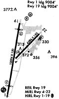
Runways
Runway Summary
| Runways: | 01/19 04/22 |
| Longest Runway: | 01/19 is 10003 ft (3049 m) long |
| Runways with an Instrument Approach: | 01, 19 |
MEI Airport Runway Details
| Runway 01/19 | 10003 ft x 150 ft (3049 m x 46 m) | |
| Runway Length Source: | 3RD PARTY SURVEY as of 03/16/2010 | |
| Surface: | Asphalt/Concrete - Good condition - No special surface treatment | |
| Runway Pavement Class: | 104/F/C/W/T | |
| Runway Edge Lights: | High Intensity | |
Runway Weight Bearing Capacity (in thousands of pounds) |
||
| Single Wheel Landing Gear: | 120.0 | |
| Dual Wheel Landing Gear: | 250.0 | |
| Dual Tandem Wheel Landing Gear: | 550.0 | |
Runway 01 |
Runway 19 |
|
Elevation: |
285.9 | 293.4 |
Latitude: |
32-19-03.7848N | 32-20-41.4640N |
Longitude: |
088-45-23.0461W | 088-45-04.2537W |
|
Runway True Alignment: |
009 | 189 |
ILS Type: |
ILS | ILS/DME |
Glide Path Angle: |
3.0 degrees | 3.0 degrees |
Runway Markings Type: |
Precision Instrument | Precision Instrument |
Runway Markings Condition: |
Good | Good |
Visual Glide Slope Indicators: |
4-Light PAPI On Left Side Of Runway | 4-Light PAPI On Left Side Of Runway |
Runway Visual Range (RVR): |
Touchdown | Touchdown |
Approach Light System: |
1,400 Foot Medium Intensity Approach Lighting System With Runway Alignment Indicator Lights | 1,400 Foot Medium Intensity Approach Lighting System With Runway Alignment Indicator Lights |
REIL: |
No | |
Touchdown Lights: |
No | No |
Centerline Lights: |
No | No |
Threshold Crossing Height: |
54 | 69 |
Threshold Elevation: |
286.7 | 292.9 |
Displaced Threshold: |
990 | 990 |
Threshold Latitude: |
32-19-13.4488N | 32-20-31.8004N |
Threshold Longitude: |
088-45-21.1846W | 088-45-06.1106W |
Declared Distances |
||
Take Off Run Avbl. (TORA): |
10003 | 10003 |
Take Off Distance Avbl. (TODA): |
10003 | 10003 |
Actual Stop Dist. Avbl. (ASDA): |
10003 | 10003 |
Landing Dist. Avbl. (LDA): |
9013 | 9013 |
| Runway 04/22 | 4599 ft x 150 ft (1402 m x 46 m) | |
| Runway Length Source: | 3RD PARTY SURVEY as of 03/16/2010 | |
| Surface: | Asphalt/Concrete - Good condition - No special surface treatment | |
| Runway Pavement Class: | 61 /F/C/W/U | |
| Runway Edge Lights: | Medium Intensity | |
Runway Weight Bearing Capacity (in thousands of pounds) |
||
| Single Wheel Landing Gear: | 120.0 | |
| Dual Wheel Landing Gear: | 213.0 | |
| Dual Tandem Wheel Landing Gear: | 345.0 | |
Runway 04 |
Runway 22 |
|
Elevation: |
289.7 | 297.4 |
Latitude: |
32-19-51.5670N | 32-20-24.3090N |
Longitude: |
088-45-10.2769W | 088-44-33.0512W |
|
Runway True Alignment: |
044 | 224 |
Glide Path Angle: |
3.1 degrees | 3.6 degrees |
Traffic Pattern: |
Left | Left |
Runway Markings Type: |
Nonprecision Instrument | Nonprecision Instrument |
Runway Markings Condition: |
Good | Good |
Object at End: |
TREES | POLE |
Object Height: |
86 | 35 |
Distance from End: |
1926 | 1125 |
Visual Glide Slope Indicators: |
2-Light PAPI On Left Side Of Runway | 2-Light PAPI On Left Side Of Runway |
REIL: |
No | No |
Touchdown Lights: |
No | No |
Centerline Lights: |
No | No |
Threshold Crossing Height: |
19 | 20 |
Declared Distances |
||
Take Off Run Avbl. (TORA): |
4599 | 4599 |
Take Off Distance Avbl. (TODA): |
4599 | 4599 |
Actual Stop Dist. Avbl. (ASDA): |
4599 | 4599 |
Landing Dist. Avbl. (LDA): |
4599 | 4599 |
Services
Airframe Repair: |
None |
Bottled Oxygen: |
None |
Bulk Oxygen: |
None |
Fuel Available: |
100LL |
Landing Fees: |
No |
Parking: |
Tiedowns available |
Maps & Diagrams
MEI Sectional
Flight Planning
at skyvector.com
at skyvector.com