Location
Latitude: |
30-10-55.4000N (30.182056) |
Longitude: |
082-34-36.7000W (-82.576861) |
Elevation: |
200.7 feet MSL (61 m MSL) |
Magnetic Variation: |
6.3 W (as of April 2024 from WMM2020 model) |
Time Zone: |
UTC -5.0 (Standard Time) UTC -4.0 (Daylight Savings Time) |
From City: |
03 N.M. E of Lake City, Florida |
Found On: |
Jacksonville Chart |
FAA Region: |
ASO |
Contacts
Manager: |
Publicly owned: |
| ED BUNNELL 3524 E US HWY 90 LAKE CITY, FL 32055 386-752-1066 |
CITY OF LAKE CITY 205 NORTH MARION AVE LAKE CITY, FL 32055 386-719-5785 |
Operations
Airport Status: |
Operational |
Facility Use: |
Public |
Type: |
Airport |
Activation Date: |
04/1940 |
Control tower: |
Yes |
Attendance (Months/Days/Hours): |
Months/Days/Hours ALL/ALL/0800-1800 |
Boundary ARTCC: |
ZJX (Jacksonville) |
Responsible ARTCC: |
ZJX (Jacksonville) |
Lighting Schedule: |
SEE RMK |
Segmented Circle Indicator: |
Yes |
Traffic Pattern Altitude (MSL): |
1201 feet (366 m) |
NOTAMs Facility: |
GNV |
NOTAM-D Service: |
Yes |
International Airport of Entry: |
No |
Customs Landing Rights: |
No |
Military Landing Rights: |
Yes |
Civil/Military Joint Use: |
No |
Based Aircraft
| Single Engine: | 22 |
| Multi Engine: | 2 |
| Jet Engine: | 2 |
| GA Helicopters: | 3 |
Annual Operations (as of 04/04/2018)
| Total Operations: | 28714 | |
| Air Taxi: | 1300 | 4.5% |
| GA Local: | 11114 | 38.7% |
| GA Itinerant: | 13700 | 47.7% |
| Military Aircraft: | 2600 | 9.1% |
Communications
| CTAF: | 119.200 |
| Unicom: | 122.950 |
| Tower: | LAKE CITY 119.2 314.6 Hrs: 0800-1630 MON-FRI |
| Ground: | 121.9 |
| Approach: | JAX ARTCC |
| Departure: | JAX ARTCC |
| AWOS-3: | 120.675 (386-754-9366) |
| EMERG: | 121.5 |
- APCH/DEP SVC PRVDD BY JACKSONVILLE ARTCC ON FREQS 125.375/254.325 (LAKE CITY RCAG).
- OWNED/OPERATED BY CITY OF LAKE CITY, FL.
- ATCT MAY BE OPEN AT OTHER THAN PUBLISHED HRS; MONITOR CTAF AT ALL TIMES.
Fixed Based Operators (FBOs) & Fuel
(Click on a business for detail)
Please help us keep this information up to date. This is a FREE SERVICE just like everything else on Airport Guide! If you see that a business needs to be added, modified, or deleted please fill out our Update Form.
To add, modify, or delete a business click here.
Please help us keep this information up to date. This is a FREE SERVICE just like everything else on Airport Guide! If you see that a business needs to be added, modified, or deleted please fill out our Update Form.
Area Code: 904 |
| Business Name | Frequency | Phone | Fuel Grade |
|---|---|---|---|
| Lake City Gateway FBO
Website Update FBO info |
119.2 Tower/CTAF | 386-752-1066 | 100LL, Jet A+ |

|
Titan | 100LL - 4.50 USD per gallon on 12/30/2021 |
Trucks |
|
|
Titan | Jet A+ - 4.65 USD per gallon on 12/30/2021 |
Trucks |
Flight Service Stations
| Primary | Alternate | |
| FSS on Field: | N | |
| FSS Name (ID): | Gainesville(GNV) | |
| Frequency: | ||
| Toll Free Phone: | 1-800-WX-BRIEF |
Instrument Procedures / Charts
FAA Terminal Procedures valid from 0901Z 03/21/24 to 0901Z 04/18/24.
There are various types of charts available for an airport. They are listed in the Page Type column. Here is a legend for those types:
APD - Airport Diagram
DP - Departure Procedure Charts
HOT - Hot Spots
IAP - Instrument Approach Procedure Charts
MIN - Minimums
STAR - Standard Terminal Arrival Charts
| Page Type | Page Name | Volume | Action Since Last Cycle |
|---|---|---|---|
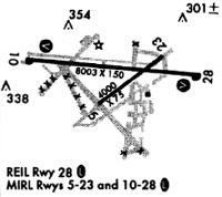
| APD | AIRPORT DIAGRAM | SE-3 | |
| IAP | NDB RWY 28 | SE-3 | |
| IAP | RNAV (GPS) RWY 10 | SE-3 | |
| IAP | RNAV (GPS) RWY 28 | SE-3 | |
| MIN | ALTERNATE MINIMUMS | SE-3 | |
| MIN | TAKEOFF MINIMUMS | SE-3 |
Terminal Procedures are only available for airports in several countries with more being added all the time. If you are looking for a specific country's charts, please send an email to support(at)airportguide.com stating the country name. This will be used to prioritize the implementation.
Navigation Aids (Navaids) near LCQ
| Dist (NM) | ID | Morse Code | Name | Type | Freq | True Hdg | Mag Hdg |
|---|---|---|---|---|---|---|---|
| 0.2 | LCQ | . _ . . _ . _ . _ _ . _ | Lake City | NDB | 204 | 335 | 341 |
| 19.4 | TAY | _ . _ _ . _ _ | Taylor | VORTAC | 112.90 | 3 | 9 |
| 33.4 | GNV | _ _ . _ . . . . _ | Gators | VORTAC | 116.20 | 151 | 157 |
| 35.6 | VQQ | . . . _ _ _ . _ _ _ . _ | Cecil | VOR | 117.90 | 86 | 93 |
| 37.2 | GN | _ _ . _ . | Wynds | NDB | 269 | 145 | 151 |
| 42.7 | CTY | _ . _ . _ _ . _ _ | Cross City | VORTAC | 112.00 | 215 | 221 |
| 43.6 | JA | . _ _ _ . _ | Dinns | NDB | 344 | 66 | 73 |
| 46.9 | NIP | _ . . . . _ _ . | Jacksonville | TACAN | 108.20 | 85 | 92 |
| 49.4 | RYD | . _ . _ . _ _ _ . . | Reynolds | NDB | 338 | 104 | 111 |
| 49.5 | JAX | . _ _ _ . _ _ . . _ | Jacksonville Intl | VOT | 111.00 | 67 | 74 |
| 50.9 | IAK | . . . _ _ . _ | Palatka | NDB | 243 | 128 | 135 |
| 51.1 | OTK | _ _ _ _ _ . _ | Valdosta | VOR-DME | 114.80 | 314 | 320 |
| 52.2 | EYA | . _ . _ _ . _ | Eastport | NDB | 357 | 73 | 80 |
| 53.4 | HOE | . . . . _ _ _ . | Homerville | NDB | 209 | 349 | 355 |
| 56.1 | CRG | _ . _ . . _ . _ _ . | Craig | VORTAC | 114.50 | 80 | 87 |
| 56.5 | VAD | . . . _ . _ _ . . | Moody | TACAN | 113.30 | 325 | 331 |
| 61.0 | NRB | _ . . _ . _ . . . | Mayport | TACAN | 111.40 | 77 | 84 |
| 63.0 | OCF | _ _ _ _ . _ . . . _ . | Ocala | VORTAC | 113.70 | 163 | 169 |
| 65.2 | AYS | . _ _ . _ _ . . . | Waycross | VORTAC | 110.20 | 0 | 6 |
| 66.1 | SGJ | . . . _ _ . . _ _ _ | St Augustine | VOR-DME | 109.40 | 101 | 108 |
Nearby Airports with Fuel
Notices to Airmen (NOTAMS)
Remarks
| A11 | CTC PERSON: DEMETRIUS JOHNSON |
| A110-2 | UNLIT 60 FT POLES ON MOVEMENT AREA. HELICOPTERS ADVISED TO TAXI ON PAVED AREAS ONLY. |
| A110-3 | WHEN ATCT CLSD, FOR CD CTC JACKSONVILLE ARTCC AT 904-845-1592. |
| A17 | TWR ATNDD OTR TIMES BY NOTAM. |
| A39-05/23 | PCR VALUE: 11/F/A/Y/T |
| A81-APT | ACTVT REIL RWY 10 & 28; MIRL RWY 5/23 & 10/28 - CTAF. |
Runways
Runway Summary
| Runways: | 05/23 10/28 |
| Longest Runway: | 10/28 is 8003 ft (2439 m) long |
| Runways with an Instrument Approach: |
LCQ Airport Runway Details
| Runway 05/23 | 4000 ft x 75 ft (1219 m x 23 m) | |
| Runway Length Source: | 3RD PARTY SURVEY as of 06/09/2006 | |
| Surface: | Asphalt - Excellent condition - No special surface treatment | |
| Runway Edge Lights: | Medium Intensity | |
Runway 05 |
Runway 23 |
|
Elevation: |
185.5 | 194.8 |
Latitude: |
30-10-38.4330N | 30-11-02.7892N |
Longitude: |
082-34-49.7795W | 082-34-13.8344W |
|
Runway True Alignment: |
052 | 232 |
Glide Path Angle: |
0.0 degrees | 0.0 degrees |
Traffic Pattern: |
Left | Left |
Runway Markings Type: |
Nonprecision Instrument | Nonprecision Instrument |
Runway Markings Condition: |
Good | Good |
Object at End: |
TREES | TREES |
Object Height: |
64 | 50 |
Distance from End: |
1690 | 1625 |
Object Centerline Offset: |
250 ft. right of centerline | 265 ft. left of centerline |
| Runway 10/28 | 8003 ft x 150 ft (2439 m x 46 m) | |
| Runway Length Source: | 3RD PARTY SURVEY as of 06/09/2006 | |
| Surface: | Asphalt - Excellent condition - No special surface treatment | |
| Runway Pavement Class: | 42 /F/A/W/T | |
| Runway Edge Lights: | Medium Intensity | |
Runway Weight Bearing Capacity (in thousands of pounds) |
||
| Single Wheel Landing Gear: | 75.0 | |
| Dual Wheel Landing Gear: | 105.0 | |
| Dual Tandem Wheel Landing Gear: | 250.0 | |
Runway 10 |
Runway 28 |
|
Elevation: |
198.1 | 196.3 |
Latitude: |
30-11-02.6146N | 30-10-52.8953N |
Longitude: |
082-35-24.4358W | 082-33-53.9557W |
|
Runway True Alignment: |
097 | 277 |
Glide Path Angle: |
3.0 degrees | 3.0 degrees |
Traffic Pattern: |
Left | Right |
Runway Markings Type: |
Nonprecision Instrument | Nonprecision Instrument |
Runway Markings Condition: |
Fair | Fair |
Object at End: |
TREES | TREES |
Object Height: |
57 | 48 |
Distance from End: |
1425 | 1885 |
Object Centerline Offset: |
250 ft. right of centerline | 265 ft. left of centerline |
Visual Glide Slope Indicators: |
2-Light PAPI On Left Side Of Runway | 2-Light PAPI On Left Side Of Runway |
REIL: |
Yes | Yes |
Threshold Crossing Height: |
53 | 51 |
Services
Airframe Repair: |
Minor |
Powerplant Repair: |
Minor |
Bottled Oxygen: |
None |
Bulk Oxygen: |
None |
Fuel Available: |
100LL, Jet A+ |
Landing Fees: |
No |
Parking: |
Tiedowns available |
Maps & Diagrams
LCQ Sectional
Flight Planning
at skyvector.com
at skyvector.com