Location
Latitude: |
42-47-50.6000N (42.797389) |
Longitude: |
109-48-39.7000W (-109.811028) |
Elevation: |
7096.2 feet MSL (2163 m MSL) |
Magnetic Variation: |
10.4 E (as of April 2024 from WMM2020 model) |
Time Zone: |
UTC -7.0 (Standard Time) UTC -6.0 (Daylight Savings Time) |
From City: |
05 N.M. SE of Pinedale, Wyoming |
Found On: |
Salt Lake City Chart |
FAA Region: |
ANM |
Contacts
Manager: |
Publicly owned: |
| RILEY WILSON P O BOX 709 PINEDALE, WY 82941 307-360-9025 |
TOWN OF PINEDALE P. O. BOX 709 PINEDALE, WY 82941 307-367-4136 |
Operations
Airport Status: |
Operational |
Facility Use: |
Public |
Type: |
Airport |
Activation Date: |
05/1940 |
Control tower: |
No |
Attendance (Months/Days/Hours): |
Months/Days/Hours MAY-SEPT/ALL/0800-1800 |
Boundary ARTCC: |
ZLC (Salt Lake City) |
Responsible ARTCC: |
ZLC (Salt Lake City) |
Lighting Schedule: |
SEE RMK |
Segmented Circle Indicator: |
Yes |
Traffic Pattern Altitude (MSL): |
8096 feet (2468 m) |
NOTAMs Facility: |
PNA |
NOTAM-D Service: |
Yes |
International Airport of Entry: |
No |
Customs Landing Rights: |
No |
Military Landing Rights: |
Yes |
Civil/Military Joint Use: |
No |
Based Aircraft
| Single Engine: | 33 |
| GA Helicopters: | 1 |
Annual Operations (as of 06/30/2022)
| Total Operations: | 3946 | |
| Air Taxi: | 1296 | 32.8% |
| GA Local: | 1730 | 43.8% |
| GA Itinerant: | 900 | 22.8% |
| Military Aircraft: | 20 | 0.5% |
Communications
| CTAF: | 122.800 |
| Unicom: | 122.800 |
| AWOS-3: | 118.325 (307-367-6425) |
- APCH/DEP CTL SVC PRVDD BY SALT LAKE ARTCC (ZLC) ON FREQS 128.35/239.25 (BIG PINEY RCAG).
Fixed Based Operators (FBOs) & Fuel
(Click on a business for detail)
Please help us keep this information up to date. This is a FREE SERVICE just like everything else on Airport Guide! If you see that a business needs to be added, modified, or deleted please fill out our Update Form.
To add, modify, or delete a business click here.
Please help us keep this information up to date. This is a FREE SERVICE just like everything else on Airport Guide! If you see that a business needs to be added, modified, or deleted please fill out our Update Form.
Area Code: 307 |
| Business Name | Frequency | Phone | Fuel Grade |
|---|---|---|---|
| New Breed Aviation
Update FBO info |
Unicom 122.8 | 367-2290 | 100LL, Jet A |
Flight Service Stations
| Primary | Alternate | |
| FSS on Field: | N | |
| FSS Name (ID): | Casper(CPR) | |
| Frequency: | ||
| Toll Free Phone: | 1-800-WX-BRIEF |
Instrument Procedures / Charts
FAA Terminal Procedures valid from 0901Z 03/21/24 to 0901Z 04/18/24.
There are various types of charts available for an airport. They are listed in the Page Type column. Here is a legend for those types:
APD - Airport Diagram
DP - Departure Procedure Charts
HOT - Hot Spots
IAP - Instrument Approach Procedure Charts
MIN - Minimums
STAR - Standard Terminal Arrival Charts
| Page Type | Page Name | Volume | Action Since Last Cycle |
|---|---|---|---|
| IAP | RNAV (GPS) RWY 11 | NW-1 | |
| IAP | RNAV (GPS) RWY 29 | NW-1 | |
| MIN | ALTERNATE MINIMUMS | NW-1 | |
| MIN | TAKEOFF MINIMUMS | NW-1 |
Terminal Procedures are only available for airports in several countries with more being added all the time. If you are looking for a specific country's charts, please send an email to support(at)airportguide.com stating the country name. This will be used to prioritize the implementation.
Navigation Aids (Navaids) near KPNA
| Dist (NM) | ID | Morse Code | Name | Type | Freq | True Hdg | Mag Hdg |
|---|---|---|---|---|---|---|---|
| 0.4 | PNA | . _ _ . _ . . _ | Wenz | NDB | 392 | 141 | 131 |
| 18.5 | BPI | _ . . . . _ _ . . . | Big Piney | VOR-DME | 116.50 | 225 | 215 |
| 61.7 | RIW | . _ . . . . _ _ | Riverton | VOR-DME | 114.05 | 74 | 64 |
| 63.7 | JAC | . _ _ _ . _ _ . _ . | Jackson | VOR-DME | 115.40 | 321 | 310 |
| 66.0 | DNW | _ . . _ . . _ _ | Dunoir | VOR-DME | 117.20 | 339 | 328 |
| 77.3 | BOY | _ . . . _ _ _ _ . _ _ | Boysen Reservoir | VOR-DME | 117.80 | 58 | 48 |
| 80.6 | OCS | _ _ _ _ . _ . . . . | Rock Springs | VOR-DME | 116.00 | 153 | 143 |
| 89.4 | FBR | . . _ . _ . . . . _ . | Fort Bridger | VOR-DME | 114.45 | 197 | 187 |
Nearby Airports with Fuel
| Dist (NM) | Name (Airport IDs) | True Hdg | Mag Hdg | Fuel Grade |
|---|---|---|---|---|
| 18.4 | Miley Meml Field Airport (BPI KBPI BPI) |
225 | 215 | 100LL, Jet A |
| 45.4 | Dubois Municipal Airport (KDUB DUB) |
6 | 356 | 100LL, Jet A |
| 47.7 | Hunt Field Airport (LND KLND LND) |
88 | 78 | 100LL, Jet A |
| 50.1 | Afton Municipal Airport (AFO KAFO AFO) |
264 | 253 | 100LL, Jet A |
| 61.5 | Central Wyoming Regional Airport (RIW KRIW RIW) |
74 | 64 | 100LL, Jet A |
| 63.3 | Jackson Hole Airport (JAC KJAC JAC) |
320 | 309 | 100LL, Jet A |
| 67.1 | Kemmerer Municipal Airport (EMM KEMM EMM) |
209 | 199 | 100LL, Jet A |
| 75.2 | Bear Lake County Airport (1U7) |
244 | 233 | 100LL |
| 78.6 | Allen H Tigert Airport (U78) |
264 | 253 | 100LL |
| 79.4 | Southwest Wyoming Regional Airport (RKS KRKS RKS) |
155 | 145 | 100LL, Jet A-1+ |
| 79.8 | Driggs/Reed Meml Airport (KDIJ DIJ) |
315 | 304 | 100LL, Jet A+ |
| 88.3 | Fort Bridger Airport (FBR KFBR FBR) |
197 | 187 | 100LL |
Notices to Airmen (NOTAMS)
Remarks
| A110-4 | ALL HELICOPTER TFC TO COME & GO VIA THE TWY. FLYING OVER BLDGS ADJACENT TO RAMP IS PROHIBITED. |
| A110-5 | ALL TWYS 50 FT WIDE. |
| A110-6 | FOR CD CTC SALT LAKE ARTCC AT 801-320-2568. |
| A17 | SVC AFT HRS CALL 307-413-7888 OR 307-367-2290. |
| A70-FUEL-A | AVBL VIA FULL SVC ONLY. |
| A70-FUEL-10 | 0LL AVBL H24 SELF SVC VIA CREDIT CARD. |
| A81-APT | ACTVT ODALS RWY 11/29, REILS RWY 11 & 29, PAPI RWY 11 & 29 AND MIRL RWY 11/29 - CTAF. |
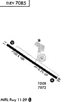
Runways
Runway Summary
| Runways: | 11/29 |
| Longest Runway: | 11/29 is 8900 ft (2713 m) long |
| Runways with an Instrument Approach: |
KPNA Airport Runway Details
| Runway 11/29 | 8900 ft x 100 ft (2713 m x 30 m) | |
| Runway Length Source: | 3RD PARTY SURVEY as of 12/12/2009 | |
| Surface: | Asphalt - Good condition - No special surface treatment | |
| Runway Edge Lights: | Medium Intensity | |
Runway Weight Bearing Capacity (in thousands of pounds) |
||
| Single Wheel Landing Gear: | 45.0 | |
Runway 11 |
Runway 29 |
|
Elevation: |
7096.2 | 7069.4 |
Latitude: |
42-48-14.9308N | 42-47-26.3251N |
Longitude: |
109-49-29.4385W | 109-47-50.0265W |
|
Runway True Alignment: |
123 | 303 |
Glide Path Angle: |
2.8 degrees | 2.8 degrees |
Traffic Pattern: |
Left | Left |
Runway Markings Type: |
Nonprecision Instrument | Nonprecision Instrument |
Runway Markings Condition: |
Fair | Fair |
Visual Glide Slope Indicators: |
4-Light PAPI On Left Side Of Runway | 4-Light PAPI On Left Side Of Runway |
Approach Light System: |
Omnidirectional Approach Lighting System | Omnidirectional Approach Lighting System |
REIL: |
Yes | Yes |
Threshold Crossing Height: |
40 | 40 |
Services
Airframe Repair: |
None |
Powerplant Repair: |
None |
Bottled Oxygen: |
None |
Bulk Oxygen: |
None |
Fuel Available: |
100LL |
Landing Fees: |
No |
Parking: |
Tiedowns available |
Maps & Diagrams
KPNA Sectional
Flight Planning
at skyvector.com
at skyvector.com