Location
Latitude: |
48-24-16.9760N (48.404716) |
Longitude: |
097-22-15.4440W (-97.370957) |
Elevation: |
824.5 feet MSL (251 m MSL) |
Magnetic Variation: |
3 E (as of April 2024 from WMM2020 model) |
Time Zone: |
UTC -6.0 (Standard Time) UTC -5.0 (Daylight Savings Time) |
From City: |
02 N.M. ESE of Grafton, North Dakota |
Found On: |
Twin Cities Chart |
FAA Region: |
AGL |
Contacts
Manager: |
Publicly owned: |
| MATTHEW SCHANILEC 15182 HWY 17 GRAFTON, ND 58237 701-331-1116 |
GRAFTON ARPT AUTH PO BOX 578 GRAFTON, ND 58237 701-352-0271 |
Operations
Airport Status: |
Operational |
Facility Use: |
Public |
Type: |
Airport |
Activation Date: |
10/1947 |
Control tower: |
No |
Attendance (Months/Days/Hours): |
Months/Days/Hours ALL/MON-FRI/DALGT |
Boundary ARTCC: |
ZMP (Minneapolis) |
Responsible ARTCC: |
ZMP (Minneapolis) |
Lighting Schedule: |
SEE RMK |
Segmented Circle Indicator: |
No |
Traffic Pattern Altitude (MSL): |
1824 feet (556 m) |
NOTAMs Facility: |
GFK |
NOTAM-D Service: |
Yes |
International Airport of Entry: |
No |
Customs Landing Rights: |
No |
Military Landing Rights: |
Yes |
Civil/Military Joint Use: |
No |
Based Aircraft
| Single Engine: | 18 |
Annual Operations (as of 09/28/2022)
| Total Operations: | 26450 | |
| Air Taxi: | 300 | 1.1% |
| GA Local: | 5000 | 18.9% |
| GA Itinerant: | 21000 | 79.4% |
| Military Aircraft: | 150 | 0.6% |
Communications
| CTAF: | 122.800 |
| Unicom: | 122.800 |
| Approach: | GRAND FORKS 118.1 118.1 MINNEAPOLIS ARTCC |
| Departure: | GRAND FORKS 118.1 118.1 MINNEAPOLIS ARTCC |
| AWOS-3: | 118.625 (701-352-0581) |
- APCH/DEP SVC PRVDD BY MINNEAPOLIS ARTCC (ZMP) ON FREQ 132.15/269.6 (GRAND FORKS RCAG) WHEN GRAND FORKS (RDR) APCH CTL CLSD.
Fixed Based Operators (FBOs) & Fuel
(Click on a business for detail)
Please help us keep this information up to date. This is a FREE SERVICE just like everything else on Airport Guide! If you see that a business needs to be added, modified, or deleted please fill out our Update Form.
To add, modify, or delete a business click here.
Please help us keep this information up to date. This is a FREE SERVICE just like everything else on Airport Guide! If you see that a business needs to be added, modified, or deleted please fill out our Update Form.
Area Code: 701 |
| Business Name | Frequency | Phone | Fuel Grade |
|---|---|---|---|
| Dakota Aviation
Update FBO info |
Unicom 122.8 | 352-0271 | 100LL, Jet A |
Flight Service Stations
| Primary | Alternate | |
| FSS on Field: | N | |
| FSS Name (ID): | Grand Forks(GFK) | |
| Frequency: | ||
| Toll Free Phone: | 1-800-WX-BRIEF |
Instrument Procedures / Charts
FAA Terminal Procedures valid from 0901Z 03/21/24 to 0901Z 04/18/24.
There are various types of charts available for an airport. They are listed in the Page Type column. Here is a legend for those types:
APD - Airport Diagram
DP - Departure Procedure Charts
HOT - Hot Spots
IAP - Instrument Approach Procedure Charts
MIN - Minimums
STAR - Standard Terminal Arrival Charts
| Page Type | Page Name | Volume | Action Since Last Cycle |
|---|---|---|---|
| IAP | RNAV (GPS) RWY 17 | NC-1 | |
| IAP | RNAV (GPS) RWY 35 | NC-1 | |
| MIN | TAKEOFF MINIMUMS | NC-1 |
Terminal Procedures are only available for airports in several countries with more being added all the time. If you are looking for a specific country's charts, please send an email to support(at)airportguide.com stating the country name. This will be used to prioritize the implementation.
Navigation Aids (Navaids) near KGAF
| Dist (NM) | ID | Morse Code | Name | Type | Freq | True Hdg | Mag Hdg |
|---|---|---|---|---|---|---|---|
| 26.9 | RDR | . _ . _ . . . _ . | Red River | TACAN | 116.40 | 183 | 180 |
| 28.0 | GFK | _ _ . . . _ . _ . _ | Grand Forks | VOR-DME | 114.30 | 164 | 161 |
| 29.6 | HML | . . . . _ _ . _ . . | Humboldt | TACAN | 112.40 | 19 | 16 |
| 34.3 | GF | _ _ . . . _ . | Hiser | NDB | 345 | 167 | 164 |
| 45.4 | CKN | _ . _ . _ . _ _ . | Crookston | NDB | 400 | 137 | 134 |
| 51.4 | TVF | _ . . . _ . . _ . | Thief River Falls | VOR-DME | 114.45 | 112 | 109 |
| 56.3 | HY | . . . . _ . _ _ | Harvi | NDB | 260 | 114 | 112 |
| 64.0 | DVL | _ . . . . . _ . _ . . | Devils Lake | VOR-DME | 114.75 | 254 | 250 |
| 65.4 | PFT | . _ _ . . . _ . _ | Piney Pinecreek | NDB | 342 | 56 | 54 |
| 71.7 | ROX | . _ . _ _ _ _ . . _ | Roseau | VOR-DME | 108.80 | 67 | 65 |
| 74.3 | LF | La Salle | NDB | 336 | 2 | 359 | |
| 80.8 | FSE | . . _ . . . . . | Fosston | NDB | 224 | 126 | 124 |
| 85.6 | ZWW | Boine | NDB | 215 | 2 | 359 | |
| 86.2 | ZHT | Forks | NDB | 236 | 5 | 2 | |
| 86.7 | AA | . _ . _ | Kenie | NDB | 365 | 164 | 161 |
| 88.8 | SW | . . . . _ _ | Roadd | NDB | 360 | 71 | 69 |
| 89.7 | WG | Winnipeg | NDB | 248 | 0 | 357 | |
| 91.5 | YWG | _ . _ _ . _ _ _ _ . | Winnipeg | VORTAC | 115.50 | 3 | 0 |
| 91.9 | PG | Portage | NDB | 353 | 340 | 337 | |
| 93.6 | ZWN | Downs | NDB | 201 | 1 | 358 |
Nearby Airports with Fuel
Notices to Airmen (NOTAMS)
Remarks
| A11 | CHAIRMAN ARPT AUTH RANDY SCHUSTER. |
| A110-1 | BE ALERT: 3 FT DITCH BTN EAST END 8/26 & 17/35, USE DSGND TWYS. |
| A110-10 | FOR CD CTC MINNEAPOLIS ARTCC AT 651-463-5588. |
| A110-2 | LARGE BIRDS AND DEER ON OR INVOF ARPT. |
| A110-3 | HVY AERIAL SPRAY ACTIVITY MAY-OCT. |
| A110-4 | CONFIRM WINTER CONDS AND SNOW REMOVAL WITH AMGR CALL 701-352-0271/ 701-520-9174. |
| A110-5 | NMRS TSNT FLT TRNG ACTIVITIES. |
| A110-6 | RY 17/35 PARALLEL TWY MARKED WITH REFLECTORS. |
| A110-8 | RY 08/26 CLSD WINTER MONTHS DUE TO LACK OF SNOW REMOVAL |
| A110-9 | RWY 08 HAS +3' DITCH 213' FM THRSHOLD |
| A16 | APT MGRS CELL NUMBER 701-520-9174. |
| A17 | FOR SVC AFT HRS CALL 701-352-0271/701-520-9174. |
| A33-08/26 | TURF SOFT WHEN WET. |
| A42-08 | RWY 08/26 - MKD WITH WHITE DALGT END MKRS. |
| A70-FUEL-10 | 0LL 24-HR SELF- SVC FUEL AVBL WITH CREDIT CARD ONLY. |
| A81-APT | MIRL RY 17/35 & PAPI RYS 17 & 35 PRESET ON LOW INTST DUSK-2300; TO INCR INTST AFT 2300 ACTVT - CTAF. |
Runways
Runway Summary
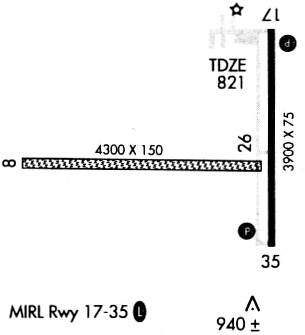
| Runways: | 08/26 17/35 |
| Longest Runway: | 08/26 is 4074 ft (1242 m) long |
| Runways with an Instrument Approach: |
KGAF Airport Runway Details
| Runway 08/26 | 4074 ft x 115 ft (1242 m x 35 m) | |
| Runway Length Source: | 3RD PARTY SURVEY as of 11/02/2016 | |
| Surface: | Turf - Good condition - No special surface treatment | |
Runway 08 |
Runway 26 |
|
Elevation: |
820.6 | 820.8 |
Latitude: |
48-24-14.6252N | 48-24-14.3565N |
Longitude: |
097-23-03.0885W | 097-22-02.7105W |
|
Runway True Alignment: |
090 | 270 |
Glide Path Angle: |
0.0 degrees | 0.0 degrees |
Traffic Pattern: |
Left | Left |
| Runway 17/35 | 3898 ft x 74 ft (1188 m x 23 m) | |
| Runway Length Source: | 3RD PARTY SURVEY as of 11/02/2016 | |
| Surface: | Turf - Good condition - No special surface treatment | |
| Runway Edge Lights: | Medium Intensity | |
Runway Weight Bearing Capacity (in thousands of pounds) |
||
| Single Wheel Landing Gear: | 12.5 | |
Runway 17 |
Runway 35 |
|
Elevation: |
822.2 | 821.9 |
Latitude: |
48-24-38.7961N | 48-24-00.3476N |
Longitude: |
097-21-57.1718W | 097-21-57.2098W |
|
Runway True Alignment: |
180 | 360 |
Glide Path Angle: |
3.0 degrees | 3.0 degrees |
Traffic Pattern: |
Left | Left |
Runway Markings Type: |
Nonprecision Instrument | Nonprecision Instrument |
Runway Markings Condition: |
Fair | Fair |
Visual Glide Slope Indicators: |
2-Light PAPI On Left Side Of Runway | 2-Light PAPI On Left Side Of Runway |
Threshold Crossing Height: |
26 | 26 |
Services
Airframe Repair: |
None |
Powerplant Repair: |
None |
Bottled Oxygen: |
None |
Bulk Oxygen: |
None |
Fuel Available: |
100lL |
Landing Fees: |
No |
Parking: |
Tiedowns available |
Maps & Diagrams
KGAF Sectional
Flight Planning
at skyvector.com
at skyvector.com