Location
Latitude: |
43-21-02.7850N (43.350774) |
Longitude: |
076-23-17.0000W (-76.388056) |
Elevation: |
475.1 feet MSL (145 m MSL) |
Magnetic Variation: |
11.9 W (as of April 2024 from WMM2020 model) |
Time Zone: |
UTC -5.0 (Standard Time) UTC -4.0 (Daylight Savings Time) |
From City: |
03 N.M. NE of Fulton, New York |
Found On: |
New York Chart |
FAA Region: |
AEA |
Contacts
Manager: |
Publicly owned: |
| BRANDON SCHWERDT 40 AIRPORT DRIVE, COUNTY ROUTE 176 FULTON, NY 13069 315-591-9130 |
OSWEGO COUNTY ADMIN 46 E. BRIDGE STRE OSWEGO, NY 13126 315-591- 9130 |
Operations
Airport Status: |
Operational |
Facility Use: |
Public |
Type: |
Airport |
Activation Date: |
06/1947 |
Control tower: |
No |
Attendance (Months/Days/Hours): |
Months/Days/Hours ALL/MON-FRI/0730-1600 |
Boundary ARTCC: |
ZBW (Boston) |
Responsible ARTCC: |
ZBW (Boston) |
Lighting Schedule: |
SEE RMK |
Segmented Circle Indicator: |
No |
Traffic Pattern Altitude (MSL): |
1475 feet (450 m) |
NOTAMs Facility: |
FZY |
NOTAM-D Service: |
Yes |
International Airport of Entry: |
No |
Customs Landing Rights: |
No |
Military Landing Rights: |
Yes |
Civil/Military Joint Use: |
No |
Based Aircraft
| Single Engine: | 83 |
| Jet Engine: | 3 |
| GA Helicopters: | 3 |
Annual Operations (as of 06/14/2018)
| Total Operations: | 20550 | |
| Air Taxi: | 450 | 2.2% |
| GA Local: | 13900 | 67.6% |
| GA Itinerant: | 6000 | 29.2% |
| Military Aircraft: | 200 | 1.0% |
Communications
| CTAF: | 123.000 |
| Unicom: | 123.000 |
| Approach: | SYRACUSE 126.125 126.125 |
| Departure: | SYRACUSE 126.125 126.125 |
| ASOS: | 119.275 (315-598-8773) |
Fixed Based Operators (FBOs) & Fuel
(Click on a business for detail)
Please help us keep this information up to date. This is a FREE SERVICE just like everything else on Airport Guide! If you see that a business needs to be added, modified, or deleted please fill out our Update Form.
To add, modify, or delete a business click here.
Please help us keep this information up to date. This is a FREE SERVICE just like everything else on Airport Guide! If you see that a business needs to be added, modified, or deleted please fill out our Update Form.
Area Code: 315 |
| Business Name | Frequency | Phone | Fuel Grade |
|---|
Flight Service Stations
| Primary | Alternate | |
| FSS on Field: | N | |
| FSS Name (ID): | Buffalo(BUF) | |
| Frequency: | ||
| Toll Free Phone: | 1-800-WX-BRIEF |
Instrument Procedures / Charts
FAA Terminal Procedures valid from 0901Z 03/21/24 to 0901Z 04/18/24.
There are various types of charts available for an airport. They are listed in the Page Type column. Here is a legend for those types:
APD - Airport Diagram
DP - Departure Procedure Charts
HOT - Hot Spots
IAP - Instrument Approach Procedure Charts
MIN - Minimums
STAR - Standard Terminal Arrival Charts
| Page Type | Page Name | Volume | Action Since Last Cycle |
|---|---|---|---|
| APD | AIRPORT DIAGRAM | NE-2 | |
| IAP | ILS OR LOC RWY 33 | NE-2 | |
| IAP | RNAV (GPS) RWY 15 | NE-2 | |
| IAP | RNAV (GPS) RWY 24 | NE-2 | |
| IAP | RNAV (GPS) RWY 33 | NE-2 | |
| MIN | ALTERNATE MINIMUMS | NE-2 | |
| MIN | TAKEOFF MINIMUMS | NE-2 |
Terminal Procedures are only available for airports in several countries with more being added all the time. If you are looking for a specific country's charts, please send an email to support(at)airportguide.com stating the country name. This will be used to prioritize the implementation.
Navigation Aids (Navaids) near KFZY
| Dist (NM) | ID | Morse Code | Name | Type | Freq | True Hdg | Mag Hdg |
|---|---|---|---|---|---|---|---|
| 5.3 | FZ | . . _ . _ _ . . | Falln | NDB | 220 | 136 | 148 |
| 13.9 | SYR | . . . _ . _ _ . _ . | Syracuse | VORTAC | 117.00 | 144 | 156 |
| 38.7 | ART | . _ . _ . _ | Watertown | VORTAC | 109.80 | 21 | 33 |
| 41.7 | GGT | _ _ . _ _ . _ | Georgetown | TACAN | 117.80 | 143 | 155 |
| 51.4 | ITH | . . _ . . . . | Ithaca | DME | 111.8 | 183 | 195 |
| 51.6 | PYA | . _ _ . _ . _ _ . _ | Penn Yan | NDB | 260 | 214 | 226 |
| 51.6 | GTB | _ _ . _ _ . . . | Drum | NDB | 257 | 32 | 44 |
| 55.2 | IT | . . _ | Vrnah | NDB | 266 | 179 | 191 |
| 57.0 | UCA | . . _ _ . _ . . _ | Utica | TACAN | 111.20 | 109 | 121 |
| 57.5 | YGK | Kingston | NDB | 263 | 350 | 362 | |
| 57.9 | ROC | . _ . _ _ _ _ . _ . | Rochester | VOR-DME | 110.00 | 256 | 268 |
| 63.8 | AVN | . _ . . . _ _ . | Avon | NDB | 344 | 251 | 263 |
| 64.5 | 6M | Belleville | NDB | 283 | 322 | 334 | |
| 66.6 | GEE | _ _ . . . | Geneseo | VOR-DME | 108.20 | 242 | 254 |
| 67.0 | YTR | Trenton | NDB | 215 | 319 | 331 | |
| 67.7 | UTR | Trenton | TACAN | 109.70 | 313 | 325 | |
| 68.3 | ZZR | Severn | NDB | 317 | 308 | 320 | |
| 68.7 | ALP | . _ . _ . . . _ _ . | Alpine | NDB | 245 | 194 | 206 |
| 72.4 | CFB | _ . _ . . . _ . _ . . . | Binghamton | VOR-DME | 112.20 | 171 | 183 |
| 73.2 | RKA | . _ . _ . _ . _ | Rockdale | VOR-DME | 112.60 | 136 | 148 |
Nearby Airports with Fuel
Notices to Airmen (NOTAMS)
Remarks
| A110-10 | DURING PERIODS OF SNOW REMOVAL OPNS NOV 1 THRU APR 1 ACFT MUST CTC ARPT ON FREQ 123.0 10 MINS PRIOR TO LDG. |
| A110-11 | RWY 33 DESIGNATED CALM WIND RWY. |
| A110-12 | FOR CD CTC SYRACUSE APCH AT 315-455-6218. |
| A110-13 | AVOID VCNTY OF TWR DUE NORTH ON LAKESHORE. |
| A110-4 | AIRCRAFT DE-ICING AVAILABLE, CONTACT AIRPORT MANAGER AT 315-591-9130. |
| A110-5 | ATTENDANCE OTHER HOURS - CALL ARPT MGR. |
| A110-6 | DEER AND BIRDS ON OR INVOF ARPT. |
| A110-7 | GRASS CUTTING EQUIPMENT OPS ADJACENT TO ALL OPERATIONA SURFACES DALGHT HRS MAY THRU OCT. |
| A110-8 | RWY CONDITIONS MAY NOT BE MONITORED OR REPORTED WHEN ARPT IS UNATNDD. |
| A110-9 | ULTRLGT ACTIVITY ON AND INVOF ARPT. |
| A39-06/24 | PCR VALUE: 31/F/B/W/T |
| A39-15/33 | PCR VALUE: 31/F/B/W/T |
| A55-06 | 50FT+ HILL 1100FT FM RWY END |
| A58-15 | RY 15 +14 FT HILL 0-200 FT FM THLD. HILL BEGINS 295 FT LEFT. |
| A58-33 | RY 33 +7 FT GND 0-199 FT FM THLD 335 FT RIGHT. |
| A81-APT | HIRL RWY 15/33 & PAPI RWY 33 OPR SS-SR AND PRESET LOW INTST; TO INCR INTST AND ACTVT REIL RWY 15/33; HIRL RWY 15/33; MIRL RWY 06/24; PAPI RWY 33 - CTAF. |
| A83 | LIGHTED MAIN WIND INDICATOR PLUS LIGHTED INDICATORS AT EACH RUNWAY END |
| E111 | EXISTED PRIOR TO 1959. |
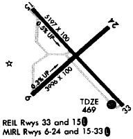
Runways
Runway Summary
| Runways: | 06/24 15/33 |
| Longest Runway: | 15/33 is 5196 ft (1584 m) long |
| Runways with an Instrument Approach: | 33 |
KFZY Airport Runway Details
| Runway 06/24 | 3997 ft x 100 ft (1218 m x 30 m) | |
| Runway Length Source: | 3RD PARTY SURVEY as of 02/14/2023 | |
| Surface: | Asphalt - Good condition - Saw-cut or plastic grooved | |
| Runway Edge Lights: | Medium Intensity | |
Runway Weight Bearing Capacity (in thousands of pounds) |
||
| Single Wheel Landing Gear: | 80.0 | |
| Dual Wheel Landing Gear: | 123.0 | |
Runway 06 |
Runway 24 |
|
Elevation: |
457.1 | 469.1 |
Latitude: |
43-20-47.3337N | 43-21-14.3052N |
Longitude: |
076-23-36.8277W | 076-22-57.3371W |
|
Runway True Alignment: |
047 | 227 |
Glide Path Angle: |
0.0 degrees | 0.0 degrees |
Traffic Pattern: |
Left | Left |
Runway Markings Type: |
Nonprecision Instrument | Nonprecision Instrument |
Runway Markings Condition: |
Good | Good |
Object at End: |
TREES | POLE |
Object Height: |
41 | 49 |
Distance from End: |
364 | 711 |
Object Centerline Offset: |
263 ft. right of centerline | 345 ft. right of centerline |
REIL: |
Yes | Yes |
Touchdown Lights: |
No | No |
Centerline Lights: |
No | No |
| Runway 15/33 | 5196 ft x 100 ft (1584 m x 30 m) | |
| Runway Length Source: | 3RD PARTY SURVEY as of 02/14/2023 | |
| Surface: | Asphalt - Good condition - Saw-cut or plastic grooved | |
| Runway Edge Lights: | High Intensity | |
Runway Weight Bearing Capacity (in thousands of pounds) |
||
| Single Wheel Landing Gear: | 80.0 | |
| Dual Wheel Landing Gear: | 123.0 | |
Runway 15 |
Runway 33 |
|
Elevation: |
446.3 | 475.0 |
Latitude: |
43-21-23.0310N | 43-20-45.5607N |
Longitude: |
076-23-40.9638W | 076-22-52.9132W |
|
Runway True Alignment: |
137 | 317 |
ILS Type: |
ILS/DME | |
Glide Path Angle: |
0.0 degrees | 3.5 degrees |
Traffic Pattern: |
Left | Left |
Runway Markings Type: |
Precision Instrument | Precision Instrument |
Runway Markings Condition: |
Good | Good |
Object at End: |
POLE | ROAD |
Object Height: |
56 | 96 |
Distance from End: |
417 | 1563 |
Object Centerline Offset: |
263 ft. right of centerline | 345 ft. right of centerline |
Visual Glide Slope Indicators: |
4-Light PAPI On Left Side Of Runway | |
REIL: |
Yes | Yes |
Touchdown Lights: |
No | No |
Centerline Lights: |
No | No |
Threshold Crossing Height: |
36 | |
Threshold Elevation: |
471.3 | |
Displaced Threshold: |
414 | |
Threshold Latitude: |
43-20-48.5432N | |
Threshold Longitude: |
076-22-56.7372W | |
Declared Distances |
||
Take Off Run Avbl. (TORA): |
5196 | |
Take Off Distance Avbl. (TODA): |
5196 | |
Actual Stop Dist. Avbl. (ASDA): |
5196 | |
Landing Dist. Avbl. (LDA): |
5196 | |
Services
Airframe Repair: |
Major |
Powerplant Repair: |
Major |
Bottled Oxygen: |
High Pressure / Low Pressure |
Bulk Oxygen: |
None |
Fuel Available: |
100LL, Jet A |
Landing Fees: |
No |
Parking: |
Hangars and tiedowns available |
Maps & Diagrams
KFZY Sectional
Flight Planning
at skyvector.com
at skyvector.com