Location
Latitude: |
41-04-17.0000N (41.071389) |
Longitude: |
087-50-46.6000W (-87.846278) |
Elevation: |
629.5 feet MSL (192 m MSL) |
Magnetic Variation: |
3.9 W (as of April 2024 from WMM2020 model) |
Time Zone: |
UTC -6.0 (Standard Time) UTC -5.0 (Daylight Savings Time) |
From City: |
03 N.M. S of Kankakee, Illinois |
Found On: |
Chicago Chart |
FAA Region: |
AGL |
Contacts
Manager: |
Publicly owned: |
| JEFF BENOIT 813A E. 4000 S. ROAD KANKAKEE, IL 60901 815-939-1422 |
KANKAKEE VALLEY ARPT AUTH 813A E. 4000 S. RD KANKAKEE, IL 60901 815-939-1422 |
Operations
Airport Status: |
Operational |
Facility Use: |
Public |
Type: |
Airport |
Control tower: |
No |
Attendance (Months/Days/Hours): |
Months/Days/Hours APR-OCT/ALL/0700-1730 |
Boundary ARTCC: |
ZAU (Chicago) |
Responsible ARTCC: |
ZAU (Chicago) |
Lighting Schedule: |
SEE RMK |
Segmented Circle Indicator: |
Yes |
Traffic Pattern Altitude (MSL): |
1630 feet (497 m) |
NOTAMs Facility: |
IKK |
NOTAM-D Service: |
Yes |
International Airport of Entry: |
No |
Customs Landing Rights: |
No |
Military Landing Rights: |
Yes |
Civil/Military Joint Use: |
No |
Based Aircraft
| Single Engine: | 62 |
| Multi Engine: | 8 |
| Jet Engine: | 1 |
Annual Operations (as of 08/31/2023)
| Total Operations: | 50000 | |
| Air Taxi: | 1000 | 2.0% |
| GA Local: | 25000 | 50.0% |
| GA Itinerant: | 21000 | 42.0% |
| Military Aircraft: | 3000 | 6.0% |
Communications
| CTAF: | 123.000 |
| Unicom: | 123.000 |
| AWOS-3: | 128.475 (815-939-4044) |
- APCH/DEP SVC PRVDD BY CHICAGO ARTCC (ZAU) ON FREQS 132.5/284.7 (KANKAKEE RCAG).
Fixed Based Operators (FBOs) & Fuel
(Click on a business for detail)
Please help us keep this information up to date. This is a FREE SERVICE just like everything else on Airport Guide! If you see that a business needs to be added, modified, or deleted please fill out our Update Form.
To add, modify, or delete a business click here.
Please help us keep this information up to date. This is a FREE SERVICE just like everything else on Airport Guide! If you see that a business needs to be added, modified, or deleted please fill out our Update Form.
Area Code: 815 |
| Business Name | Frequency | Phone | Fuel Grade |
|---|---|---|---|
| Cooley Bros. Aviation, Inc.
Update FBO info |
939-4449 | ||
| K3 Aeronautics II
Update FBO info |
939-3575 | ||
| Kankakee Valley Airport Authority
Update FBO info |
Unicom 123.0 | 939-3400, 939-1422 | 100LL, Jet A |
Flight Service Stations
| Primary | Alternate | |
| FSS on Field: | N | |
| FSS Name (ID): | Kankakee(IKK) | |
| Frequency: | ||
| Toll Free Phone: | 1-800-WX-BRIEF |
Instrument Procedures / Charts
FAA Terminal Procedures valid from 0901Z 03/21/24 to 0901Z 04/18/24.
There are various types of charts available for an airport. They are listed in the Page Type column. Here is a legend for those types:
APD - Airport Diagram
DP - Departure Procedure Charts
HOT - Hot Spots
IAP - Instrument Approach Procedure Charts
MIN - Minimums
STAR - Standard Terminal Arrival Charts
| Page Type | Page Name | Volume | Action Since Last Cycle |
|---|---|---|---|
| IAP | ILS OR LOC RWY 04 | EC-3 | |
| IAP | RNAV (GPS) RWY 04 | EC-3 | |
| IAP | RNAV (GPS) RWY 16 | EC-3 | |
| IAP | RNAV (GPS) RWY 22 | EC-3 | |
| IAP | RNAV (GPS) RWY 34 | EC-3 | |
| MIN | ALTERNATE MINIMUMS | EC-3 | |
| MIN | TAKEOFF MINIMUMS | EC-3 |
Terminal Procedures are only available for airports in several countries with more being added all the time. If you are looking for a specific country's charts, please send an email to support(at)airportguide.com stating the country name. This will be used to prioritize the implementation.
Navigation Aids (Navaids) near IKK
| Dist (NM) | ID | Morse Code | Name | Type | Freq | True Hdg | Mag Hdg |
|---|---|---|---|---|---|---|---|
| 0.3 | IKK | . . _ . _ _ . _ | Kankakee | DME | 111.6 | 315 | 319 |
| 4.1 | IK | . . _ . _ | Lukow | NDB | 272 | 219 | 223 |
| 12.2 | EON | . _ _ _ _ . | Peotone | VORTAC | 113.20 | 11 | 15 |
| 29.1 | CGT | _ . _ . _ _ . _ | Chicago Heights | VORTAC | 114.20 | 25 | 29 |
| 32.7 | RBS | . _ . _ . . . . . . | Roberts | VOR-DME | 116.80 | 206 | 210 |
| 35.6 | JOT | . _ _ _ _ _ _ _ | Joliet | VOR-DME | 112.30 | 323 | 327 |
| 38.9 | HK | . . . . _ . _ | Ermin | NDB | 332 | 0 | 4 |
| 40.8 | MX | _ _ _ . . _ | Kedzi | NDB | 248 | 9 | 13 |
| 42.9 | PNT | . _ _ . _ . _ | Pontiac | VOR-DME | 109.60 | 249 | 253 |
| 43.1 | MDW | _ _ _ . . . _ _ | Chicago Midway | VOT | 111.00 | 5 | 9 |
| 46.9 | BVT | _ . . . . . . _ _ | Boiler | VORTAC | 115.10 | 130 | 134 |
| 48.5 | DNV | _ . . _ . . . . _ | Danville | VORTAC | 111.00 | 164 | 168 |
| 48.7 | OIX | _ _ _ . . _ . . _ | Ottawa | NDB | 266 | 291 | 295 |
| 49.1 | DN | _ . . _ . | Julip | NDB | 332 | 162 | 166 |
| 49.3 | VP | . . . _ . _ _ . | Sedly | NDB | 212 | 62 | 66 |
| 52.9 | LA | . _ . . . _ | Earle | NDB | 401 | 136 | 140 |
| 54.1 | DPA | _ . . . _ _ . . _ | Dupage | VOR-DME | 108.40 | 335 | 339 |
| 54.4 | ME | _ _ . | Deana | NDB | 350 | 351 | 355 |
| 54.8 | IUL | . . . . _ . _ . . | La Porte | NDB | 356 | 61 | 65 |
| 55.0 | ORD | _ _ _ . _ . _ . . | Chicago O'hare | VOR-DME | 113.90 | 357 | 361 |
Nearby Airports with Fuel
Notices to Airmen (NOTAMS)
Remarks
| A110-3 | DEER & WATERFOWL ON & INVOF ARPT. |
| A110-7 | PPR REQ FOR ULTRALIGHT OPS CTC AMGR. ULTRALIGHT ACT IN GRASS AREA W OF RWY 04/22 & E OF RWY 16/34. |
| A110-8 | FOR CD IF UNA TO CTC ON FSS FREQ, CTC CHICAGO ARTCC AT 630-906-8921. |
| A14 | EMAIL ADDRESS: ADMIN@KVAA.COM |
| A81-APT | ACTVT MALSR RWY 04; REIL RWY 22; HIRL RWY 04/22; MIRL RWY 16/34 - CTAF. HIRL RWY 04/22 PRESET TO LOW INTST; TO INCR INTST - CTAF. |
Runways
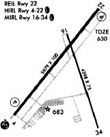
Runway Summary
| Runways: | 04/22 16/34 |
| Longest Runway: | 04/22 is 5981 ft (1823 m) long |
| Runways with an Instrument Approach: | 04 |
IKK Airport Runway Details
| Runway 04/22 | 5981 ft x 100 ft (1823 m x 30 m) | |
| Runway Length Source: | 3RD PARTY SURVEY as of 12/03/2011 | |
| Surface: | Asphalt - Good condition - Porous friction course | |
| Runway Edge Lights: | High Intensity | |
Runway Weight Bearing Capacity (in thousands of pounds) |
||
| Single Wheel Landing Gear: | 60.0 | |
| Dual Wheel Landing Gear: | 95.0 | |
Runway 04 |
Runway 22 |
|
Elevation: |
624.2 | 629.5 |
Latitude: |
41-03-56.8409N | 41-04-43.2018N |
Longitude: |
087-51-17.5687W | 087-50-29.1432W |
|
Runway True Alignment: |
038 | 218 |
ILS Type: |
ILS | |
Glide Path Angle: |
3.0 degrees | 3.0 degrees |
Traffic Pattern: |
Left | Left |
Runway Markings Type: |
Precision Instrument | Nonprecision Instrument |
Runway Markings Condition: |
Fair | Fair |
Visual Glide Slope Indicators: |
4-Light PAPI On Left Side Of Runway | 4-Light PAPI On Left Side Of Runway |
Approach Light System: |
1,400 Foot Medium Intensity Approach Lighting System With Runway Alignment Indicator Lights | |
REIL: |
No | Yes |
Threshold Crossing Height: |
51 | 37 |
| Runway 16/34 | 4398 ft x 75 ft (1341 m x 23 m) | |
| Runway Length Source: | 3RD PARTY SURVEY as of 12/03/2011 | |
| Surface: | Asphalt - Good condition - Saw-cut or plastic grooved | |
| Runway Edge Lights: | Medium Intensity | |
Runway Weight Bearing Capacity (in thousands of pounds) |
||
| Single Wheel Landing Gear: | 30.0 | |
| Dual Wheel Landing Gear: | 40.0 | |
Runway 16 |
Runway 34 |
|
Elevation: |
620.8 | 616.8 |
Latitude: |
41-04-33.5410N | 41-03-52.4333N |
Longitude: |
087-50-46.6327W | 087-50-28.0039W |
|
Runway True Alignment: |
161 | 341 |
Glide Path Angle: |
3.0 degrees | 3.0 degrees |
Traffic Pattern: |
Left | Left |
Runway Markings Type: |
Nonprecision Instrument | Nonprecision Instrument |
Runway Markings Condition: |
Good | Good |
Object at End: |
TREE | |
Object Height: |
58 | |
Distance from End: |
712 | |
Visual Glide Slope Indicators: |
4-Light PAPI On Left Side Of Runway | 4-Light PAPI On Left Side Of Runway |
Threshold Crossing Height: |
40 | 37 |
Services
Fuel Available: |
100LL, Jet A |
Landing Fees: |
Yes |
Parking: |
Hangars and tiedowns available |
Other Services: |
Meeting Rooms, Gournet Deli Shop, Picnic facilities, Horseback Riding, Swimming |
Maps & Diagrams
IKK Sectional
Flight Planning
at skyvector.com
at skyvector.com