Location
Latitude: |
34-02-01.1000N (34.033639) |
Longitude: |
095-32-31.4000W (-95.542056) |
Elevation: |
572.2 feet MSL (174 m MSL) |
Magnetic Variation: |
1.9 E (as of April 2024 from WMM2020 model) |
Time Zone: |
UTC -6.0 (Standard Time) UTC -5.0 (Daylight Savings Time) |
From City: |
02 N.M. NW of Hugo, Oklahoma |
Found On: |
Dallas-Ft Worth Chart |
FAA Region: |
ASW |
Contacts
Manager: |
Publicly owned: |
| STEVE HOLMAN 858 N. 4210 RD. HUGO, OK 74743 580-317-3513 |
CITY OF HUGO 201 S SECOND ST HUGO, OK 74743 580-326-2344 |
Operations
Airport Status: |
Operational |
Facility Use: |
Public |
Type: |
Airport |
Activation Date: |
08/1985 |
Control tower: |
No |
Attendance (Months/Days/Hours): |
Months/Days/Hours ALL/MON-FRI/0700-1600 |
Boundary ARTCC: |
ZFW (Fort Worth) |
Responsible ARTCC: |
ZFW (Fort Worth) |
Lighting Schedule: |
SEE RMK |
Segmented Circle Indicator: |
Yes |
Traffic Pattern Altitude (MSL): |
1572 feet (479 m) |
NOTAMs Facility: |
MLC |
NOTAM-D Service: |
Yes |
Military Landing Rights: |
No |
Based Aircraft
| Single Engine: | 17 |
| Multi Engine: | 2 |
Annual Operations (as of 08/07/2018)
| Total Operations: | 4835 | |
| Air Taxi: | 300 | 6.2% |
| GA Local: | 2260 | 46.7% |
| GA Itinerant: | 2175 | 45.0% |
| Military Aircraft: | 100 | 2.1% |
Communications
| CTAF: | 122.800 |
| Unicom: | 122.800 |
| AWOS-3: | 119.025 (580-326-2134) |
- APCH/DEP CTL SVC PRVDD BY FORT WORTH ARTCC (ZFW) ON FREQS 127.6 (BLUE RIDGE/B RCAG)/ 307.2 (BLUE RIDGE/A RCAG).
Fixed Based Operators (FBOs) & Fuel
(Click on a business for detail)
Please help us keep this information up to date. This is a FREE SERVICE just like everything else on Airport Guide! If you see that a business needs to be added, modified, or deleted please fill out our Update Form.
To add, modify, or delete a business click here.
Please help us keep this information up to date. This is a FREE SERVICE just like everything else on Airport Guide! If you see that a business needs to be added, modified, or deleted please fill out our Update Form.
Area Code: 580 |
| Business Name | Frequency | Phone | Fuel Grade |
|---|
Flight Service Stations
| Primary | Alternate | |
| FSS on Field: | ||
| FSS Name (ID): | Mc Alester(MLC) | |
| Frequency: | ||
| Toll Free Phone: | 1-800-WX-BRIEF |
Instrument Procedures / Charts
FAA Terminal Procedures valid from 0901Z 03/21/24 to 0901Z 04/18/24.
There are various types of charts available for an airport. They are listed in the Page Type column. Here is a legend for those types:
APD - Airport Diagram
DP - Departure Procedure Charts
HOT - Hot Spots
IAP - Instrument Approach Procedure Charts
MIN - Minimums
STAR - Standard Terminal Arrival Charts
| Page Type | Page Name | Volume | Action Since Last Cycle |
|---|---|---|---|
| IAP | RNAV (GPS) RWY 17 | SC-1 | |
| IAP | RNAV (GPS) RWY 35 | SC-1 | |
| MIN | ALTERNATE MINIMUMS | SC-1 | |
| MIN | TAKEOFF MINIMUMS | SC-1 |
Terminal Procedures are only available for airports in several countries with more being added all the time. If you are looking for a specific country's charts, please send an email to support(at)airportguide.com stating the country name. This will be used to prioritize the implementation.
Navigation Aids (Navaids) near HUJ
| Dist (NM) | ID | Morse Code | Name | Type | Freq | True Hdg | Mag Hdg |
|---|---|---|---|---|---|---|---|
| 0.4 | HHW | . . . . . . . . . _ _ | Hugo | NDB | 323 | 19 | 17 |
| 29.8 | PRX | . _ _ . . _ . _ . . _ | Paris | VOR-DME | 113.60 | 170 | 168 |
| 42.6 | URH | . . _ . _ . . . . . | Texoma | DME | 114.3 | 263 | 261 |
| 45.6 | BYP | _ . . . _ . _ _ . _ _ . | Bonham | VORTAC | 114.60 | 229 | 227 |
| 47.9 | ML | _ _ . _ . . | Wampa | NDB | 344 | 343 | 341 |
| 50.1 | SLR | . . . . _ . . . _ . | Sulphur Springs | DME | 109 | 180 | 178 |
| 50.4 | MLC | _ _ . _ . . _ . _ . | Mc Alester | TACAN | 112.00 | 346 | 344 |
| 57.5 | DNI | _ . . _ . . . | Denison | NDB | 341 | 257 | 255 |
| 60.4 | PGO | . _ _ . _ _ . _ _ _ | Rich Mountain | VORTAC | 113.50 | 49 | 47 |
| 63.6 | MJF | _ _ . _ _ _ . . _ . | Arvilla | TACAN | 109.60 | 204 | 202 |
| 68.4 | SYW | . . . _ . _ _ . _ _ | Cash | NDB | 428 | 202 | 200 |
| 69.3 | MII | _ _ . . . . | Caddo Mills | NDB | 316 | 210 | 208 |
| 69.7 | UIM | . . _ . . _ _ | Quitman | DME | 114 | 172 | 170 |
| 69.8 | VLY | . . . _ . _ . . _ . _ _ | Melisa | NDB | 421 | 228 | 226 |
| 70.1 | AI | . _ . . | Addmo | NDB | 400 | 280 | 278 |
| 72.4 | ADH | . _ _ . . . . . . | Ada | VOR-DME | 117.80 | 309 | 307 |
| 78.9 | VM | . . . _ _ _ | Fench | NDB | 352 | 66 | 65 |
| 79.6 | TXK | _ _ . . _ _ . _ | Texarkana | VORTAC | 116.30 | 112 | 111 |
| 81.5 | ADM | . _ _ . . _ _ | Ardmore | VORTAC | 116.70 | 277 | 275 |
| 84.2 | AVZ | . _ . . . _ _ _ . . | Travis | NDB | 260 | 205 | 203 |
Nearby Airports with Fuel
Notices to Airmen (NOTAMS)
Remarks
| A110-1 | FOR CD CTC FORT WORTH ARTCC AT 817-858-7584. |
| A17 | FOR ARPT ATTENDANT AFTER HOURS CALL 580-326-2302. |
| A70-FUEL-10 | 0LL FUEL AVBL 24 HR SELF SERVICE WITH MAJOR CREDIT CARD. |
| A81-APT | ACTVT MIRL RWY 17/35, REILS RWY 17/35- CTAF. |
| E111 | PRVDD ANTENNA 9000 FT SE OF ARPT REMOVED. |
Runways
Runway Summary
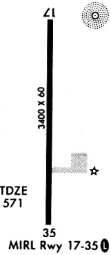
| Runways: | 17/35 |
| Longest Runway: | 17/35 is 4007 ft (1221 m) long |
| Runways with an Instrument Approach: |
HUJ Airport Runway Details
| Runway 17/35 | 4007 ft x 75 ft (1221 m x 23 m) | |
| Runway Length Source: | 3RD PARTY SURVEY as of 08/07/2011 | |
| Surface: | Asphalt - Good condition - No special surface treatment | |
| Runway Edge Lights: | Medium Intensity | |
Runway Weight Bearing Capacity (in thousands of pounds) |
||
| Single Wheel Landing Gear: | 12.5 | |
Runway 17 |
Runway 35 |
|
Elevation: |
567.1 | 572.2 |
Latitude: |
34-02-20.9323N | 34-01-41.2913N |
Longitude: |
095-32-31.4760W | 095-32-31.3654W |
|
Runway True Alignment: |
180 | 000 |
Glide Path Angle: |
3.0 degrees | 3.0 degrees |
Runway Markings Type: |
Nonprecision Instrument | Nonprecision Instrument |
Runway Markings Condition: |
Good | Good |
Object at End: |
TREES | TREES |
Object Height: |
30 | 36 |
Distance from End: |
318 | 1239 |
Object Centerline Offset: |
240 ft. right of centerline | 0 ft. left and right of centerline |
Visual Glide Slope Indicators: |
2-Light PAPI On Left Side Of Runway | 2-Light PAPI On Left Side Of Runway |
REIL: |
Yes | Yes |
Threshold Crossing Height: |
44 | 43 |
Services
Airframe Repair: |
Major |
Powerplant Repair: |
Major |
Bottled Oxygen: |
None |
Bulk Oxygen: |
None |
Fuel Available: |
100LL, Jet A+ |
Landing Fees: |
No |
Parking: |
Tiedowns available |
Maps & Diagrams
HUJ Sectional
Flight Planning
at skyvector.com
at skyvector.com