Location
Latitude: |
42-55-01.4910N (42.917081) |
Longitude: |
114-45-58.8170W (-114.766338) |
Elevation: |
3732.3 feet MSL (1138 m MSL) |
Magnetic Variation: |
12.3 E (as of April 2024 from WMM2020 model) |
Time Zone: |
UTC -7.0 (Standard Time) UTC -6.0 (Daylight Savings Time) |
From City: |
03 N.M. SW of Gooding, Idaho |
Found On: |
Salt Lake City Chart |
FAA Region: |
ANM |
Contacts
Manager: |
Publicly owned: |
| DALE THOMAS 1920 AIRPORT ROAD GOODING, ID 83330 (208) 539-5934 |
CITY OF GOODING 308 5TH AVE WEST, - CITY SUPERINTENDENT GOODING, ID 83330 (208) 961-0376 |
Operations
Airport Status: |
Operational |
Facility Use: |
Public |
Type: |
Airport |
Activation Date: |
03/1942 |
Control tower: |
No |
Attendance (Months/Days/Hours): |
Months/Days/Hours ALL/ALL/0800-1700 |
Boundary ARTCC: |
ZLC (Salt Lake City) |
Responsible ARTCC: |
ZLC (Salt Lake City) |
Lighting Schedule: |
SEE RMK |
Segmented Circle Indicator: |
Yes |
Traffic Pattern Altitude (MSL): |
4732 feet (1442 m) |
NOTAMs Facility: |
BOI |
NOTAM-D Service: |
Yes |
International Airport of Entry: |
No |
Customs Landing Rights: |
No |
Military Landing Rights: |
Yes |
Civil/Military Joint Use: |
No |
Based Aircraft
| Single Engine: | 84 |
| Multi Engine: | 2 |
| GA Helicopters: | 5 |
Annual Operations (as of 04/30/2021)
| Total Operations: | 26800 | |
| Air Taxi: | 100 | 0.4% |
| GA Local: | 12650 | 47.2% |
| GA Itinerant: | 14000 | 52.2% |
| Military Aircraft: | 50 | 0.2% |
Communications
| CTAF: | 122.800 |
| Unicom: | 122.800 |
| AWOS-3PT: | 124.175 (208 934 4950) |
- APCH/DEP CTL SVC PRVDD BY SALT LAKE ARTCC (ZLC) ON FREQS 118.05/363.0 (BLISS RCAG).
- COMMUNICATIONS PRVDD BY BOISE RADIO ON FREQ 122.4 (BLISS RCO).
Fixed Based Operators (FBOs) & Fuel
(Click on a business for detail)
Please help us keep this information up to date. This is a FREE SERVICE just like everything else on Airport Guide! If you see that a business needs to be added, modified, or deleted please fill out our Update Form.
To add, modify, or delete a business click here.
Please help us keep this information up to date. This is a FREE SERVICE just like everything else on Airport Guide! If you see that a business needs to be added, modified, or deleted please fill out our Update Form.
Area Code: 208 |
| Business Name | Frequency | Phone | Fuel Grade |
|---|---|---|---|
| High Range Aviation, Inc.
Update FBO info |
Unicom 122.8 | 934-5934 | 100LL, Jet A |
Flight Service Stations
| Primary | Alternate | |
| FSS on Field: | N | |
| FSS Name (ID): | Boise(BOI) | |
| Frequency: | ||
| Toll Free Phone: | 1-800-WX-BRIEF |
Instrument Procedures / Charts
FAA Terminal Procedures valid from 0901Z 03/21/24 to 0901Z 04/18/24.
There are various types of charts available for an airport. They are listed in the Page Type column. Here is a legend for those types:
APD - Airport Diagram
DP - Departure Procedure Charts
HOT - Hot Spots
IAP - Instrument Approach Procedure Charts
MIN - Minimums
STAR - Standard Terminal Arrival Charts
| Page Type | Page Name | Volume | Action Since Last Cycle |
|---|---|---|---|
| IAP | RNAV (GPS) RWY 07 | NW-1 | |
| IAP | RNAV (GPS) RWY 25 | NW-1 | |
| MIN | ALTERNATE MINIMUMS | NW-1 | |
| MIN | TAKEOFF MINIMUMS | NW-1 |
Terminal Procedures are only available for airports in several countries with more being added all the time. If you are looking for a specific country's charts, please send an email to support(at)airportguide.com stating the country name. This will be used to prioritize the implementation.
Navigation Aids (Navaids) near GNG
| Dist (NM) | ID | Morse Code | Name | Type | Freq | True Hdg | Mag Hdg |
|---|---|---|---|---|---|---|---|
| 4.0 | HDG | . . . . _ . . _ _ . | Steelhead | NDB | 211 | 90 | 78 |
| 28.9 | TWF | _ . _ _ . . _ . | Twin Falls | VORTAC | 113.10 | 154 | 142 |
| 32.0 | TW | _ . _ _ | Strik | NDB | 389 | 145 | 133 |
| 33.7 | HLE | . . . . . _ . . . | Hailey | NDB-DME | 220 | 42 | 30 |
| 40.9 | STI | . . . _ . . | Sturgeon | NDB | 333 | 287 | 275 |
| 44.4 | LIA | . _ . . . . . _ | Liberator | VOR | 114.90 | 275 | 263 |
| 44.5 | BYI | _ . . . _ . _ _ . . | Burley | VOR-DME | 114.10 | 116 | 104 |
| 49.2 | MUO | _ _ . . _ _ _ _ | Mountain Home | TACAN | 114.00 | 279 | 267 |
| 73.1 | BOI | _ . . . _ _ _ . . | Boise | VORTAC | 113.30 | 301 | 288 |
| 74.2 | BOI | _ . . . _ _ _ . . | Boise | VOT | 116.70 | 301 | 288 |
| 79.0 | BO | _ . . . _ _ _ | Ustik | NDB | 359 | 301 | 288 |
| 87.7 | MPA | _ _ . _ _ . . _ | Meridian | NDB | 238 | 298 | 285 |
| 93.0 | PIH | . _ _ . . . . . . . | Pocatello | VOR-DME | 112.60 | 91 | 79 |
| 98.9 | PI | . _ _ . . . | Tyhee | NDB | 383 | 87 | 75 |
Nearby Airports with Fuel
Notices to Airmen (NOTAMS)
Remarks
| A110-2 | CSDRBL HEL & CROP DUSTING OPS. |
| A17 | FOR ARPT ATTENDANT AFT HRS CALL 208-539-5934 OR 208-934-8298. |
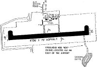
| A58-25 | RY 25 +9 FT FENCE AND BERM, 0 FT FM RY END, 250 FT L. |
| A81-APT | ACTVT REIL RWY 07; PAPI RWY 07; MIRL RWY 07/25 - CTAF; 3 CLICKS MED INTST - 5 CLICKS HI INTST. |
| E111 | ESTABD PRIOR TO 1959. |
Runways
Runway Summary
| Runways: | 07/25 |
| Longest Runway: | 07/25 is 5371 ft (1637 m) long |
| Runways with an Instrument Approach: |
GNG Airport Runway Details
| Runway 07/25 | 5371 ft x 75 ft (1637 m x 23 m) | |
| Runway Length Source: | 3RD PARTY SURVEY as of 06/02/2021 | |
| Surface: | Asphalt - Good condition - No special surface treatment | |
| Runway Edge Lights: | Medium Intensity | |
Runway Weight Bearing Capacity (in thousands of pounds) |
||
| Single Wheel Landing Gear: | 30.0 | |
Runway 07 |
Runway 25 |
|
Elevation: |
3656.8 | 3732.3 |
Latitude: |
42-54-58.8256N | 42-55-04.1541N |
Longitude: |
114-46-34.7148W | 114-45-22.9174W |
|
Runway True Alignment: |
084 | 264 |
Glide Path Angle: |
2.8 degrees | 0.0 degrees |
Traffic Pattern: |
Left | Left |
Runway Markings Type: |
Nonprecision Instrument | Nonprecision Instrument |
Runway Markings Condition: |
Good | Good |
Visual Glide Slope Indicators: |
2-Light PAPI On Left Side Of Runway | |
REIL: |
Yes | No |
Threshold Crossing Height: |
40 |
Services
Airframe Repair: |
Major |
Powerplant Repair: |
Major |
Bottled Oxygen: |
None |
Fuel Available: |
100, Jet A |
Landing Fees: |
No |
Parking: |
Tiedowns available |
Maps & Diagrams
GNG Sectional
Flight Planning
at skyvector.com
at skyvector.com