Location
Latitude: |
31-49-53.7000N (31.831583) |
Longitude: |
094-09-23.1000W (-94.156417) |
Elevation: |
318.6 feet MSL (97 m MSL) |
Magnetic Variation: |
1.1 E (as of April 2024 from WMM2020 model) |
Time Zone: |
UTC -6.0 (Standard Time) UTC -5.0 (Daylight Savings Time) |
From City: |
03 N.M. NE of Center, Texas |
Found On: |
Houston Chart |
FAA Region: |
ASW |
Contacts
Manager: |
Publicly owned: |
| CHAD NEHRING PO BOX 1744 CENTER, TX 75935 936-598-8119 |
CITY OF CENTER PO BOX 1744 CENTER, TX 75935 936-598-2941 |
Operations
Airport Status: |
Operational |
Facility Use: |
Public |
Type: |
Airport |
Activation Date: |
02/1949 |
Control tower: |
No |
Attendance (Months/Days/Hours): |
Months/Days/Hours ALL/MON-FRI/0800-1500 |
Boundary ARTCC: |
ZFW (Fort Worth) |
Responsible ARTCC: |
ZFW (Fort Worth) |
Lighting Schedule: |
SEE RMK |
Segmented Circle Indicator: |
Yes |
Traffic Pattern Altitude (MSL): |
1319 feet (402 m) |
NOTAMs Facility: |
F17 |
NOTAM-D Service: |
Yes |
International Airport of Entry: |
No |
Customs Landing Rights: |
No |
Military Landing Rights: |
Yes |
Civil/Military Joint Use: |
No |
Based Aircraft
| Single Engine: | 24 |
| Multi Engine: | 1 |
| Jet Engine: | 3 |
| GA Helicopters: | 4 |
Annual Operations (as of 10/05/2022)
| Total Operations: | 12330 | |
| GA Local: | 7380 | 59.9% |
| GA Itinerant: | 4920 | 39.9% |
| Military Aircraft: | 30 | 0.2% |
Communications
| CTAF: | 122.800 |
| Unicom: | 122.800 |
| AWOS-3PT: | 128.775 (936-598-3355) |
- APCH/DEP CTL SVC PRVDD BY FORT WORTH ARTCC (ZFW) ON FREQS 126.325/346.25 (SHREVEPORT RCAG).
Fixed Based Operators (FBOs) & Fuel
(Click on a business for detail)
Please help us keep this information up to date. This is a FREE SERVICE just like everything else on Airport Guide! If you see that a business needs to be added, modified, or deleted please fill out our Update Form.
To add, modify, or delete a business click here.
Please help us keep this information up to date. This is a FREE SERVICE just like everything else on Airport Guide! If you see that a business needs to be added, modified, or deleted please fill out our Update Form.
Area Code: 409 |
| Business Name | Frequency | Phone | Fuel Grade |
|---|---|---|---|
| City of Center
Update FBO info |
Unicom 122.8 | 598-8119 | 100LL, Jet A |
Flight Service Stations
| Primary | Alternate | |
| FSS on Field: | N | |
| FSS Name (ID): | Montgomery County(CXO) | |
| Frequency: | ||
| Toll Free Phone: | 1-800-WX-BRIEF |
Instrument Procedures / Charts
FAA Terminal Procedures valid from 0901Z 03/21/24 to 0901Z 04/18/24.
There are various types of charts available for an airport. They are listed in the Page Type column. Here is a legend for those types:
APD - Airport Diagram
DP - Departure Procedure Charts
HOT - Hot Spots
IAP - Instrument Approach Procedure Charts
MIN - Minimums
STAR - Standard Terminal Arrival Charts
| Page Type | Page Name | Volume | Action Since Last Cycle |
|---|---|---|---|
| IAP | NDB RWY 17 | SC-5 | |
| IAP | RNAV (GPS) RWY 17 | SC-5 | |
| IAP | RNAV (GPS) RWY 35 | SC-5 | |
| MIN | TAKEOFF MINIMUMS | SC-5 |
Terminal Procedures are only available for airports in several countries with more being added all the time. If you are looking for a specific country's charts, please send an email to support(at)airportguide.com stating the country name. This will be used to prioritize the implementation.
Navigation Aids (Navaids) near F17
| Dist (NM) | ID | Morse Code | Name | Type | Freq | True Hdg | Mag Hdg |
|---|---|---|---|---|---|---|---|
| 0.2 | CZJ | _ . _ . _ _ . . . _ _ _ | Amason | NDB | 341 | 59 | 58 |
| 22.1 | RPF | . _ . . _ _ . . . _ . | Carthage | NDB | 332 | 341 | 340 |
| 24.4 | MSD | _ _ . . . _ . . | Mansfield | NDB | 414 | 54 | 53 |
| 30.1 | GXD | _ _ . _ . . _ _ . . | Nacogdoches | NDB | 391 | 248 | 247 |
| 35.1 | MMY | _ _ _ _ _ . _ _ | Many | NDB | 272 | 116 | 115 |
| 35.5 | OC | _ _ _ _ . _ . | Nados | NDB | 253 | 234 | 233 |
| 40.4 | SHV | . . . . . . . . . . _ | Shreveport | VOT | 108.20 | 23 | 22 |
| 41.7 | HNO | . . . . _ . _ _ _ | Henderson | NDB | 371 | 300 | 299 |
| 44.5 | EMG | . _ _ _ _ . | Elm Grove | VORTAC | 111.20 | 39 | 38 |
| 46.4 | GGG | _ _ . _ _ . _ _ . | Gregg County | VORTAC | 112.90 | 319 | 318 |
| 47.3 | BAD | _ . . . . _ _ . . | Barksdale | TACAN | 115.80 | 31 | 30 |
| 47.4 | DTN | _ . . _ _ . | Downtown | VOR | 108.60 | 26 | 25 |
| 49.3 | LFK | . _ . . . . _ . _ . _ | Lufkin | VORTAC | 112.10 | 215 | 214 |
| 49.6 | GG | _ _ . _ _ . | Veels | NDB | 410 | 319 | 318 |
| 50.2 | LF | . _ . . . . _ . | Flufy | NDB | 350 | 223 | 222 |
| 54.0 | JSO | . _ _ _ . . . _ _ _ | Cherokee County | NDB | 263 | 272 | 271 |
| 56.0 | OOC | _ _ _ _ _ _ _ . _ . | Natchitoches | NDB | 407 | 100 | 99 |
| 59.1 | EIC | . . . _ . _ . | Belcher | VORTAC | 117.40 | 17 | 16 |
| 60.4 | VED | . . . _ . _ . . | Leesville | NDB | 247 | 136 | 135 |
| 62.1 | VIV | . . . _ . . . . . _ | Vivian | NDB | 284 | 6 | 5 |
Nearby Airports with Fuel
Notices to Airmen (NOTAMS)
Remarks
| A110-2 | DEER ON & INVOF ARPT. |
| A110-3 | FOR CD IF UNA TO CTC ON FSS FREQ, CTC FORT WORTH ARTCC AT 817-858-7584. |
| A14 | CITY/AMGR. |
| A15 | ARPT PHYS ADS 397 FM 1656. |
| A16 | EMERGENCY PHONE: 936-598-2788, POLICE DISPATCH. |
| A58-17 | 15 FT BRUSH, 0-200 FT DSTC, 214- 249 FT R. |
| A70-FUEL-10 | 0LL SELF SVC FUEL. |
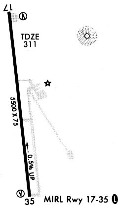
| A81-APT | MIRL RWY 17/35 PRESET LOW INTST; TO INCR INTST ACTVT - CTAF. |
Runways
Runway Summary
| Runways: | 17/35 |
| Longest Runway: | 17/35 is 5501 ft (1677 m) long |
| Runways with an Instrument Approach: |
F17 Airport Runway Details
| Runway 17/35 | 5501 ft x 75 ft (1677 m x 23 m) | |
| Runway Length Source: | 3RD PARTY SURVEY as of 09/22/2011 | |
| Surface: | Asphalt - Good condition - No special surface treatment | |
| Runway Edge Lights: | Medium Intensity | |
Runway Weight Bearing Capacity (in thousands of pounds) |
||
| Single Wheel Landing Gear: | 30.0 | |
Runway 17 |
Runway 35 |
|
Elevation: |
318.5 | 290.9 |
Latitude: |
31-50-20.5932N | 31-49-26.8954N |
Longitude: |
094-09-28.3715W | 094-09-17.8822W |
|
Runway True Alignment: |
171 | 351 |
Glide Path Angle: |
3.0 degrees | 3.0 degrees |
Runway Markings Type: |
Nonprecision Instrument | Nonprecision Instrument |
Runway Markings Condition: |
Good | Good |
Object at End: |
TREES | TREES |
Object Height: |
18 | 46 |
Distance from End: |
201 | 824 |
Object Centerline Offset: |
249 ft. right of centerline | 230 ft. right of centerline |
Visual Glide Slope Indicators: |
2-Light PAPI On Left Side Of Runway | 2-Light PAPI On Left Side Of Runway |
Threshold Crossing Height: |
50 | 49 |
Services
Airframe Repair: |
Major |
Powerplant Repair: |
Major |
Bottled Oxygen: |
High Pressure / Low Pressure |
Bulk Oxygen: |
None |
Fuel Available: |
100LL, Jet A |
Landing Fees: |
No |
Parking: |
Hangars and tiedowns available |
Maps & Diagrams
F17 Sectional
Flight Planning
at skyvector.com
at skyvector.com