Location
Latitude: |
46-07-12.8174N (46.120227) |
Longitude: |
089-52-55.9199W (-89.8822) |
Elevation: |
1610.3 feet MSL (491 m MSL) |
Magnetic Variation: |
2.9 W (as of April 2024 from WMM2020 model) |
Time Zone: |
UTC -6.0 (Standard Time) UTC -5.0 (Daylight Savings Time) |
From City: |
01 N.M. S of Manitowish Waters, Wisconsin |
Found On: |
Green Bay Chart |
FAA Region: |
AGL |
Contacts
Manager: |
Publicly owned: |
| JOHN HANSON P.O. BOX 267 MANITOWISH WATERS, WI 54545 715-904-0502 |
TOWN OF MANITOWISH WATERS P O BOX 267 MANITOWISH WATERS, WI 54545 715-543-8400 |
Operations
Airport Status: |
Operational |
Facility Use: |
Public |
Type: |
Airport |
Activation Date: |
10/1945 |
Control tower: |
No |
Attendance (Months/Days/Hours): |
Months/Days/Hours Unattended |
Boundary ARTCC: |
ZMP (Minneapolis) |
Responsible ARTCC: |
ZMP (Minneapolis) |
Lighting Schedule: |
SEE RMK |
Segmented Circle Indicator: |
Yes |
Traffic Pattern Altitude (MSL): |
2610 feet (796 m) |
NOTAMs Facility: |
GRB |
NOTAM-D Service: |
Yes |
International Airport of Entry: |
No |
Customs Landing Rights: |
No |
Military Landing Rights: |
No |
Civil/Military Joint Use: |
No |
Based Aircraft
| Single Engine: | 19 |
Annual Operations (as of 08/12/2021)
| Total Operations: | 6200 | |
| Air Taxi: | 200 | 3.2% |
| GA Local: | 3000 | 48.4% |
| GA Itinerant: | 3000 | 48.4% |
Communications
| CTAF: | 122.800 |
| Unicom: | 122.800 |
| AWOS-3PT: | 118.175 (715-543-2004) |
- APCH/DEP SVC PRVDD BY MINNEAPOLIS ARTCC ON FREQS 133.65/281.5 (RHINELANDER RCAG).
Fixed Based Operators (FBOs) & Fuel
(Click on a business for detail)
Please help us keep this information up to date. This is a FREE SERVICE just like everything else on Airport Guide! If you see that a business needs to be added, modified, or deleted please fill out our Update Form.
To add, modify, or delete a business click here.
Please help us keep this information up to date. This is a FREE SERVICE just like everything else on Airport Guide! If you see that a business needs to be added, modified, or deleted please fill out our Update Form.
Area Code: 715 |
| Business Name | Frequency | Phone | Fuel Grade |
|---|---|---|---|
| Manitowish Waters Airport
Update FBO info |
543-8320, -2129 | 100LL |
Flight Service Stations
| Primary | Alternate | |
| FSS on Field: | N | |
| FSS Name (ID): | Green Bay(GRB) | |
| Frequency: | ||
| Toll Free Phone: | 1-800-WX-BRIEF |
Instrument Procedures / Charts
FAA Terminal Procedures valid from 0901Z 03/21/24 to 0901Z 04/18/24.
There are various types of charts available for an airport. They are listed in the Page Type column. Here is a legend for those types:
APD - Airport Diagram
DP - Departure Procedure Charts
HOT - Hot Spots
IAP - Instrument Approach Procedure Charts
MIN - Minimums
STAR - Standard Terminal Arrival Charts
| Page Type | Page Name | Volume | Action Since Last Cycle |
|---|---|---|---|
| IAP | RNAV (GPS) RWY 14 | EC-3 | |
| IAP | RNAV (GPS) RWY 32 | EC-3 | |
| MIN | TAKEOFF MINIMUMS | EC-3 |
Terminal Procedures are only available for airports in several countries with more being added all the time. If you are looking for a specific country's charts, please send an email to support(at)airportguide.com stating the country name. This will be used to prioritize the implementation.
Navigation Aids (Navaids) near D25
| Dist (NM) | ID | Morse Code | Name | Type | Freq | True Hdg | Mag Hdg |
|---|---|---|---|---|---|---|---|
| 9.5 | BDJ | _ . . . _ . . . _ _ _ | Boulder Junction | NDB | 206 | 84 | 87 |
| 13.3 | ARV | . _ . _ . . . . _ | Arbor Vitae | NDB | 221 | 151 | 154 |
| 18.3 | DO | _ . . _ _ _ | Dougy | NDB | 236 | 159 | 162 |
| 24.8 | PKF | . _ _ . _ . _ . . _ . | Park Falls | NDB | 371 | 246 | 249 |
| 26.7 | IWD | . . . _ _ _ . . | Ironwood | VOR-DME | 108.80 | 337 | 340 |
| 27.0 | RXW | . _ . _ . . _ . _ _ | Watersmeet | NDB | 407 | 67 | 70 |
| 28.0 | LNL | . _ . . _ . . _ . . | Land O Lakes | NDB | 396 | 86 | 89 |
| 31.5 | RH | . _ . . . . . | Arsha | NDB | 272 | 159 | 162 |
| 33.4 | PBH | . _ _ . _ . . . . . . . | Phillips | NDB | 263 | 221 | 224 |
| 34.1 | RHI | . _ . . . . . . . | Rhinelander | VOR-DME | 109.20 | 148 | 151 |
| 48.7 | OGM | _ _ _ _ _ . _ _ | Ontonagon | NDB | 375 | 25 | 28 |
| 50.0 | ASX | . _ . . . _ . . _ | Ashland | VOR-DME | 110.20 | 301 | 304 |
| 55.8 | RRL | . _ . . _ . . _ . . | Merrill | NDB | 257 | 172 | 175 |
| 59.7 | RCX | . _ . _ . _ . _ . . _ | Rusk County | NDB | 356 | 231 | 233 |
| 63.5 | MDZ | _ _ _ . . _ _ . . | Medford | NDB | 335 | 196 | 199 |
| 65.4 | HYR | . . . . _ . _ _ . _ . | Hayward | DME | 113.4 | 265 | 267 |
| 66.1 | AIG | . _ . . _ _ . | Antigo | NDB | 347 | 150 | 153 |
| 72.4 | FZK | . . _ . _ _ . . _ . _ | Wausau | NDB | 243 | 171 | 174 |
| 76.0 | IMT | . . _ _ _ | Iron Mountain | VOR-DME | 111.20 | 103 | 107 |
| 77.4 | AUW | . _ . . _ . _ _ | Wausau | VOR-DME | 111.60 | 170 | 173 |
Nearby Airports with Fuel
Notices to Airmen (NOTAMS)
Remarks
| A110-1 | 122 FT AGL/1737 FT MSL TWR APRXLY 1000 FT E OF ARPT. |
| A110-2 | DEER & COYOTES ON & INVOF ARPT. |
| A110-4 | BIRDS AND MIGRATORY WATERFOWL ON & INVOF ARPT. |
| A110-5 | FOR CD CTC MINNEAPOLIS ARTCC AT 651-463-5588. |
| A110-6 | USE UNICOM FREQ ON KEYPAD TO OPEN AIRSIDE TRML DOOR. |
| A30-04/22 | CLSD IN WINTER. |
| A42-04 | 04/22 MRKD WITH YELLOW CONES. |
| A70-FUEL-10 | 0LL 100LL AVBL 24 HRS WITH CREDIT CARD. |
| A81-APT | MIRL RY 14/32 PRESET ON LOW INTST; TO INCR INTST& ACTVT PAPI RY 14 & 32; MIRL RY 14/32; REIL RY 14/32 - CTAF. |
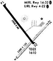
Runways
Runway Summary
| Runways: | 04/22 14/32 |
| Longest Runway: | 14/32 is 3498 ft (1066 m) long |
| Runways with an Instrument Approach: |
D25 Airport Runway Details
| Runway 04/22 | 3094 ft x 120 ft (943 m x 37 m) | |
| Runway Length Source: | 3RD PARTY SURVEY as of 10/04/2009 | |
| Surface: | Turf - Good condition - No special surface treatment | |
Runway 04 |
Runway 22 |
|
Elevation: |
1607.6 | 1609.8 |
Latitude: |
46-06-56.0990N | 46-07-18.3991N |
Longitude: |
089-53-02.5887W | 089-52-32.5773W |
|
Runway True Alignment: |
043 | 223 |
Glide Path Angle: |
0.0 degrees | 0.0 degrees |
Traffic Pattern: |
Left | Left |
Runway Markings Type: |
None | None |
Object at End: |
TREES | TREES |
Object Height: |
36 | 125 |
Distance from End: |
470 | 1800 |
Object Centerline Offset: |
150 ft. left of centerline | 130 ft. left of centerline |
REIL: |
No | No |
Touchdown Lights: |
No | No |
Centerline Lights: |
No | No |
| Runway 14/32 | 3498 ft x 60 ft (1066 m x 18 m) | |
| Runway Length Source: | 3RD PARTY SURVEY as of 10/04/2009 | |
| Surface: | Turf - Good condition - No special surface treatment | |
| Runway Edge Lights: | Medium Intensity | |
Runway Weight Bearing Capacity (in thousands of pounds) |
||
| Single Wheel Landing Gear: | 12.5 | |
Runway 14 |
Runway 32 |
|
Elevation: |
1609.6 | 1610.2 |
Latitude: |
46-07-31.2094N | 46-07-04.2757N |
Longitude: |
089-53-18.8270W | 089-52-47.7607W |
|
Runway True Alignment: |
141 | 321 |
Glide Path Angle: |
3.5 degrees | 3.5 degrees |
Runway Markings Type: |
Nonprecision Instrument | Nonprecision Instrument |
Runway Markings Condition: |
Good | Good |
Object at End: |
TREES | TREES |
Object Height: |
60 | 70 |
Distance from End: |
1310 | 1575 |
Object Centerline Offset: |
150 ft. left of centerline | 130 ft. left of centerline |
Visual Glide Slope Indicators: |
2-Light PAPI On Left Side Of Runway | 2-Light PAPI On Left Side Of Runway |
REIL: |
Yes | Yes |
Threshold Crossing Height: |
40 | 43 |
Services
Airframe Repair: |
Major |
Powerplant Repair: |
Major |
Bottled Oxygen: |
High Pressure |
Bulk Oxygen: |
High Pressure |
Fuel Available: |
100LL, Jet A+ |
Parking: |
Hangars and tiedowns available |
Maps & Diagrams
D25 Sectional
Flight Planning
at skyvector.com
at skyvector.com