
Location
Latitude: |
38-22-33.6470N (38.376013) |
Longitude: |
081-35-34.4170W (-81.592894) |
Elevation: |
947.1 feet MSL (289 m MSL) |
Magnetic Variation: |
7.9 W (as of April 2024 from WMM2020 model) |
Time Zone: |
UTC -5.0 (Standard Time) UTC -4.0 (Daylight Savings Time) |
From City: |
03 N.M. E of Charleston, West Virginia |
Found On: |
Cincinnati Chart |
FAA Region: |
AEA |
Contacts
Manager: |
Publicly owned: |
| MS DOMINIQUE RANIERI, ESQ., C.M. 100 AIRPORT ROAD SUITE 175 CHARLESTON, WV 25311 304-344-8033 |
CENTRAL WV REG ARPT AUTH 100 AIRPORT ROAD SUITE 175 CHARLESTON, WV 25311 (304) 344-8033 |
Operations
Airport Status: |
Operational |
Facility Use: |
Public |
Type: |
Airport |
Activation Date: |
08/1947 |
Control tower: |
Yes |
Attendance (Months/Days/Hours): |
Months/Days/Hours ALL/ALL/ALL |
Boundary ARTCC: |
ZID (Indianapolis) |
Responsible ARTCC: |
ZID (Indianapolis) |
Segmented Circle Indicator: |
No |
Traffic Pattern Altitude (MSL): |
1947 feet (593 m) |
NOTAMs Facility: |
CRW |
NOTAM-D Service: |
Yes |
International Airport of Entry: |
No |
Customs Landing Rights: |
Yes |
Military Landing Rights: |
Yes |
Civil/Military Joint Use: |
No |
Aircraft Rescue and Firefighting: |
Class I ARFF Index: B Air Carrier Service: Scheduled Certification Date: 05/1973 |
Based Aircraft
| Single Engine: | 25 |
| Multi Engine: | 11 |
| Jet Engine: | 3 |
| GA Helicopters: | 11 |
| Military Aircraft: | 8 |
Annual Operations (as of 12/31/2023)
| Total Operations: | 48078 | |
| Commercial: | 5517 | 11.5% |
| Air Taxi: | 8754 | 18.2% |
| GA Local: | 16691 | 34.7% |
| GA Itinerant: | 12975 | 27.0% |
| Military Aircraft: | 4141 | 8.6% |
Communications
| Unicom: | 122.950 |
| Tower: | CHARLESTON 125.7 257.8 Hrs: 24 |
| Clearance Del.: | 118.55 |
| Ground: | 121.8 348.6 |
| Approach: | CHARLESTON 119.2 ;SOUTH 124.1 ;NORTH 269.125 Hrs: 24 128.5 |
| Departure: | CHARLESTON 119.2 ;SOUTH 124.1 ;NORTH 269.125 Hrs: 24 128.5 |
| ATIS: | 127.6 Hrs: 24 |
| ASOS: | (304-346-4797) |
| EMERG: | 243.0 |
| CLASS C: | 119.2 ;SOUTH |
| EMERG: | 121.5 |
| CLASS C: | 269.125 |
| CLASS C: | 124.1 ;NORTH |
Fixed Based Operators (FBOs) & Fuel
(Click on a business for detail)
Please help us keep this information up to date. This is a FREE SERVICE just like everything else on Airport Guide! If you see that a business needs to be added, modified, or deleted please fill out our Update Form.
To add, modify, or delete a business click here.
Please help us keep this information up to date. This is a FREE SERVICE just like everything else on Airport Guide! If you see that a business needs to be added, modified, or deleted please fill out our Update Form.
Area Code: 304 |
| Business Name | Frequency | Phone | Fuel Grade |
|---|
Flight Service Stations
| Primary | Alternate | |
| FSS on Field: | N | |
| FSS Name (ID): | Elkins(EKN) | |
| Frequency: | ||
| Toll Free Phone: | 1-800-WX-BRIEF |
Instrument Procedures / Charts
FAA Terminal Procedures valid from 0901Z 03/21/24 to 0901Z 04/18/24.
There are various types of charts available for an airport. They are listed in the Page Type column. Here is a legend for those types:
APD - Airport Diagram
DP - Departure Procedure Charts
HOT - Hot Spots
IAP - Instrument Approach Procedure Charts
MIN - Minimums
STAR - Standard Terminal Arrival Charts
| Page Type | Page Name | Volume | Action Since Last Cycle |
|---|---|---|---|
| APD | AIRPORT DIAGRAM | NE-4 | |
| IAP | ILS OR LOC RWY 05 | NE-4 | |
| IAP | ILS OR LOC RWY 23 | NE-4 | |
| IAP | RNAV (GPS) Y RWY 05 | NE-4 | |
| IAP | RNAV (GPS) Y RWY 23 | NE-4 | |
| IAP | RNAV (RNP) Z RWY 05 | NE-4 | |
| IAP | RNAV (RNP) Z RWY 23 | NE-4 | |
| IAP | VOR-A | NE-4 | |
| MIN | ALTERNATE MINIMUMS | NE-4 | |
| MIN | TAKEOFF MINIMUMS | NE-4 |
Terminal Procedures are only available for airports in several countries with more being added all the time. If you are looking for a specific country's charts, please send an email to support(at)airportguide.com stating the country name. This will be used to prioritize the implementation.
Navigation Aids (Navaids) near CRW
| Dist (NM) | ID | Morse Code | Name | Type | Freq | True Hdg | Mag Hdg |
|---|---|---|---|---|---|---|---|
| 0.2 | CRW | _ . _ . . _ . . _ _ | Charleston | VOT | 108.80 | 184 | 192 |
| 8.5 | HVQ | . . . . . . . _ _ _ . _ | Charleston | VOR-DME | 117.40 | 259 | 267 |
| 30.5 | HNN | . . . . _ . _ . | Henderson | DME | 115.9 | 318 | 326 |
| 38.6 | GTC | _ _ . _ _ . _ . | Guyandot | NDB | 293 | 202 | 210 |
| 42.1 | BKW | _ . . . _ . _ . _ _ | Beckley | VOR-DME | 117.70 | 148 | 156 |
| 44.2 | RNL | . _ . _ . . _ . . | Rainelle | VOR | 116.60 | 122 | 130 |
| 52.9 | PK | . _ _ . _ . _ | Versi | NDB | 388 | 5 | 13 |
| 58.3 | UNI | . . _ _ . . . | Athens | FAN MARKER | 331 | 339 | |
| 58.5 | UGS | . . _ _ _ . . . . | University | NDB | 250 | 334 | 342 |
| 61.1 | PKB | . _ _ . _ . _ _ . . . | Marietta Ohio | FAN MARKER | 7 | 15 | |
| 63.4 | ECB | . _ . _ . _ . . . | Newcombe | DME | 110.4 | 258 | 265 |
| 63.9 | LW | . _ . . . _ _ | Bushi | NDB | 346 | 123 | 131 |
| 64.5 | LWB | . _ . . . _ _ _ . . . | Greenbrier | DME | 116.05 | 118 | 126 |
| 64.7 | JPU | . _ _ _ . _ _ . . . _ | Parkersburg | VOR-DME | 114.45 | 8 | 16 |
| 66.9 | BLF | _ . . . . _ . . . . _ . | Bluefield | VOR-DME | 115.05 | 163 | 171 |
| 67.0 | YRK | _ . _ _ . _ . _ . _ | York | VORTAC | 112.80 | 284 | 292 |
| 77.1 | EKN | . _ . _ _ . | Elkins | VORTAC | 114.20 | 64 | 72 |
| 78.6 | EOP | . _ _ _ . _ _ . | Waverly | NDB | 385 | 307 | 315 |
| 81.3 | CKB | _ . _ . _ . _ _ . . . | Clarksburg | VOR-DME | 112.60 | 49 | 57 |
| 87.0 | RQY | . _ . _ _ . _ _ . _ _ | Randolph County | NDB | 284 | 68 | 77 |
Nearby Airports with Fuel
Notices to Airmen (NOTAMS)
Remarks
| A110-1 | DEER & BIRDS ON & INVOF ARPT. |
| A110-10 | RWY 23 ENGINEERED MATERIALS ARRESTING SYSTEM (EMAS) 328 FT IN LENGTH BY 170 FT IN WIDTH LCTD AT THE DER. |
| A110-7 | ANG: AFLD MGMT OPS OPR 1200-2100Z++ MON-FRI, AND UNIT TRNG ASSEMBLY (UTA) WKND. PPR REQ FOR ALL ACFT 48 HR PRIOR FOR SVCG AND USE OF PARK RAMPS. FILE PPR NR IN RMK SEC ON FLT PLAN. CLSD SAT-SUN AND HOL. AVBL WKND FOR OBO, CTC AFLD MGMT OPS DSN 366-6240/6200, C304-341-6240/6200. ACFT MUST MEET PPR TIME +/- 1 HR OR WILL BE CONSDR CNXED, UPDATE CHNG AFTER HR CALL DSN 366-6301 OR C304-341-6301. NSTD PAVEMENT MRK ON ANG RAMP. COMD POST DSN 366-6250/6256, C304-341-6250/6256. EXPLOSIVES PROH. |
| A110-8 | FUEL SERVICE-CAPITAL JET CENTER CTC 304-346--9977. |
| A110-9 | SERVICE-FUEL: A++(MIL). |
| A24 | LNDG FEE NOT APPLICABLE TO BASED ACFT. |
| A42-23 | RWY 23 MIL ASSAULT LDG ZONE AND PRECISION INSTR MARKINGS. |
| E111 | PRIOR TO 1959. |
| E60-23 | ENGINEERED MATERIAL ARRESTING SYSTEM (EMAS) 328 FT IN LENGTH BY 170 FT IN WIDTH LCTD AT THE DER 23. |
Runways
Runway Summary
| Runways: | 05/23 |
| Longest Runway: | 05/23 is 6715 ft (2047 m) long |
| Runways with an Instrument Approach: | 05, 23 |
CRW Airport Runway Details
| Runway 05/23 | 6715 ft x 150 ft (2047 m x 46 m) | |
| Runway Length Source: | 3RD PARTY SURVEY as of 07/23/2018 | |
| Surface: | Asphalt - Good condition - Saw-cut or plastic grooved | |
| Runway Pavement Class: | 43 /F/A/W/T | |
| Runway Edge Lights: | High Intensity | |
Runway Weight Bearing Capacity (in thousands of pounds) |
||
| Single Wheel Landing Gear: | 120.0 | |
| Dual Wheel Landing Gear: | 160.0 | |
| Dual Tandem Wheel Landing Gear: | 260.0 | |
Runway 05 |
Runway 23 |
|
Elevation: |
946.6 | 894.1 |
Latitude: |
38-22-11.0700N | 38-22-56.2209N |
Longitude: |
081-36-05.3200W | 081-35-03.5088W |
|
Runway True Alignment: |
047 | 227 |
ILS Type: |
ILS/DME | ILS/DME |
Glide Path Angle: |
3.0 degrees | 3.0 degrees |
Traffic Pattern: |
Left | Left |
Runway Markings Type: |
Precision Instrument | Nonstandard (other than numbers only) |
Runway Markings Condition: |
Good | Good |
Arresting Device: |
EMAS | |
Object at End: |
POLE | POLE |
Object Height: |
223 | 136 |
Object Marked/Lighted?: |
Lighted | Lighted |
Distance from End: |
3950 | 4300 |
Object Centerline Offset: |
950 ft. right of centerline | 100 ft. left of centerline |
Visual Glide Slope Indicators: |
4-Light PAPI On Left Side Of Runway | 4-Box VASI On Right Side Of Runway |
Runway Visual Range (RVR): |
Touchdown, Rollout | Touchdown, Rollout |
Approach Light System: |
Standard 2,400 Foot High Intensity Approach Lighting System With Sequenced Flashers, Cat. I Config. | |
REIL: |
Yes | |
Centerline Lights: |
Yes | Yes |
Threshold Crossing Height: |
56 | 56 |
Threshold Elevation: |
897.1 | |
Displaced Threshold: |
500 | |
Threshold Latitude: |
38-22-52.8578N | |
Threshold Longitude: |
081-35-08.1174W | |
Declared Distances |
||
Take Off Run Avbl. (TORA): |
6715 | 6715 |
Take Off Distance Avbl. (TODA): |
6715 | 6715 |
Actual Stop Dist. Avbl. (ASDA): |
6215 | 6715 |
Landing Dist. Avbl. (LDA): |
6215 | 6215 |
Services
Airframe Repair: |
Major |
Powerplant Repair: |
Major |
Bottled Oxygen: |
None |
Bulk Oxygen: |
None |
Fuel Available: |
100LL |
Landing Fees: |
No |
Parking: |
Tiedowns available |
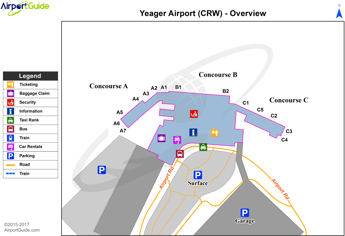
Maps & Diagrams
CRW Sectional
Flight Planning
at skyvector.com
at skyvector.com
