Location
Latitude: |
64-04-00.3050N (64.066751) |
Longitude: |
141-57-04.8500W (-141.951347) |
Elevation: |
1640.0 feet MSL (500 m MSL) |
Magnetic Variation: |
17.6 E (as of April 2024 from WMM2020 model) |
Time Zone: |
UTC -9.0 (Standard Time) UTC -8.0 (Daylight Savings Time) |
From City: |
00 N.M. SW of Chicken, Alaska |
Found On: |
Dawson Chart |
FAA Region: |
AAL |
Contacts
Manager: |
Publicly owned: |
| SAM JENNINGS P.O. BOX 356 TOK, AK 99780 907-883-5128 |
ALASKA DOT&PF NORTHERN REGION 2301 PEGER RD FAIRBANKS, AK 99709 907-451-2200 |
Operations
Airport Status: |
Operational |
Facility Use: |
Public |
Type: |
Airport |
Activation Date: |
11/1949 |
Control tower: |
No |
Attendance (Months/Days/Hours): |
Months/Days/Hours Unattended |
Boundary ARTCC: |
ZAN (Anchorage) |
Responsible ARTCC: |
ZAN (Anchorage) |
Segmented Circle Indicator: |
Yes |
Traffic Pattern Altitude (MSL): |
2640 feet (805 m) |
NOTAMs Facility: |
ORT |
NOTAM-D Service: |
Yes |
International Airport of Entry: |
No |
Customs Landing Rights: |
No |
Military Landing Rights: |
No |
Civil/Military Joint Use: |
No |
Based Aircraft
Annual Operations (as of 12/31/2021)
| Total Operations: | 475 | |
| Air Taxi: | 125 | 26.3% |
| GA Local: | 300 | 63.2% |
| GA Itinerant: | 50 | 10.5% |
Communications
| CTAF: | 122.800 |
| Unicom: | 122.800 |
Fixed Based Operators (FBOs) & Fuel
(Click on a business for detail)
Please help us keep this information up to date. This is a FREE SERVICE just like everything else on Airport Guide! If you see that a business needs to be added, modified, or deleted please fill out our Update Form.
To add, modify, or delete a business click here.
Please help us keep this information up to date. This is a FREE SERVICE just like everything else on Airport Guide! If you see that a business needs to be added, modified, or deleted please fill out our Update Form.
Area Code: 907 |
| Business Name | Frequency | Phone | Fuel Grade |
|---|
Flight Service Stations
| Primary | Alternate | |
| FSS on Field: | N | |
| FSS Name (ID): | Northway(ORT) | Fairbanks (FAI) |
| Frequency: | ||
| Toll Free Phone: | 1-800-478-6611 | 1-866-248-6516 |
Instrument Procedures / Charts
Terminal Procedures are only available for airports in several countries with more being added all the time. If you are looking for a specific country's charts, please send an email to support(at)airportguide.com stating the country name. This will be used to prioritize the implementation.
Navigation Aids (Navaids) near CKX
| Dist (NM) | ID | Morse Code | Name | Type | Freq | True Hdg | Mag Hdg |
|---|---|---|---|---|---|---|---|
| 67.1 | AES | . _ . . . . | Nabesna | NDB | 390 | 179 | 161 |
| 67.2 | ORT | _ _ _ . _ . _ | Northway | VORTAC | 116.30 | 179 | 161 |
| 73.1 | DA | Dawson City | NDB | 214 | 90 | 72 | |
| 98.1 | DJN | _ . . . _ _ _ _ . | Delta Junction | NDB | 347 | 270 | 253 |
| 99.0 | BIG | _ . . . . . _ _ . | Big Delta | VORTAC | 114.90 | 269 | 252 |
Nearby Airports with Fuel
| Dist (NM) | Name (Airport IDs) | True Hdg | Mag Hdg | Fuel Grade |
|---|---|---|---|---|
| 51.6 | Tok Junction Airport (TKJ PFTO 6K8) |
211 | 194 | 100LL, Jet A |
| 66.3 | Northway Airport (ORT PAOR ORT) |
179 | 162 | 100LL, Jet A |
Notices to Airmen (NOTAMS)
Remarks
| A110-1 | RY COND NOT MONITORED; RECOMMEND VISUAL INSPECTION PRIOR TO LANDING. |
| A110-10 | WATERFOWL ON & INVOF RY DURING SUMMER. |
| A110-11 | RY 13/31 THLDS MKD WITH THLD PANELS & CONES. |
| A110-2 | FIRE CREWS AND HELICOPTERS WORK OUT OF ARPT IN SUMMER. |
| A110-3 | SNOW REMOVAL OPERATIONS DURING WINTER--MONITOR CTAF. |
| A110-5 | SUAIS - 125.3/126.3(1-800-758-8723). |
| A110-7 | EXPECT TURBULENCE DURING APPROACH ON WINDY DAYS. |
| A110-9 | RY 13/31 DIPS IN CENTER & SLOPES UPWARDS TO BOTH ENDS. |
Runways
Runway Summary
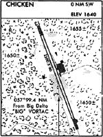
| Runways: | 13/31 |
| Longest Runway: | 13/31 is 2500 ft (762 m) long |
| Runways with an Instrument Approach: |
CKX Airport Runway Details
| Runway 13/31 | 2500 ft x 60 ft (762 m x 18 m) | |
| Runway Length Source: | ADO as of 03/11/2014 | |
| Surface: | Gravel/Dirt - Good condition - No special surface treatment | |
Runway 13 |
Runway 31 |
|
Elevation: |
1640.0 | 1640.0 |
Latitude: |
64-04-11.6400N | 64-03-48.9700N |
Longitude: |
141-57-15.7200W | 141-56-53.9800W |
|
Runway True Alignment: |
157 | 337 |
Glide Path Angle: |
0.0 degrees | 0.0 degrees |
Traffic Pattern: |
Left | Left |
Object at End: |
BRUSH | BRUSH |
Object Height: |
8 | 6 |
Distance from End: |
0 | 0 |
Object Centerline Offset: |
70 ft. left and right of centerline | 67 ft. left of centerline |
Services
Fuel Available: |
100LL, Jet A |
Landing Fees: |
No |
Parking: |
Hangars available |
Maps & Diagrams
CKX Sectional
Flight Planning
at skyvector.com
at skyvector.com