
Location
Latitude: |
37-56-11.0449N (37.936401) |
Longitude: |
023-56-40.1999E (23.9445) |
Elevation: |
308 feet MSL (94 m MSL) |
Magnetic Variation: |
5.2 E (as of April 2024 from WMM2020 model) |
Time Zone: |
UTC +2.0 (Standard Time) UTC +3.0 (Daylight Savings Time) |
Contacts
Manager: |
: |
Operations
Airport Status: |
Operational |
Facility Use: |
Public |
Type: |
Airport |
Traffic Pattern Altitude (MSL): |
1308 feet (399 m) |
Based Aircraft
Annual Operations (as of )
Communications
| RDO: | 563.7 |
| TWR: | 136.275 |
| INFO: | 136.025 |
| CLNC DEL: | 118.675 |
| GND: | 121.75 |
| ATHINAI APP: | 126.575 |
| ATHINAI DEP: | 128.95 |
| ATIS: | 136.125 |
| ATHINAI VOLMET: | 127.8 |
| ATHINAI ARR: | 132.975 |
| ATHINAI DIR: | 121.4 |
Fixed Based Operators (FBOs) & Fuel
(Click on a business for detail)
Please help us keep this information up to date. This is a FREE SERVICE just like everything else on Airport Guide! If you see that a business needs to be added, modified, or deleted please fill out our Update Form.
To add, modify, or delete a business click here.
Please help us keep this information up to date. This is a FREE SERVICE just like everything else on Airport Guide! If you see that a business needs to be added, modified, or deleted please fill out our Update Form.
| Business Name | Frequency | Phone | Fuel Grade |
|---|
Flight Service Stations
| Primary | Alternate | |
| FSS on Field: | ||
| FSS Name (ID): | ||
| Frequency: | ||
| Toll Free Phone: |
Instrument Procedures / Charts
Terminal Procedures are only available for airports in several countries with more being added all the time. If you are looking for a specific country's charts, please send an email to support(at)airportguide.com stating the country name. This will be used to prioritize the implementation.
Navigation Aids (Navaids) near ATH
| Dist (NM) | ID | Morse Code | Name | Type | Freq | True Hdg | Mag Hdg |
|---|---|---|---|---|---|---|---|
| 1.2 | SPA | Eleftherios Venizelos | VOR-DME | 117.50 | 195 | 190 | |
| 1.9 | SAT | Eleftherios Venizelos | VOR-DME | 109.60 | 230 | 225 | |
| 6.8 | ATV | Athinai | VOR-DME | 114.40 | 245 | 240 | |
| 11.4 | KVR | Kavouri | NDB | 357 | 230 | 225 | |
| 12.1 | KRN | Kotroni | TACAN | 115.40 | 1 | 356 | |
| 12.9 | DEK | Dekelia | NDB | 388 | 320 | 315 | |
| 16.8 | SUN | Sounion | NDB | 319 | 163 | 158 | |
| 19.8 | ELF | Elefsis | NDB | 418 | 293 | 288 | |
| 19.8 | ELF | Elefsis | TACAN | 108.20 | 293 | 288 | |
| 25.8 | TNG | Tanagra | NDB | 303 | 337 | 332 | |
| 26.3 | KRO | Karistos | VOR-DME | 112.20 | 82 | 77 | |
| 26.3 | KRS | Karistos | NDB | 285 | 82 | 77 | |
| 26.7 | EGN | Aigina | NDB | 382 | 247 | 242 | |
| 27.9 | MGR | Megara | NDB | 405 | 275 | 270 | |
| 28.3 | KEA | Kea | VOR-DME | 115.00 | 143 | 138 | |
| 30.2 | TGG | Tanagra | VOR-DME | 111.80 | 322 | 317 | |
| 32.0 | TGR | Tanagra | TACAN | 108.40 | 321 | 316 | |
| 44.2 | DDM | Didimon | VOR-DME | 117.20 | 231 | 226 | |
| 47.7 | KOR | Korinthos | NDB | 392 | 269 | 264 | |
| 56.8 | SYR | Syros | NDB | 417 | 122 | 117 |
Nearby Airports with Fuel
| Dist (NM) | Name (Airport IDs) | True Hdg | Mag Hdg | Fuel Grade |
|---|
Notices to Airmen (NOTAMS)
Remarks
No remarks for this landing facility
Runways
Runway Summary
| Runways: | 03L/21R 03R/21L |
| Longest Runway: | 03R/21L is 13123 ft (4000 m) long |
| Runways with an Instrument Approach: |
ATH Airport Runway Details
| Runway 03L/21R | 12467 ft x 148 ft (3800 m x 45 m) | |
| Runway Edge Lights: | Yes Intensity | |
Runway 03L |
Runway 21R |
|
Elevation: |
255 | 282 |
Latitude: |
37.92100143432 | 37.94850158691 |
Longitude: |
23.919200897216 | 23.944999694824 |
|
Runway True Alignment: |
36.6 | 216.6 |
Glide Path Angle: |
0.0 degrees | 0.0 degrees |
REIL: |
Yes | Yes |
Threshold Elevation: |
255 | 282 |
Displaced Threshold: |
984 | 984 |
| Runway 03R/21L | 13123 ft x 148 ft (4000 m x 45 m) | |
| Runway Edge Lights: | Yes Intensity | |
Runway 03R |
Runway 21L |
|
Elevation: |
271 | 303 |
Latitude: |
37.92350006103 | 37.95240020751 |
Longitude: |
23.943300247192 | 23.970399856567 |
|
Runway True Alignment: |
36.6 | 216.6 |
Glide Path Angle: |
0.0 degrees | 0.0 degrees |
REIL: |
Yes | Yes |
Threshold Elevation: |
271 | 303 |
Displaced Threshold: |
984 | 984 |
Services
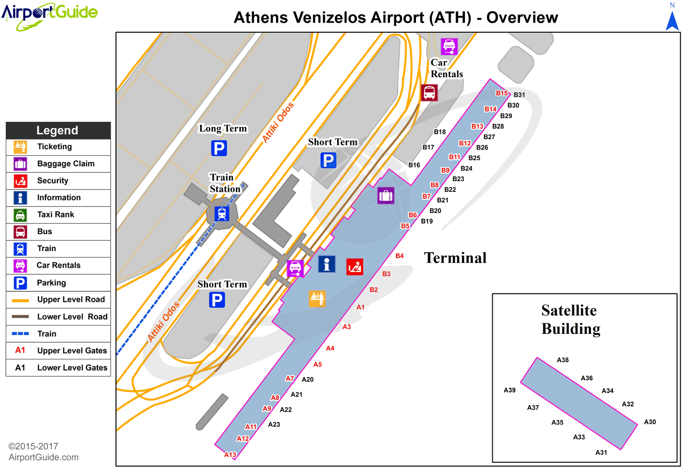
Maps & Diagrams
ATH Sectional
Flight Planning
at skyvector.com
at skyvector.com
