Location
Latitude: |
41-36-11.4550N (41.603182) |
Longitude: |
082-41-06.1950W (-82.685054) |
Elevation: |
598.2 feet MSL (182 m MSL) |
Magnetic Variation: |
7.7 W (as of April 2024 from WMM2020 model) |
Time Zone: |
UTC -5.0 (Standard Time) UTC -4.0 (Daylight Savings Time) |
From City: |
01 N.M. NE of Kelleys Island, Ohio |
Found On: |
Detroit Chart |
FAA Region: |
AGL |
Contacts
Manager: |
Publicly owned: |
| ROBERT QUINN 121 ADDISON ST BOX 469 KELLEYS ISLAND, OH 43438 419-503-0663 |
VILLAGE OF KELLEYS ISLAND 121 ADDISON ST BOX 469 KELLEYS ISLAND, OH 43438 419-746-2535 |
Operations
Airport Status: |
Operational |
Facility Use: |
Public |
Type: |
Airport |
Activation Date: |
05/1949 |
Control tower: |
No |
Attendance (Months/Days/Hours): |
Months/Days/Hours Unattended |
Boundary ARTCC: |
ZOB (Cleveland) |
Responsible ARTCC: |
ZOB (Cleveland) |
Lighting Schedule: |
SS-SR |
Segmented Circle Indicator: |
No |
Traffic Pattern Altitude (MSL): |
1598 feet (487 m) |
NOTAMs Facility: |
CLE |
NOTAM-D Service: |
Yes |
International Airport of Entry: |
No |
Customs Landing Rights: |
No |
Military Landing Rights: |
No |
Civil/Military Joint Use: |
No |
Based Aircraft
| Single Engine: | 2 |
Annual Operations (as of 09/27/2021)
| Total Operations: | 25495 | |
| Air Taxi: | 8695 | 34.1% |
| GA Local: | 7300 | 28.6% |
| GA Itinerant: | 9500 | 37.3% |
Communications
| CTAF: | 122.900 |
Fixed Based Operators (FBOs) & Fuel
(Click on a business for detail)
Please help us keep this information up to date. This is a FREE SERVICE just like everything else on Airport Guide! If you see that a business needs to be added, modified, or deleted please fill out our Update Form.
To add, modify, or delete a business click here.
Please help us keep this information up to date. This is a FREE SERVICE just like everything else on Airport Guide! If you see that a business needs to be added, modified, or deleted please fill out our Update Form.
Area Code: 419 |
| Business Name | Frequency | Phone | Fuel Grade |
|---|
Flight Service Stations
| Primary | Alternate | |
| FSS on Field: | N | |
| FSS Name (ID): | Cleveland(CLE) | |
| Frequency: | ||
| Toll Free Phone: | 1-800-WX-BRIEF |
Instrument Procedures / Charts
Terminal Procedures are only available for airports in several countries with more being added all the time. If you are looking for a specific country's charts, please send an email to support(at)airportguide.com stating the country name. This will be used to prioritize the implementation.
Navigation Aids (Navaids) near 89D
| Dist (NM) | ID | Morse Code | Name | Type | Freq | True Hdg | Mag Hdg |
|---|---|---|---|---|---|---|---|
| 9.7 | PCW | . _ _ . _ . _ . . _ _ | Port Clinton | NDB | 423 | 238 | 246 |
| 10.2 | SKY | . . . _ . _ _ . _ _ | Sandusky | VOR-DME | 109.20 | 172 | 180 |
| 27.7 | DJB | _ . . . _ _ _ _ . . . | Dryer | VOR-DME | 113.60 | 121 | 129 |
| 36.5 | RYS | . _ . _ . _ _ . . . | Grosse Ile | NDB | 419 | 325 | 333 |
| 38.7 | TII | _ . . . . | Tiffin | NDB | 269 | 218 | 225 |
| 39.1 | CLE | _ . _ . . _ . . . | Cleveland | VOT | 110.40 | 106 | 114 |
| 39.3 | YQG | _ . _ _ _ _ . _ _ _ . | Windsor | VOR-DME | 113.80 | 350 | 358 |
| 40.5 | FZI | . . _ . _ _ . . . . | Fostoria | NDB | 379 | 232 | 239 |
| 41.7 | ZQG | Laurel | NDB | 398 | 337 | 345 | |
| 43.0 | AAU | . _ . _ . . _ | Ashland | NDB | 329 | 152 | 160 |
| 43.4 | QG | Windsor | NDB | 353 | 349 | 357 | |
| 43.6 | JZJ | . _ _ _ _ _ . . . _ _ _ | Alaina | NDB | 223 | 328 | 336 |
| 43.7 | CRL | _ . _ . . _ . . _ . . | Carleton | VOR-DME | 115.70 | 307 | 314 |
| 43.8 | VWV | . . . _ . _ _ . . . _ | Waterville | VOR-DME | 113.10 | 258 | 265 |
| 44.3 | MFD | _ _ . . _ . _ . . | Mansfield | VORTAC | 108.80 | 174 | 182 |
| 46.8 | VQ | . . . _ _ _ . _ | Cargl | NDB | 230 | 345 | 353 |
| 47.6 | DXO | _ . . _ . . _ _ _ _ | Detroit | VOR-DME | 113.40 | 320 | 328 |
| 48.2 | DTW | _ . . _ . _ _ | Detroit Met Wayne | VOT | 109.80 | 321 | 329 |
| 50.0 | TOL | _ _ _ _ . _ . . | Toledo | TACAN | 112.50 | 269 | 276 |
| 50.3 | DET | _ . . . _ | Detroit City | VOT | 111.60 | 343 | 351 |
Nearby Airports with Fuel
Notices to Airmen (NOTAMS)
Remarks
| A110-1 | DEER ON & INVOF ARPT. |
| A110-2 | FOR CD CTC CLEVELAND APCH AT 216-352-2323. |
| A13 | UNMON ARPT TRML 419-746-2228. |
| A57-09 | APCH SLP 7:1 TO DTHR DUE TO +54 FT TREE, 594 FT DIST, 139 FT R. |
| A58-09 | 10 FT ROAD, 12 FT DIST, 125 FT L/R. |
| A58-27 | +10 FT ROAD, 0-92 FT DIST, 0-125 FT L; +4 FT PROPANE TANK, 104-120 FT DIST, 87-92 FT L; +18 FT HOUSE, 102-200 FT DIST, 94-125 FT L; +12 FT TREES, 106-136 FT DIST, 80 FT L. |
| E111 | VFR OPNS ONLY. |
Runways
Runway Summary
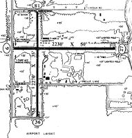
| Runways: | 09/27 |
| Longest Runway: | 09/27 is 2202 ft (671 m) long |
| Runways with an Instrument Approach: |
89D Airport Runway Details
| Runway 09/27 | 2202 ft x 50 ft (671 m x 15 m) | |
| Runway Length Source: | FAA OE/AAA as of 01/20/2016 | |
| Surface: | Asphalt - Good condition - No special surface treatment | |
| Runway Edge Lights: | Low Intensity | |
Runway 09 |
Runway 27 |
|
Elevation: |
598.2 | 578.9 |
Latitude: |
41-36-11.9000N | 41-36-11.0100N |
Longitude: |
082-41-20.6700W | 082-40-51.7200W |
|
Runway True Alignment: |
092 | 272 |
Glide Path Angle: |
0.0 degrees | 0.0 degrees |
Traffic Pattern: |
Left | Left |
Runway Markings Type: |
Basic | Basic |
Runway Markings Condition: |
Fair | Fair |
Object at End: |
TREES | FENCE |
Object Height: |
54 | 3 |
Distance from End: |
394 | 201 |
Object Centerline Offset: |
139 ft. right of centerline | 100 ft. left of centerline |
REIL: |
No | No |
Touchdown Lights: |
No | No |
Centerline Lights: |
No | No |
Threshold Elevation: |
596.9 | |
Displaced Threshold: |
200 | |
Threshold Latitude: |
41-36-11.8200N | |
Threshold Longitude: |
082-41-18.0500W |
Services
Airframe Repair: |
Major |
Powerplant Repair: |
Major |
Bottled Oxygen: |
None |
Bulk Oxygen: |
None |
Fuel Available: |
100LL, Jet A+ |
Landing Fees: |
No |
Parking: |
Hangars and tiedowns available |
Maps & Diagrams
89D Sectional
Flight Planning
at skyvector.com
at skyvector.com