Location
Latitude: |
32-24-02.3690N (32.400658) |
Longitude: |
083-16-42.2630W (-83.278406) |
Elevation: |
377.4 feet MSL (115 m MSL) |
Magnetic Variation: |
6.1 W (as of April 2024 from WMM2020 model) |
Time Zone: |
UTC -5.0 (Standard Time) UTC -4.0 (Daylight Savings Time) |
From City: |
04 N.M. E of Cochran, Georgia |
Found On: |
Atlanta Chart |
FAA Region: |
ASO |
Contacts
Manager: |
Publicly owned: |
| JIM WASHBURN 829 GA HWY 126 COCHRAN, GA 31014 478-291-6582 |
CITY OF COCHRAN CITY HALL, PO BOX 8 COCHRAN, GA 31014 478-934-6346 |
Operations
Airport Status: |
Operational |
Facility Use: |
Public |
Type: |
Airport |
Activation Date: |
05/1941 |
Control tower: |
No |
Attendance (Months/Days/Hours): |
Months/Days/Hours ALL/MON-SAT/0800-1200 |
Boundary ARTCC: |
ZTL (Atlanta) |
Responsible ARTCC: |
ZTL (Atlanta) |
Lighting Schedule: |
SEE RMK |
Segmented Circle Indicator: |
Yes |
Traffic Pattern Altitude (MSL): |
1377 feet (420 m) |
NOTAMs Facility: |
MCN |
NOTAM-D Service: |
Yes |
International Airport of Entry: |
No |
Customs Landing Rights: |
No |
Military Landing Rights: |
Yes |
Civil/Military Joint Use: |
No |
Based Aircraft
| Single Engine: | 17 |
| Multi Engine: | 4 |
Annual Operations (as of 12/31/2022)
| Total Operations: | 14000 | |
| GA Local: | 11500 | 82.1% |
| GA Itinerant: | 2100 | 15.0% |
| Military Aircraft: | 400 | 2.9% |
Communications
| CTAF: | 122.800 |
| Unicom: | 122.800 |
| Approach: | ATLANTA 124.2 124.2 124.2 ATLANTA ARTCC |
| Departure: | ATLANTA 124.2 124.2 124.2 ATLANTA ARTCC |
| AWOS-3PT: | 120.975 (478-271-5897) |
- ATLANTA LARGE TRACON PROVIDES APCH/DEP SVC 0615-2300 ON FREQ 124.2/279.6; ATLANTA ARTCC PROVIDES APCH/DEP SVC 2300-0615 ON FREQS 134.5/360.75 (MACON RCAG).
Fixed Based Operators (FBOs) & Fuel
(Click on a business for detail)
Please help us keep this information up to date. This is a FREE SERVICE just like everything else on Airport Guide! If you see that a business needs to be added, modified, or deleted please fill out our Update Form.
To add, modify, or delete a business click here.
Please help us keep this information up to date. This is a FREE SERVICE just like everything else on Airport Guide! If you see that a business needs to be added, modified, or deleted please fill out our Update Form.
Area Code: 912 |
| Business Name | Frequency | Phone | Fuel Grade |
|---|---|---|---|
| Cochran Air Service, Inc.
Update FBO info |
Unicom 122.8 | 934-2137 | 100LL |
Flight Service Stations
| Primary | Alternate | |
| FSS on Field: | N | |
| FSS Name (ID): | Macon(MCN) | |
| Frequency: | ||
| Toll Free Phone: | 1-800-WX-BRIEF |
Instrument Procedures / Charts
FAA Terminal Procedures valid from 0901Z 03/21/24 to 0901Z 04/18/24.
There are various types of charts available for an airport. They are listed in the Page Type column. Here is a legend for those types:
APD - Airport Diagram
DP - Departure Procedure Charts
HOT - Hot Spots
IAP - Instrument Approach Procedure Charts
MIN - Minimums
STAR - Standard Terminal Arrival Charts
| Page Type | Page Name | Volume | Action Since Last Cycle |
|---|---|---|---|
| IAP | RNAV (GPS) RWY 11 | SE-4 | |
| IAP | RNAV (GPS) RWY 29 | SE-4 | |
| MIN | ALTERNATE MINIMUMS | SE-4 | |
| MIN | TAKEOFF MINIMUMS | SE-4 |
Terminal Procedures are only available for airports in several countries with more being added all the time. If you are looking for a specific country's charts, please send an email to support(at)airportguide.com stating the country name. This will be used to prioritize the implementation.
Navigation Aids (Navaids) near 48A
| Dist (NM) | ID | Morse Code | Name | Type | Freq | True Hdg | Mag Hdg |
|---|---|---|---|---|---|---|---|
| 14.4 | DB | _ . . _ . . . | Creke | NDB | 251 | 69 | 75 |
| 15.8 | VNA | . . . _ _ . . _ | Vienna | VORTAC | 116.50 | 224 | 230 |
| 17.3 | EZM | . _ _ . . _ _ | Eastman | NDB | 366 | 158 | 164 |
| 21.4 | WRB | . _ _ . _ . _ . . . | Robins | TACAN | 135.30 | 312 | 318 |
| 24.7 | DBN | _ . . _ . . . _ . | Dublin | VORTAC | 113.10 | 66 | 72 |
| 24.9 | BEP | _ . . . . . _ _ . | Bay Creek | NDB | 350 | 277 | 283 |
| 25.5 | MCN | _ _ _ . _ . _ . | Macon | DME | 114.2 | 313 | 319 |
| 27.2 | MQW | _ _ _ _ . _ . _ _ | Mc Rae | NDB | 280 | 132 | 138 |
| 37.0 | IZS | . . _ _ . . . . . | Montezuma | NDB | 426 | 267 | 273 |
| 38.2 | OHY | _ _ _ . . . . _ . _ _ | Coney | NDB | 400 | 230 | 236 |
| 40.7 | HIT | . . . . . . _ | Kaolin | NDB | 360 | 24 | 30 |
| 44.2 | LKG | . _ . . _ . _ _ _ . | Lindbergh | NDB | 242 | 252 | 258 |
| 44.7 | EEX | . . _ . . _ | Emanuel County | NDB | 309 | 68 | 74 |
| 44.8 | AZE | . _ _ _ . . . | Hazlehurst | NDB | 414 | 134 | 140 |
| 45.5 | UMB | . . _ _ _ _ . . . | Culvr | NDB | 380 | 7 | 13 |
| 47.3 | SUR | . . . . . _ . _ . | Fitzgerald | NDB | 362 | 180 | 186 |
| 50.9 | UQN | . . _ _ _ . _ _ . | Onyun | NDB | 372 | 101 | 107 |
| 55.5 | OP | _ _ _ . _ _ . | Yates | NDB | 339 | 304 | 310 |
| 59.3 | IFM | . . . . _ . _ _ | Tift Myers | VOR | 112.50 | 190 | 196 |
| 60.7 | RVJ | . _ . . . . _ . _ _ _ | Prison | NDB | 424 | 109 | 115 |
Nearby Airports with Fuel
Notices to Airmen (NOTAMS)
Remarks
| A110-1 | NON STD TURNAROUNDS, INADEQUATE SEPARATION RUNWAY 05/23. |
| A110-2 | FOR CD CTC ATLANTA APCH AT 678-364-6132, WHEN APCH CLSD CTC ATLANTA ARTCC AT 770-210-7692. |
| A16 | ALT PHONE 478-230-7843 |
| A30-05/23 | RWY 5/23 IS DAYLIGHT USE ONLY. |
| A33-05/23 | RWY 05/23 PAVEMENT IN POOR COND. |
| A70-FUEL-10 | 0LL 24HR FUEL SELF SERV W/MAJOR CREDIT CARD. |
| A81-APT | MIRL RWY 11/29 PRESET LOW DAWN-0800, DUSK-2100; TO ACTVT OR INCRS INTST - CTAF. |
Runways
Runway Summary
| Runways: | 05/23 11/29 |
| Longest Runway: | 11/29 is 4400 ft (1341 m) long |
| Runways with an Instrument Approach: |
48A Airport Runway Details
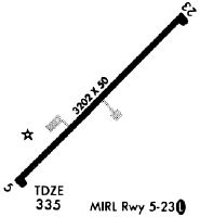
| Runway 05/23 | 3202 ft x 50 ft (976 m x 15 m) | |
| Runway Length Source: | 3RD PARTY SURVEY as of 12/06/2021 | |
| Surface: | Asphalt - Poor condition - No special surface treatment | |
Runway Weight Bearing Capacity (in thousands of pounds) |
||
| Single Wheel Landing Gear: | 25.0 | |
Runway 05 |
Runway 23 |
|
Elevation: |
324.2 | 332.5 |
Latitude: |
32-23-46.6984N | 32-24-08.6521N |
Longitude: |
083-16-46.7813W | 083-16-19.8595W |
|
Runway True Alignment: |
046 | 226 |
Glide Path Angle: |
0.0 degrees | 0.0 degrees |
Traffic Pattern: |
Left | Left |
Runway Markings Type: |
Nonprecision Instrument | Nonprecision Instrument |
Runway Markings Condition: |
Good | Good |
Object at End: |
TREES | TREES |
Object Height: |
44 | 40 |
Distance from End: |
720 | 1143 |
Object Centerline Offset: |
88 ft. right of centerline | 27 ft. left of centerline |
Threshold Elevation: |
333.9 | |
Displaced Threshold: |
140 | |
Threshold Latitude: |
32-24-07.6951N | |
Threshold Longitude: |
083-16-21.0426W | |
Declared Distances |
||
Take Off Run Avbl. (TORA): |
3202 | |
Take Off Distance Avbl. (TODA): |
3202 | |
Actual Stop Dist. Avbl. (ASDA): |
3202 | |
Landing Dist. Avbl. (LDA): |
3062 | |
| Runway 11/29 | 4400 ft x 75 ft (1341 m x 23 m) | |
| Runway Length Source: | 3RD PARTY SURVEY as of 12/06/2021 | |
| Surface: | Asphalt - Poor condition - No special surface treatment | |
| Runway Edge Lights: | Medium Intensity | |
Runway 11 |
Runway 29 |
|
Elevation: |
377.4 | 333.6 |
Latitude: |
32-24-11.0659N | 32-24-00.5011N |
Longitude: |
083-17-13.6625W | 083-16-23.8774W |
|
Runway True Alignment: |
104 | 284 |
Glide Path Angle: |
3.2 degrees | 3.0 degrees |
Runway Markings Type: |
Nonprecision Instrument | Nonprecision Instrument |
Runway Markings Condition: |
Good | Good |
Object at End: |
TREES | TREES |
Object Height: |
67 | 68 |
Distance from End: |
1359 | 2363 |
Object Centerline Offset: |
88 ft. right of centerline | 27 ft. left of centerline |
Visual Glide Slope Indicators: |
2-Light PAPI On Left Side Of Runway | 2-Light PAPI On Left Side Of Runway |
Threshold Crossing Height: |
45 | 40 |
Services
Airframe Repair: |
Minor |
Powerplant Repair: |
Minor |
Bottled Oxygen: |
None |
Bulk Oxygen: |
None |
Fuel Available: |
100LL |
Landing Fees: |
No |
Parking: |
Tiedowns available |
Maps & Diagrams
48A Sectional
Flight Planning
at skyvector.com
at skyvector.com