Location
Latitude: |
45-17-36.6000N (45.2935) |
Longitude: |
114-56-43.1000W (-114.945306) |
Elevation: |
7030.0 feet MSL (2143 m MSL) |
Magnetic Variation: |
12.8 E (as of April 2024 from WMM2020 model) |
Time Zone: |
UTC -7.0 (Standard Time) UTC -6.0 (Daylight Savings Time) |
From City: |
00 N.M. NW of Cold Meadows Guard Station, Idaho |
Found On: |
Great Falls Chart |
FAA Region: |
ANM |
Contacts
Manager: |
Publicly owned: |
| KRASSEL DISTRICT RANGER 500 NORTH MISSION ST. MC CALL, ID 83638 208-634-0600 |
U S FOREST SERVICE 324 25TH ST OGDEN, UT 84401 801-625-5511 |
Operations
Airport Status: |
Operational |
Facility Use: |
Public |
Type: |
Airport |
Activation Date: |
08/1947 |
Control tower: |
No |
Attendance (Months/Days/Hours): |
Months/Days/Hours Unattended |
Boundary ARTCC: |
ZLC (Salt Lake City) |
Responsible ARTCC: |
ZLC (Salt Lake City) |
Segmented Circle Indicator: |
Yes |
Traffic Pattern Altitude (MSL): |
8030 feet (2448 m) |
NOTAMs Facility: |
BOI |
NOTAM-D Service: |
Yes |
Military Landing Rights: |
No |
Civil/Military Joint Use: |
No |
Based Aircraft
Annual Operations (as of 08/30/2021)
| Total Operations: | 2000 | |
| Air Taxi: | 1000 | 50.0% |
| GA Itinerant: | 1000 | 50.0% |
Communications
| CTAF: | 122.900 |
Fixed Based Operators (FBOs) & Fuel
(Click on a business for detail)
Please help us keep this information up to date. This is a FREE SERVICE just like everything else on Airport Guide! If you see that a business needs to be added, modified, or deleted please fill out our Update Form.
To add, modify, or delete a business click here.
Please help us keep this information up to date. This is a FREE SERVICE just like everything else on Airport Guide! If you see that a business needs to be added, modified, or deleted please fill out our Update Form.
Area Code: 208 |
| Business Name | Frequency | Phone | Fuel Grade |
|---|
Flight Service Stations
| Primary | Alternate | |
| FSS on Field: | N | |
| FSS Name (ID): | Boise(BOI) | |
| Frequency: | ||
| Toll Free Phone: | 1-800-WX-BRIEF |
Instrument Procedures / Charts
Terminal Procedures are only available for airports in several countries with more being added all the time. If you are looking for a specific country's charts, please send an email to support(at)airportguide.com stating the country name. This will be used to prioritize the implementation.
Navigation Aids (Navaids) near U81
| Dist (NM) | ID | Morse Code | Name | Type | Freq | True Hdg | Mag Hdg |
|---|---|---|---|---|---|---|---|
| 39.9 | LKT | . _ . . _ . _ _ | Salmon | VOR-DME | 113.50 | 113 | 100 |
| 62.1 | DNJ | _ . . _ . . _ _ _ | Donnelly | VOR-DME | 116.20 | 239 | 226 |
| 78.8 | IDQ | . . _ . . _ _ . _ | Cottonwood | DME | 115.65 | 306 | 293 |
Nearby Airports with Fuel
| Dist (NM) | Name (Airport IDs) | True Hdg | Mag Hdg | Fuel Grade |
|---|---|---|---|---|
| 45.8 | West Fork Lodge Airport (4U7) |
41 | 28 | Mogas |
| 46.1 | Lemhi County Airport (SMN KSMN SMN) |
102 | 90 | 100, Jet A |
| 54.7 | Mc Call Municipal Airport (MYL KMYL MYL) |
244 | 231 | 100LL, Jet A, Jet A-1+ |
| 55.6 | Challis Airport (CHL KLLJ LLJ) |
145 | 133 | 100, Jet A |
| 62.9 | Idaho County Airport (KGIC GIC) |
308 | 295 | 100LL, Jet A |
| 65.1 | Stanley Airport (2U7) |
179 | 166 | 100LL |
| 66.2 | Cascade Airport (U70) |
223 | 210 | 100LL, Jet A |
| 67.3 | Ravalli County Airport (HRF) |
30 | 17 | 100LL, Jet A, Jet A+ |
| 71.3 | Kamiah Municipal Airport (S73) |
321 | 308 | 100LL |
| 71.5 | Council Municipal Airport (U82) |
243 | 230 | 100LL |
| 73.3 | Cottonwood Municipal Airport (S84) |
308 | 295 | 100LL |
| 82.8 | Stevensville Airport (32S) |
26 | 13 | 100LL |
| 86.0 | Craigmont Municipal Airport (S89) |
312 | 299 | 100LL |
| 90.9 | Orofino Municipal Airport (S68) |
322 | 309 | 100LL |
| 98.1 | Enterprise Municipal Airport (8S4) |
275 | 262 | 100LL |
Notices to Airmen (NOTAMS)
Remarks
| A110-1 | NO WINTER MAINTENANCE. |
| A110-10 | FOR CD CTC SALT LAKE ARTCC AT 801-320-2568. |
| A110-2 | VERY HIGH DENSITY ALT FACTOR DURING SUMMER MONTHS. |
| A110-3 | RODENT ACTIVITY ON AND INVOF ARPT. |
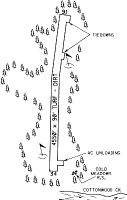
| A110-4 | BE ADVISED USFS RECOMMENDS LEFT TURNOUT DOWN COTTON WOOD CREEK AFTER DEPARTING RY 16. |
| A110-6 | NO TELEPHONE AVBL AT ARPT. |
| A110-7 | RY MAY BE SOFT IN EARLY SPRING. |
| A110-8 | RUBBER WATER BAR STRIPS ON RY. |
| A110-9 | BIG GAME ANIMALS AND LIVESTOCK ON & INVOF RY. |
| A30-16/34 | WHEN WIND CONDS PERMIT LND RY 34; DEP RY 16. |
| A31-16/34 | RWY 16/34 FIRST 500 FT OF RWY 34 VERY ROUGH. |
| A33-16/34 | ONLY 20 FT - CTR PTN OF RWY LEN IS DIRT & USED FOR TKOF & LDG. |
| A42-16 | UNPAINTED ROCK BOUNDARY MARKERS. |
| A52-16 | RWY 16 +30 FT TREES AT 10 FT ON CNTRLN; +25 FT TREES AT 5 FT 50 FT L. |
| A52-34 | 125 FT TIMBERED RIDGE AT 350 FT & 200 FT L. |
| E111 | ESTABD PRIOR TO 31 DEC 1958. |
Runways
Runway Summary
| Runways: | 16/34 |
| Longest Runway: | 16/34 is 4550 ft (1387 m) long |
| Runways with an Instrument Approach: |
U81 Airport Runway Details
| Runway 16/34 | 4550 ft x 90 ft (1387 m x 27 m) | |
| Surface: | Turf/Dirt - Fair condition - No special surface treatment | |
Runway 16 |
Runway 34 |
|
Elevation: |
6966.0 | 6941.0 |
Latitude: |
45-17-59.0600N | 45-17-14.1900N |
Longitude: |
114-56-44.9000W | 114-56-41.2400W |
Glide Path Angle: |
0.0 degrees | 0.0 degrees |
Traffic Pattern: |
Left | Left |
Object at End: |
TREES | HILL |
Object Height: |
30 | 130 |
Distance from End: |
0 | 450 |
Object Centerline Offset: |
40 ft. right of centerline | 0 ft. left and right of centerline |
Services
Airframe Repair: |
Minor |
Powerplant Repair: |
Minor |
Bottled Oxygen: |
None |
Bulk Oxygen: |
None |
Fuel Available: |
100LL |
Landing Fees: |
No |
Parking: |
Tiedowns available |
Maps & Diagrams
U81 Sectional
Flight Planning
at skyvector.com
at skyvector.com