Location
Latitude: |
43-25-57.3000N (43.432583) |
Longitude: |
113-03-19.6000W (-113.055444) |
Elevation: |
5073.0 feet MSL (1546 m MSL) |
Magnetic Variation: |
11.8 E (as of April 2024 from WMM2020 model) |
Time Zone: |
UTC -7.0 (Standard Time) UTC -6.0 (Daylight Savings Time) |
From City: |
10 N.M. W of Atomic City, Idaho |
Found On: |
Salt Lake City Chart |
FAA Region: |
ANM |
Contacts
Manager: |
Publicly owned: |
| ID DIV OF AERONAUTICS P O BOX 7129 BOISE, ID 83707-1129 208-334-8775 |
STATE OF ID,ITD,DIV AERO P O BOX 7129 BOISE, ID 83707-1129 208-334-8775 |
Operations
Airport Status: |
Operational |
Facility Use: |
Public |
Type: |
Airport |
Activation Date: |
06/1951 |
Control tower: |
No |
Attendance (Months/Days/Hours): |
Months/Days/Hours Unattended |
Boundary ARTCC: |
ZLC (Salt Lake City) |
Responsible ARTCC: |
ZLC (Salt Lake City) |
Segmented Circle Indicator: |
Yes |
Traffic Pattern Altitude (MSL): |
6073 feet (1851 m) |
NOTAMs Facility: |
BOI |
NOTAM-D Service: |
Yes |
International Airport of Entry: |
No |
Customs Landing Rights: |
No |
Based Aircraft
Annual Operations (as of 06/30/2022)
| Total Operations: | 150 | |
| GA Itinerant: | 150 | 100.0% |
Communications
| CTAF: | 122.900 |
Fixed Based Operators (FBOs) & Fuel
(Click on a business for detail)
Please help us keep this information up to date. This is a FREE SERVICE just like everything else on Airport Guide! If you see that a business needs to be added, modified, or deleted please fill out our Update Form.
To add, modify, or delete a business click here.
Please help us keep this information up to date. This is a FREE SERVICE just like everything else on Airport Guide! If you see that a business needs to be added, modified, or deleted please fill out our Update Form.
Area Code: 208 |
| Business Name | Frequency | Phone | Fuel Grade |
|---|
Flight Service Stations
| Primary | Alternate | |
| FSS on Field: | N | |
| FSS Name (ID): | Boise(BOI) | |
| Frequency: | ||
| Toll Free Phone: | 1-800-WX-BRIEF |
Instrument Procedures / Charts
Terminal Procedures are only available for airports in several countries with more being added all the time. If you are looking for a specific country's charts, please send an email to support(at)airportguide.com stating the country name. This will be used to prioritize the implementation.
Navigation Aids (Navaids) near U46
| Dist (NM) | ID | Morse Code | Name | Type | Freq | True Hdg | Mag Hdg |
|---|---|---|---|---|---|---|---|
| 36.7 | PI | . _ _ . . . | Tyhee | NDB | 383 | 139 | 127 |
| 38.1 | PIH | . _ _ . . . . . . . | Pocatello | VOR-DME | 112.60 | 152 | 140 |
| 38.9 | SWU | . . . . _ _ . . _ | Sweden | NDB | 350 | 89 | 77 |
| 43.5 | IDA | . . _ . . . _ | Idaho Falls | VOR-DME | 113.85 | 82 | 70 |
| 47.8 | ID | . . _ . . | Uconn | NDB | 324 | 77 | 65 |
| 52.2 | HLE | . . . . . _ . . . | Hailey | NDB-DME | 220 | 263 | 251 |
| 53.8 | DBS | _ . . _ . . . . . . | Dubois | VORTAC | 116.90 | 42 | 30 |
| 62.3 | BYI | _ . . . _ . _ _ . . | Burley | VOR-DME | 114.10 | 215 | 203 |
| 77.3 | HDG | . . . . _ . . _ _ . | Steelhead | NDB | 211 | 246 | 234 |
| 78.6 | MLD | _ _ . _ . . _ . . | Malad City | VOR-DME | 117.40 | 160 | 148 |
| 80.8 | TW | _ . _ _ | Strik | NDB | 389 | 225 | 213 |
| 85.0 | TWF | _ . _ _ . . _ . | Twin Falls | VORTAC | 113.10 | 228 | 216 |
Nearby Airports with Fuel
Notices to Airmen (NOTAMS)
Remarks
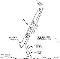
| A110-1 | NO WINTER MAINTENANCE. |
| A110-2 | LIVESTOCK ON & INVOF ARPT. |
| A110-3 | RY 01/19 SFC MAY BE POOR DUE TO DAMAGE BY LIVESTOCK; GROUND VEHICLES AND RODENTS. |
| A110-4 | RY 01/19 +1.5 FT BERM & -1 FT DITCH ADJACENT TO ENTIRE PERIMETER OF RY. |
| A110-5 | FOR CD CTC SALT LAKE ARTCC AT 801-320-2568. |
| A42-01 | 01/19 EDGES & THLDS MKD WITH WHITE ROCK BOUNDARY MKRS (BMS). |
| A52-19 | 14' RD AT 150' ON CNTRLN. |
| E111 | EXISTED PRIOR TO 15 MAY 1959. |
Runways
Runway Summary
| Runways: | 01/19 |
| Longest Runway: | 01/19 is 2600 ft (792 m) long |
| Runways with an Instrument Approach: |
U46 Airport Runway Details
| Runway 01/19 | 2600 ft x 110 ft (792 m x 34 m) | |
| Surface: | Dirt - Fair condition - No special surface treatment | |
Runway 01 |
Runway 19 |
|
Latitude: |
43-25-46.1600N | 43-26-08.5100N |
Longitude: |
113-03-28.2400W | 113-03-10.8700W |
Glide Path Angle: |
0.0 degrees | 0.0 degrees |
Traffic Pattern: |
Left | Left |
Object at End: |
ROAD | |
Object Height: |
15 | |
Distance from End: |
0 | |
Object Centerline Offset: |
100 ft. left of centerline |
Services
Airframe Repair: |
Minor |
Powerplant Repair: |
Minor |
Bottled Oxygen: |
None |
Bulk Oxygen: |
None |
Fuel Available: |
100LL |
Landing Fees: |
No |
Parking: |
Tiedowns available |
Maps & Diagrams
U46 Sectional
Flight Planning
at skyvector.com
at skyvector.com