
Location
Latitude: |
32-07-01.4455N (32.117068) |
Longitude: |
110-56-29.2661W (-110.941463) |
Elevation: |
2643.0 feet MSL (806 m MSL) |
Magnetic Variation: |
9.2 E (as of April 2024 from WMM2020 model) |
Time Zone: |
UTC -7.0 (Standard Time) UTC -7.0 (Daylight Savings Time) |
From City: |
06 N.M. S of Tucson, Arizona |
Found On: |
Phoenix Chart |
FAA Region: |
AWP |
Contacts
Manager: |
Publicly owned: |
| DANETTE BEWLEY TUCSON APT AUTH 7250 S TUCSON BLVD, SUITE 300 TUCSON, AZ 85756 520-573-4845 |
TUCSON AIRPORT AUTHORITY 7250 SOUTH TUCSON BLVD, SUITE 300 TUCSON, AZ 85756 520-573-8100 |
Operations
Airport Status: |
Operational |
Facility Use: |
Public |
Type: |
Airport |
Activation Date: |
11/1941 |
Control tower: |
Yes |
Attendance (Months/Days/Hours): |
Months/Days/Hours ALL/ALL/ALL |
Boundary ARTCC: |
ZAB (Albuquerque) |
Responsible ARTCC: |
ZAB (Albuquerque) |
Lighting Schedule: |
SS-SR |
Segmented Circle Indicator: |
No |
Traffic Pattern Altitude (MSL): |
3643 feet (1110 m) |
NOTAMs Facility: |
TUS |
NOTAM-D Service: |
Yes |
International Airport of Entry: |
Yes |
Customs Landing Rights: |
No |
Military Landing Rights: |
Yes |
Civil/Military Joint Use: |
No |
Aircraft Rescue and Firefighting: |
Class I ARFF Index: C Air Carrier Service: Scheduled Certification Date: 05/1973 |
Based Aircraft
| Single Engine: | 160 |
| Multi Engine: | 14 |
| Jet Engine: | 161 |
| GA Helicopters: | 8 |
| Military Aircraft: | 73 |
Annual Operations (as of 12/31/2022)
| Total Operations: | 142389 | |
| Commercial: | 32436 | 22.8% |
| Air Taxi: | 17932 | 12.6% |
| GA Local: | 24044 | 16.9% |
| GA Itinerant: | 40372 | 28.4% |
| Military Aircraft: | 27605 | 19.4% |
Communications
| Unicom: | 122.950 |
| Tower: | TUCSON 118.3 257.8 119.0 Hrs: 24 |
| Clearance Del.: | 126.65 326.2 |
| Ground: | 120.025 348.6 |
| Approach: | TUCSON |
| Departure: | TUCSON |
| ATIS: | 123.8 279.65 Hrs: 24 |
| ASOS: | (520-295-4089) |
| EMERG: | 121.5 |
| ANG COMD POST: | 138.525 |
| EMERG: | 243.0 |
Fixed Based Operators (FBOs) & Fuel
(Click on a business for detail)
Please help us keep this information up to date. This is a FREE SERVICE just like everything else on Airport Guide! If you see that a business needs to be added, modified, or deleted please fill out our Update Form.
To add, modify, or delete a business click here.
Please help us keep this information up to date. This is a FREE SERVICE just like everything else on Airport Guide! If you see that a business needs to be added, modified, or deleted please fill out our Update Form.
Area Code: 520 |
| Business Name | Frequency | Phone | Fuel Grade |
|---|---|---|---|
| Bombardier Aerospace
Update FBO info |
Unicom 123.52 | 746-5100 | |
| Custom Aviation Maintenance
Update FBO info |
889-3259 | ||
| Double Eagle Aviation
Update FBO info |
294-8214, 800-505-0148 | 100LL | |
| FlightSafety International
Website Update FBO info |
918-7100 | ||
| Hamilton Aviation
Update FBO info |
294-3481 | ||
| Leading Edge
Update FBO info |
741-1921 | 100LL | |
| Premier Aviation
Update FBO info |
Unicom 122.95 | 889-6327, 800-274-8451 | 100LL, Jet A |
| Ratliff Aviation
Update FBO info |
Unicom 122.95 | 746-1411 | Jet A |
| Sun West Aviation
Update FBO info |
889-8191 | ||
| Tucson Airport Authority
Update FBO info |
Unicom 122.95 | 573-8190, -8191 | 100LL, Jet A |
| Tucson Jet Center
Update FBO info |
Unicom 122.95 (0800-1700) | 889-0593, 800-889-0593 | 100LL, Jet A |
Flight Service Stations
| Primary | Alternate | |
| FSS on Field: | N | |
| FSS Name (ID): | Prescott(PRC) | |
| Frequency: | ||
| Toll Free Phone: | 1-800-WX-BRIEF |
Instrument Procedures / Charts
FAA Terminal Procedures valid from 0901Z 03/21/24 to 0901Z 04/18/24.
There are various types of charts available for an airport. They are listed in the Page Type column. Here is a legend for those types:
APD - Airport Diagram
DP - Departure Procedure Charts
HOT - Hot Spots
IAP - Instrument Approach Procedure Charts
MIN - Minimums
STAR - Standard Terminal Arrival Charts
| Page Type | Page Name | Volume | Action Since Last Cycle |
|---|---|---|---|
| APD | AIRPORT DIAGRAM | SW-4 | |
| DP | BURRO FIVE (RNAV) | SW-4 | Changed |
| DP | TUCSON NINE | SW-4 | Changed |
| DP | TUCSON NINE[DELIMITER] CONT.1 | SW-4 | |
| DP | WLDKT FOUR (RNAV) | SW-4 | Changed |
| HOT | HOT SPOT | SW-4 | |
| IAP | ILS OR LOC RWY 12 | SW-4 | |
| IAP | RNAV (GPS) RWY 04 | SW-4 | |
| IAP | RNAV (GPS) RWY 22 | SW-4 | |
| IAP | RNAV (GPS) Z RWY 12 | SW-4 | |
| IAP | RNAV (GPS) Z RWY 30 | SW-4 | |
| IAP | RNAV (RNP) Y RWY 11L | SW-4 | |
| IAP | RNAV (RNP) Y RWY 12 | SW-4 | |
| IAP | RNAV (RNP) Y RWY 29R | SW-4 | |
| IAP | RNAV (RNP) Y RWY 30 | SW-4 | |
| IAP | VOR OR TACAN RWY 12 | SW-4 | |
| IAP | VOR OR TACAN RWY 30 | SW-4 | |
| MIN | ALTERNATE MINIMUMS | SW-4 | |
| MIN | DIVERSE VECTOR AREA | SW-4 | |
| MIN | TAKEOFF MINIMUMS | SW-4 | |
| STAR | DINGO SIX | SW-4 | Changed |
| STAR | ZONNA TWO (RNAV) | SW-4 |
Terminal Procedures are only available for airports in several countries with more being added all the time. If you are looking for a specific country's charts, please send an email to support(at)airportguide.com stating the country name. This will be used to prioritize the implementation.
Navigation Aids (Navaids) near TUS
| Dist (NM) | ID | Morse Code | Name | Type | Freq | True Hdg | Mag Hdg |
|---|---|---|---|---|---|---|---|
| 1.9 | TUS | _ . . _ . . . | Tucson | VORTAC | 116.00 | 134 | 125 |
| 4.0 | DMA | _ . . _ _ . _ | Davis Monthan | TACAN | 117.60 | 50 | 41 |
| 11.3 | RYN | . _ . _ . _ _ _ . | Ryan | NDB | 338 | 276 | 267 |
| 21.4 | RBJ | . _ . _ . . . . _ _ _ | Robles | NDB | 220 | 263 | 254 |
| 22.5 | AVQ | . _ . . . _ _ _ . _ | Marana | NDB | 245 | 321 | 312 |
| 42.0 | ENZ | . _ . _ _ . . | Nogales | NDB | 394 | 173 | 164 |
| 42.4 | OLS | _ _ _ . _ . . . . . | Nogales | VOR-DME | 114.65 | 173 | 164 |
| 43.5 | FHU | . . _ . . . . . . . _ | Libby | VOR-DME | 113.60 | 136 | 127 |
| 44.1 | DAO | _ . . . _ _ _ _ | Dragoo | NDB | 410 | 136 | 127 |
| 44.3 | ARH | . _ . _ . . . . . | Fort Huachuca | TACAN | 111.60 | 135 | 126 |
| 67.3 | TFD | _ . . _ . _ . . | Stanfield | VORTAC | 114.80 | 313 | 304 |
| 78.5 | DUG | _ . . . . _ _ _ . | Douglas | VORTAC | 108.80 | 119 | 110 |
| 79.7 | IWA | . . . _ _ . _ | Willie | VORTAC | 113.30 | 333 | 324 |
| 81.7 | CHD | _ . _ . . . . . _ . . | Chandler | NDB | 407 | 327 | 318 |
| 85.7 | SSO | . . . . . . _ _ _ | San Simon | VORTAC | 115.40 | 83 | 74 |
| 90.0 | FFZ | . . _ . . . _ . _ _ . . | Falcon Field | NDB | 281 | 333 | 324 |
| 94.5 | PXR | . _ _ . _ . . _ . _ . | Phoenix | VORTAC | 115.60 | 326 | 317 |
| 95.7 | PHX | . _ _ . . . . . _ . . _ | Phoenix | VOT | 109.00 | 326 | 317 |
Nearby Airports with Fuel
Notices to Airmen (NOTAMS)
Remarks
| A110-1 | CTN: NW ARR & DEP DO NOT MISTAKE TWY A FOR LNDG SFC; TWY A IS N & PARL TO RWY 30. |
| A110-17 | GROUP V TAX WITH INBOARD ENG ONLY. TRML RAMP CLSD TO ADG IV & ABV WO PPR. |
| A110-2 | PTNS TWY D NOT VIS FM ATCT. |
| A110-24 | ACR USE RWY 04/22 & 12/30. |
| A110-26 | A-GEAR BAK-14/BAK-12B APCH END RWY 12 & BAK-14/BAK-12B APCH END RWY 30 AVBL DURG ANG DUTY HR; 5 MIN PN. |
| A110-28 | TWY A5 LTD 70000 LB OR LESS. |
| A110-29 | MIL: ANG OFFL BUS ONLY; 72 HR PPR - D844-6731/C520-295-6731; FAX EXTN 6732. BASE OPS 1300Z-2300Z MON-FRI & DRILL WKEND 1300Z-2130Z; CLSD OTR WKENDS, HOL & SKED OFF DAYS. TRAN ALERT MAINT NA. TSNT SI FSL ONLY. CONTR FUEL NA. |
| A110-30 | ALL ACFT USE UPPER ANT UNTIL AIRBORNE. |
| A110-37 | CHARTER, SPORT TEAM, CARGO & MIL PPR - FBO. LNDG & PRKG FEE 12500 LBS & UP. |
| A110-39 | MIL/COMM/BASE OPS ARR CTC TITAN OR PUMA - ANG BASE OPS/COMD POST FREQ. |
| A110-40 | MIL: BIRD ACT PHASE II IN EFCT 1 JUL-31 AUG. |
| A110-42 | USCBP INSP RAMP RFLG NA EXC MED EMERG. |
| A110-43 | GEN INFO - 520-573-8182. |
| A110-44 | CTN: REVIEW ARPT DIAGRAM HOT SPOT INFO. |
| A110-45 | OPR PARROT ALL SFCS, PUSHBACK & GATE ARR. |
| A110-46 | N RAMP CLSD TO WINGSPAN GTR THAN 79 FT. |
| A110-47 | TXL K CLSD TO WINGSPAN GTR THAN 104 FT. |
| A110-48 | PRACTICE INSTRUMENT APPROACHES, STOP AND TAXI BACK LANDINGS, STOP AND GO LANDINGS, TOUCH AND GO LANDINGS MAY BE RESTRICTED DURING CERTAIN TIMES DUE TO CONGESTION. |
| A110-7 | FLT TRNG 2200-0600 NA EXC PPR - 520-573-8190. |
| A14 | ADAM MERRILL 520-573-5112. |
| A16 | ARPT OPS 520-573-8190. |
| A30-12/30 | FIXED WING JET VSTOL/VTOL OPS NA. DSTC RMNG MKRS NE SIDE. |
| A30A-30 | CTN: ENSURE DEP RWY; DO NOT MISTAKE FOR DEMOL RWY. |
| E147 | TPA 800 FT AGL SMALL ACFT; 1400 FT AGL LARGE/HEAVY TURBOJET ACFT. |
| E60-04 | BAK-14 BAK-12B(B) (1500). |
| E60-12 | BAK-14 BAK-12B(B) (1000). |
| E60-30 | BAK-14 BAK-12(B) (1215) HOOK BAK 12B(B) (128 OVRN). |
Runways
Runway Summary
| Runways: | 04/22 12/30 |
| Longest Runway: | 12/30 is 10996 ft (3352 m) long |
| Runways with an Instrument Approach: | 12 |
TUS Airport Runway Details
| Runway 04/22 | 7000 ft x 150 ft (2134 m x 46 m) | |
| Runway Length Source: | 3RD PARTY SURVEY as of 02/14/2012 | |
| Surface: | Asphalt - Good condition - Saw-cut or plastic grooved | |
| Runway Pavement Class: | 72 /F/A/X/T | |
| Runway Edge Lights: | Medium Intensity | |
Runway Weight Bearing Capacity (in thousands of pounds) |
||
| Single Wheel Landing Gear: | 105.0 | |
| Dual Wheel Landing Gear: | 137.0 | |
| Dual Tandem Wheel Landing Gear: | 230.0 | |
| Dual Dual Tandem Wheel Landing Gear: | 500.0 | |
Runway 04 |
Runway 22 |
|
Elevation: |
2560.2 | 2568.8 |
Latitude: |
32-07-01.7975N | 32-07-50.7361N |
Longitude: |
110-57-32.5438W | 110-56-34.9535W |
|
Runway True Alignment: |
045 | 225 |
Glide Path Angle: |
0.0 degrees | 3.0 degrees |
Traffic Pattern: |
Left | Right |
Runway Markings Type: |
Nonprecision Instrument | Nonprecision Instrument |
Runway Markings Condition: |
Good | Good |
Arresting Device: |
BAK-12B | |
Object at End: |
RR | |
Object Height: |
21 | 40 |
Distance from End: |
270 | 1400 |
Object Centerline Offset: |
250 ft. left of centerline | 300 ft. right of centerline |
Visual Glide Slope Indicators: |
4-Light PAPI On Left Side Of Runway | |
REIL: |
Yes | |
Touchdown Lights: |
No | No |
Threshold Crossing Height: |
53 | |
Threshold Elevation: |
2563.4 | |
Displaced Threshold: |
850 | |
Threshold Latitude: |
32-07-07.7413N | |
Threshold Longitude: |
110-57-25.5510W | |
Declared Distances |
||
Take Off Run Avbl. (TORA): |
7000 | 6000 |
Take Off Distance Avbl. (TODA): |
7000 | 7000 |
Actual Stop Dist. Avbl. (ASDA): |
7000 | 6000 |
Landing Dist. Avbl. (LDA): |
6150 | 6000 |
| Runway 12/30 | 10996 ft x 150 ft (3352 m x 46 m) | |
| Runway Length Source: | FAA as of 01/03/2018 | |
| Surface: | Asphalt - Good condition - Saw-cut or plastic grooved | |
| Runway Pavement Class: | 81 /R/B/W/T | |
| Runway Edge Lights: | High Intensity | |
Runway Weight Bearing Capacity (in thousands of pounds) |
||
| Single Wheel Landing Gear: | 160.0 | |
| Dual Wheel Landing Gear: | 200.0 | |
| Dual Tandem Wheel Landing Gear: | 350.0 | |
| Dual Dual Tandem Wheel Landing Gear: | 585.0 | |
Runway 12 |
Runway 30 |
|
Elevation: |
2577.7 | 2643.0 |
Latitude: |
32-07-24.1289N | 32-06-07.1598N |
Longitude: |
110-56-52.4852W | 110-55-22.1441W |
|
Runway True Alignment: |
135 | 315 |
ILS Type: |
ILS/DME | |
Glide Path Angle: |
3.0 degrees | 3.0 degrees |
Traffic Pattern: |
Right | |
Runway Markings Type: |
Precision Instrument | Nonprecision Instrument |
Runway Markings Condition: |
Good | Good |
Arresting Device: |
BAK-14 | BAK-12B |
Object at End: |
GND | |
Object Height: |
8 | |
Distance from End: |
400 | |
Object Centerline Offset: |
250 ft. left of centerline | 300 ft. right of centerline |
Visual Glide Slope Indicators: |
4-Light PAPI On Left Side Of Runway | 4-Light PAPI On Left Side Of Runway |
Runway Visual Range (RVR): |
Touchdown | Rollout |
Approach Light System: |
1,400 Foot Medium Intensity Approach Lighting System With Runway Alignment Indicator Lights | |
REIL: |
Yes | |
Touchdown Lights: |
No | No |
Threshold Crossing Height: |
73 | 81 |
Declared Distances |
||
Take Off Run Avbl. (TORA): |
10996 | 10996 |
Take Off Distance Avbl. (TODA): |
10996 | 10996 |
Actual Stop Dist. Avbl. (ASDA): |
10996 | 10996 |
Landing Dist. Avbl. (LDA): |
10996 | 10996 |
Services
Airframe Repair: |
Major |
Powerplant Repair: |
Major |
Bottled Oxygen: |
High Pressure / Low Pressure |
Bulk Oxygen: |
High Pressure / Low Pressure |
Fuel Available: |
100LL, Jet A-1+ |
Landing Fees: |
No |
Parking: |
Tiedowns available |
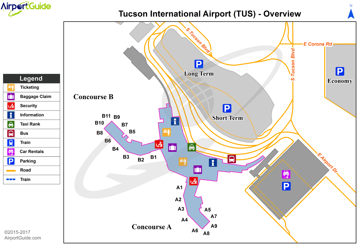
Maps & Diagrams
TUS Sectional
Flight Planning
at skyvector.com
at skyvector.com
 Diagram")