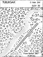
Location
Latitude: |
61-05-15.8200N (61.087728) |
Longitude: |
160-55-24.0700W (-160.923353) |
Elevation: |
35.8 feet MSL (11 m MSL) |
Magnetic Variation: |
10.2 E (as of April 2024 from WMM2020 model) |
Time Zone: |
UTC -9.0 (Standard Time) UTC -8.0 (Daylight Savings Time) |
From City: |
00 N.M. SSW of Tuluksak, Alaska |
Found On: |
Mc Grath Chart |
FAA Region: |
AAL |
Contacts
Manager: |
Publicly owned: |
| JOSEPH LARAUX BOX 505 BETHEL, AK 99559 (907) 543-2498 |
ALASKA DOT&PF CENTRAL REGION PO BOX 196900 ANCHORAGE, AK 99519-6900 907-269-0747 |
Operations
Airport Status: |
Operational |
Facility Use: |
Public |
Type: |
Airport |
Activation Date: |
10/1959 |
Control tower: |
No |
Attendance (Months/Days/Hours): |
Months/Days/Hours Unattended |
Boundary ARTCC: |
ZAN (Anchorage) |
Responsible ARTCC: |
ZAN (Anchorage) |
Lighting Schedule: |
SEE RMK |
Segmented Circle Indicator: |
Yes |
Traffic Pattern Altitude (MSL): |
1036 feet (316 m) |
NOTAMs Facility: |
ENA |
NOTAM-D Service: |
Yes |
International Airport of Entry: |
No |
Customs Landing Rights: |
No |
Military Landing Rights: |
Yes |
Civil/Military Joint Use: |
No |
Based Aircraft
Annual Operations (as of 12/31/2022)
| Total Operations: | 500 | |
| Air Taxi: | 500 | 100.0% |
Communications
| CTAF: | 122.900 |
Fixed Based Operators (FBOs) & Fuel
(Click on a business for detail)
Please help us keep this information up to date. This is a FREE SERVICE just like everything else on Airport Guide! If you see that a business needs to be added, modified, or deleted please fill out our Update Form.
To add, modify, or delete a business click here.
Please help us keep this information up to date. This is a FREE SERVICE just like everything else on Airport Guide! If you see that a business needs to be added, modified, or deleted please fill out our Update Form.
Area Code: 907 |
| Business Name | Frequency | Phone | Fuel Grade |
|---|
Flight Service Stations
| Primary | Alternate | |
| FSS on Field: | N | |
| FSS Name (ID): | Kenai(ENA) | |
| Frequency: | ||
| Toll Free Phone: | 1-866-864-1737 |
Instrument Procedures / Charts
Terminal Procedures are only available for airports in several countries with more being added all the time. If you are looking for a specific country's charts, please send an email to support(at)airportguide.com stating the country name. This will be used to prioritize the implementation.
Navigation Aids (Navaids) near TLT
| Dist (NM) | ID | Morse Code | Name | Type | Freq | True Hdg | Mag Hdg |
|---|---|---|---|---|---|---|---|
| 31.9 | BET | _ . . . . _ | Bethel | VORTAC | 114.10 | 235 | 225 |
| 32.9 | OSE | _ _ _ . . . . | Oscarville | NDB | 251 | 237 | 227 |
| 48.6 | ANI | . _ _ . . . | Aniak | NDB | 359 | 51 | 41 |
| 89.1 | SMA | . . . _ _ . _ | St Marys | NDB | 230 | 311 | 301 |
| 95.5 | ANV | . _ _ . . . . _ | Anvik | NDB | 365 | 12 | 2 |
Nearby Airports with Fuel
| Dist (NM) | Name (Airport IDs) | True Hdg | Mag Hdg | Fuel Grade |
|---|---|---|---|---|
| 32.5 | Bethel Airport (BET PABE BET) |
235 | 225 | 100, 100LL, Jet A, Jet A-1 |
| 49.5 | Aniak Airport (ANI PANI ANI) |
52 | 41 | 100LL, Jet A |
| 84.5 | Quinhagak Airport (KWN PAQH AQH) |
199 | 189 | 100LL |
| 92.6 | Crooked Creek Airport (CKD CJX) |
58 | 47 | MOGAS |
Notices to Airmen (NOTAMS)
Remarks
| A110-2 | RY COND NOT MONITORED; RCMD VISUAL INSPECTION PRIOR TO USE. |
| A110-7 | WX CAMERAS AVBL ON INTERNET AT HTTPS://WEATHERCAMS.FAA.GOV |
| A81-APT | ACTVT MIRL RY 15/33 - CTAF. |
| A81-BCN | ACTVT ROTG BCN - CTAF. |
Runways
Runway Summary
| Runways: | 15/33 |
| Longest Runway: | 15/33 is 3300 ft (1006 m) long |
| Runways with an Instrument Approach: |
TLT Airport Runway Details
| Runway 15/33 | 3300 ft x 60 ft (1006 m x 18 m) | |
| Runway Length Source: | STATE as of 11/27/2012 | |
| Surface: | Gravel/Dirt - Good condition - No special surface treatment | |
| Runway Edge Lights: | Medium Intensity | |
Runway 15 |
Runway 33 |
|
Elevation: |
35.8 | 35.8 |
Latitude: |
61-05-31.1100N | 61-05-00.5400N |
Longitude: |
160-55-35.4500W | 160-55-12.7000W |
Glide Path Angle: |
0.0 degrees | 0.0 degrees |
Runway Markings Type: |
Basic | Basic |
Runway Markings Condition: |
Good | Good |
Object at End: |
BRUSH | TREES |
Object Height: |
15 | 15 |
Distance from End: |
0 | 0 |
Object Centerline Offset: |
120 ft. left and right of centerline | 120 ft. left and right of centerline |
REIL: |
Yes | Yes |
Services
Fuel Available: |
MOGAS |
Landing Fees: |
No |
Maps & Diagrams
TLT Sectional
Flight Planning
at skyvector.com
at skyvector.com