Location
Latitude: |
62-31-13.4990N (62.520416) |
Longitude: |
164-50-51.5250W (-164.847646) |
Elevation: |
17.6 feet MSL (5 m MSL) |
Magnetic Variation: |
8.3 E (as of April 2024 from WMM2020 model) |
Time Zone: |
UTC -9.0 (Standard Time) UTC -8.0 (Daylight Savings Time) |
From City: |
00 N.M. S of Sheldon Point, Alaska |
Found On: |
Bethel Chart |
FAA Region: |
AAL |
Contacts
Manager: |
Publicly owned: |
| JOHN WILSON BOX 192 UNALAKLEET, AK 99684 (907) 625-1025 |
ALASKA DOT&PF NORTHERN REGION 2301 PEGER ROAD FAIRBANKS, AK 99709 907-451-2200 |
Operations
Airport Status: |
Operational |
Facility Use: |
Public |
Type: |
Airport |
Activation Date: |
06/1964 |
Control tower: |
No |
Attendance (Months/Days/Hours): |
Months/Days/Hours Unattended |
Boundary ARTCC: |
ZAN (Anchorage) |
Responsible ARTCC: |
ZAN (Anchorage) |
Lighting Schedule: |
SEE RMK |
Segmented Circle Indicator: |
Yes |
Traffic Pattern Altitude (MSL): |
1018 feet (310 m) |
NOTAMs Facility: |
ENA |
NOTAM-D Service: |
Yes |
International Airport of Entry: |
No |
Customs Landing Rights: |
No |
Civil/Military Joint Use: |
No |
Based Aircraft
Annual Operations (as of 12/31/2022)
| Total Operations: | 180 | |
| Air Taxi: | 180 | 100.0% |
Communications
| CTAF: | 122.900 |
Fixed Based Operators (FBOs) & Fuel
(Click on a business for detail)
Please help us keep this information up to date. This is a FREE SERVICE just like everything else on Airport Guide! If you see that a business needs to be added, modified, or deleted please fill out our Update Form.
To add, modify, or delete a business click here.
Please help us keep this information up to date. This is a FREE SERVICE just like everything else on Airport Guide! If you see that a business needs to be added, modified, or deleted please fill out our Update Form.
Area Code: 907 |
| Business Name | Frequency | Phone | Fuel Grade |
|---|
Flight Service Stations
| Primary | Alternate | |
| FSS on Field: | N | |
| FSS Name (ID): | Kenai(ENA) | |
| Frequency: | ||
| Toll Free Phone: | 1-866-864-1737 |
Instrument Procedures / Charts
Terminal Procedures are only available for airports in several countries with more being added all the time. If you are looking for a specific country's charts, please send an email to support(at)airportguide.com stating the country name. This will be used to prioritize the implementation.
Navigation Aids (Navaids) near SXP
| Dist (NM) | ID | Morse Code | Name | Type | Freq | True Hdg | Mag Hdg |
|---|---|---|---|---|---|---|---|
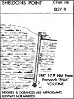
| 18.7 | ENM | . _ . _ _ | Emmonak | VOR-DME | 117.80 | 31 | 23 |
| 51.7 | SMA | . . . _ _ . _ | St Marys | NDB | 230 | 121 | 112 |
| 53.9 | CZF | _ . _ . _ _ . . . . _ . | Cape Romanzof | NDB | 275 | 216 | 208 |
| 55.8 | CZF | _ . _ . _ _ . . . . _ . | Cape Romanzof | DME | 116.75 | 217 | 209 |
| 70.4 | HPB | . . . . . _ _ . _ . . . | Hooper Bay | VOR-DME | 115.20 | 211 | 203 |
Nearby Airports with Fuel
| Dist (NM) | Name (Airport IDs) | True Hdg | Mag Hdg | Fuel Grade |
|---|
Notices to Airmen (NOTAMS)
Remarks
| A110-2 | RWY 02/20 CONDITIONS NOT MONITORED; VISUAL INSPECTION RECOMMENDED PRIOR TO LANDING. |
| A110-3 | BE ALERT: FLOATPLANE TFC USES RIVER NORTH OF ARPT. |
| A21 | SEAPLANE BASE ELEVATION: 0 FT MSL. |
| A30-09W/27W | RWY 09W/27W & 18W/36W FREQUENT STRONG WINDS IN THIS AREA, BE ALERT WHEN LANDING. WATER LANES NOT MONITORED OR MAINTAINED BY AK DOT&PF. |
| A33-02/20 | SOFT SPOTS MAY DEVELOPE DURING RAINY PERIODS & SPRING BREAK-UP. |
| A81-APT | ACTVT MIRL RWY 02/20 - CTAF. |
| A81-BCN | ROTG BCN OPER 24 HRS. |
Runways
Runway Summary
| Runways: | 02/20 09W/27W 18W/36W |
| Longest Runway: | 09W/27W is 15000 ft (4572 m) long |
| Runways with an Instrument Approach: |
SXP Airport Runway Details
| Runway 02/20 | 3016 ft x 60 ft (919 m x 18 m) | |
| Runway Length Source: | 3RD PARTY SURVEY as of 08/01/2019 | |
| Surface: | Gravel - Fair condition - No special surface treatment | |
| Runway Edge Lights: | Medium Intensity | |
Runway 02 |
Runway 20 |
|
Elevation: |
16.0 | 16.3 |
Latitude: |
62-31-00.2310N | 62-31-26.7656N |
Longitude: |
164-51-05.9493W | 164-50-37.0963W |
|
Runway True Alignment: |
027 | 207 |
Glide Path Angle: |
0.0 degrees | 0.0 degrees |
Object at End: |
BRUSH | BRUSH |
Object Height: |
2 | 2 |
Distance from End: |
0 | 0 |
Object Centerline Offset: |
0 ft. left and right of centerline | 20 ft. left and right of centerline |
| Runway 09W/27W | 15000 ft x 2000 ft (4572 m x 610 m) | |
| Surface: | Gravel - Fair condition - No special surface treatment | |
Runway 09W |
Runway 27W |
|
Elevation: |
0.0 | 0.0 |
Glide Path Angle: |
0.0 degrees | 0.0 degrees |
Traffic Pattern: |
Left | Left |
Object Centerline Offset: |
0 ft. left and right of centerline | 20 ft. left and right of centerline |
| Runway 18W/36W | 15000 ft x 2000 ft (4572 m x 610 m) | |
| Surface: | Gravel - Fair condition - No special surface treatment | |
Runway 18W |
Runway 36W |
|
Elevation: |
0.0 | 0.0 |
Glide Path Angle: |
0.0 degrees | 0.0 degrees |
Traffic Pattern: |
Left | Left |
Object Centerline Offset: |
0 ft. left and right of centerline | 20 ft. left and right of centerline |
Services
Airframe Repair: |
None |
Powerplant Repair: |
None |
Bottled Oxygen: |
None |
Bulk Oxygen: |
None |
Landing Fees: |
No |
Maps & Diagrams
SXP Sectional
Flight Planning
at skyvector.com
at skyvector.com