Location
Latitude: |
40-30-58.5390N (40.516261) |
Longitude: |
106-51-58.6860W (-106.866302) |
Elevation: |
6882.4 feet MSL (2098 m MSL) |
Magnetic Variation: |
8.7 E (as of April 2024 from WMM2020 model) |
Time Zone: |
UTC -7.0 (Standard Time) UTC -6.0 (Daylight Savings Time) |
From City: |
03 N.M. NW of Steamboat Springs, Colorado |
Found On: |
Cheyenne Chart |
FAA Region: |
ANM |
Contacts
Manager: |
Publicly owned: |
| STACIE FAIN PO BOX 775088 STEAMBOAT SPRINGS, CO 80477 970-879-1204 |
CITY OF STEAMBOAT SPRINGS PO BOX 775088 STEAMBOAT SPRINGS, CO 80477 970-879-1204 |
Operations
Airport Status: |
Operational |
Facility Use: |
Public |
Type: |
Airport |
Activation Date: |
01/1942 |
Control tower: |
No |
Attendance (Months/Days/Hours): |
Months/Days/Hours NOV-APR/ALL/0700-1700 |
Boundary ARTCC: |
ZDV (Denver) |
Responsible ARTCC: |
ZDV (Denver) |
Lighting Schedule: |
SEE RMK |
Segmented Circle Indicator: |
Yes |
Traffic Pattern Altitude (MSL): |
7882 feet (2402 m) |
NOTAMs Facility: |
SBS |
NOTAM-D Service: |
Yes |
International Airport of Entry: |
No |
Customs Landing Rights: |
No |
Military Landing Rights: |
No |
Civil/Military Joint Use: |
No |
Based Aircraft
| Single Engine: | 55 |
| Multi Engine: | 3 |
| Jet Engine: | 1 |
| GA Helicopters: | 1 |
| Gliders: | 1 |
| Ultralights: | 1 |
Annual Operations (as of 12/31/2018)
| Total Operations: | 12000 | |
| Air Taxi: | 551 | 4.6% |
| GA Local: | 9671 | 80.6% |
| GA Itinerant: | 1768 | 14.7% |
| Military Aircraft: | 10 | 0.1% |
Communications
| CTAF: | 122.800 |
| Unicom: | 122.800 |
| AWOS-3: | 118.325 (970-879-7794) |
- APCH/DEP CTL SVC PRVDD BY DENVER ARTCC (ZDV) FREQS 120.475/235.975 (HAYDEN RCAG).
- COMMUNICATIONS PRVDD BY DENVER RADIO ON FREQ 122.2 (STEAMBOAT SPRINGS RCO).
Fixed Based Operators (FBOs) & Fuel
(Click on a business for detail)
Please help us keep this information up to date. This is a FREE SERVICE just like everything else on Airport Guide! If you see that a business needs to be added, modified, or deleted please fill out our Update Form.
To add, modify, or delete a business click here.
Please help us keep this information up to date. This is a FREE SERVICE just like everything else on Airport Guide! If you see that a business needs to be added, modified, or deleted please fill out our Update Form.
Area Code: 970 |
| Business Name | Frequency | Phone | Fuel Grade |
|---|---|---|---|
| City of Steamboat Springs
Update FBO info |
Unicom 122.8 | 879-1204 | 100LL, Jet A |
| Mountain Flight Services
Update FBO info |
879-0936 | ||
| Steamboat Flight Academy
Update FBO info |
870-7644 |
Flight Service Stations
| Primary | Alternate | |
| FSS on Field: | N | |
| FSS Name (ID): | Denver(DEN) | |
| Frequency: | ||
| Toll Free Phone: | 1-800-WX-BRIEF |
Instrument Procedures / Charts
FAA Terminal Procedures valid from 0901Z 03/21/24 to 0901Z 04/18/24.
There are various types of charts available for an airport. They are listed in the Page Type column. Here is a legend for those types:
APD - Airport Diagram
DP - Departure Procedure Charts
HOT - Hot Spots
IAP - Instrument Approach Procedure Charts
MIN - Minimums
STAR - Standard Terminal Arrival Charts
| Page Type | Page Name | Volume | Action Since Last Cycle |
|---|---|---|---|
| IAP | RNAV (GPS) Z RWY 32 | SW-1 | Added |
| IAP | RNAV (GPS)-E | SW-1 | Changed |
| IAP | VOR/DME-C | SW-1 | Changed |
| MIN | ALTERNATE MINIMUMS | SW-1 | Changed |
| MIN | TAKEOFF MINIMUMS | SW-1 |
Terminal Procedures are only available for airports in several countries with more being added all the time. If you are looking for a specific country's charts, please send an email to support(at)airportguide.com stating the country name. This will be used to prioritize the implementation.
Navigation Aids (Navaids) near SBS
| Dist (NM) | ID | Morse Code | Name | Type | Freq | True Hdg | Mag Hdg |
|---|---|---|---|---|---|---|---|
| 3.2 | BQZ | _ . . . _ _ . _ _ _ . . | Robert | VOR-DME | 112.20 | 184 | 175 |
| 20.0 | CHE | _ . _ . . . . . . | Hayden | VOR-DME | 115.60 | 270 | 261 |
| 36.4 | RLG | . _ . . _ . . _ _ . | Kremmling | VOR-DME | 113.80 | 147 | 138 |
| 53.5 | SXW | . . . _ . . _ . _ _ | Snow | VOR-DME | 109.20 | 186 | 177 |
| 55.4 | EKR | . _ . _ . _ . | Meeker | VOR-DME | 115.20 | 241 | 232 |
| 55.7 | SAA | . . . . _ . _ | Saratoga | NDB | 266 | 1 | 352 |
| 64.6 | DBL | _ . . _ . . . . _ . . | Red Table | VOR-DME | 113.00 | 181 | 172 |
| 71.1 | RIL | . _ . . . . _ . . | Rifle | VOR-DME | 113.35 | 213 | 204 |
| 71.6 | LAR | . _ . . . _ . _ . | Laramie | VOR-DME | 117.60 | 46 | 38 |
| 78.2 | RDY | . _ . _ . . _ . _ _ | Sardy | TACAN | 114.30 | 179 | 170 |
| 78.8 | RWL | . _ . . _ _ . _ . . | Rawlins | VOR-DME | 109.40 | 348 | 339 |
| 81.1 | CKW | _ . _ . _ . _ . _ _ | Cherokee | VOR-DME | 115.00 | 336 | 327 |
| 87.0 | FN | . . _ . _ . | Colln | NDB | 400 | 95 | 87 |
| 87.0 | BJC | _ . . . . _ _ _ _ . _ . | Jeffco | VOR-DME | 115.40 | 114 | 106 |
| 88.7 | MBW | _ _ _ . . . . _ _ | Medicine Bow | VOR-DME | 116.85 | 25 | 16 |
Nearby Airports with Fuel
Notices to Airmen (NOTAMS)
Remarks
| A110-4 | WILDLIFE ON & INVOF ARPT. |
| A110-5 | COLD TEMPERATURE AIRPORT. ALTITUDE CORRECTION REQUIRED AT OR BELOW -26C. |
| A110-6 | FOR CD IF UNA TO CTC ON FSS FREQ, CTC DENVER ARTCC AT 303-651-4257. |
| A110-7 | SI NA TO AVOID TFC CONFLICTS. |
| A24 | NO LDG FEE FOR SNGL ENG PISTON ACFT. |
| A30A-32 | PREFERRED RWY; 180 FT DROPOFF 2000 FT FM PAVEMENT END. |
| A43-32 | PAPI BAFFLED; VIS LMTD TO 5.5 DEGS LEFT OF CNTRLN DUE TO HIGH TRRN. |
| A81-APT | ACTVT REIL RWY 32; PAPI RWY 32; HIRL RWY 14/32 - CTAF. |
| A82 | UNICOM AVBL 0700-1700. |
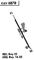
Runways
Runway Summary
| Runways: | 14/32 |
| Longest Runway: | 14/32 is 4452 ft (1357 m) long |
| Runways with an Instrument Approach: |
SBS Airport Runway Details
| Runway 14/32 | 4452 ft x 100 ft (1357 m x 30 m) | |
| Runway Length Source: | 3RD PARTY SURVEY as of 12/09/2019 | |
| Surface: | Asphalt - Good condition - Saw-cut or plastic grooved | |
| Runway Edge Lights: | High Intensity | |
Runway Weight Bearing Capacity (in thousands of pounds) |
||
| Single Wheel Landing Gear: | 50.0 | |
| Dual Wheel Landing Gear: | 60.0 | |
Runway 14 |
Runway 32 |
|
Elevation: |
6874.7 | 6882.1 |
Latitude: |
40-31-18.1109N | 40-30-38.9661N |
Longitude: |
106-52-11.8196W | 106-51-45.5538W |
|
Runway True Alignment: |
153 | 333 |
Glide Path Angle: |
0.0 degrees | 4.0 degrees |
Traffic Pattern: |
Right | Left |
Runway Markings Type: |
Basic | Nonprecision Instrument |
Runway Markings Condition: |
Fair | Fair |
Visual Glide Slope Indicators: |
2-Light PAPI On Left Side Of Runway | |
REIL: |
Yes | |
Threshold Crossing Height: |
40 | |
Threshold Elevation: |
6881.1 | |
Displaced Threshold: |
600 | |
Threshold Latitude: |
40-30-44.2431N | |
Threshold Longitude: |
106-51-49.0879W | |
Declared Distances |
||
Take Off Run Avbl. (TORA): |
4452 | 4452 |
Take Off Distance Avbl. (TODA): |
4452 | 4452 |
Actual Stop Dist. Avbl. (ASDA): |
3852 | 4452 |
Landing Dist. Avbl. (LDA): |
3852 | 3852 |
Services
Airframe Repair: |
None |
Powerplant Repair: |
None |
Bottled Oxygen: |
None |
Bulk Oxygen: |
None |
Fuel Available: |
100LL |
Landing Fees: |
No |
Parking: |
Tiedowns available |
Other Services: |
Aviation College |
Maps & Diagrams
SBS Sectional
Flight Planning
at skyvector.com
at skyvector.com