Location
Latitude: |
36-22-20.7000N (36.372417) |
Longitude: |
094-06-25.1000W (-94.106972) |
Elevation: |
1358.8 feet MSL (414 m MSL) |
Magnetic Variation: |
0.9 E (as of April 2024 from WMM2020 model) |
Time Zone: |
UTC -6.0 (Standard Time) UTC -5.0 (Daylight Savings Time) |
From City: |
02 N.M. N of Rogers, Arkansas |
Found On: |
Kansas City Chart |
FAA Region: |
ASW |
Contacts
Manager: |
Publicly owned: |
| DAVID KRUTSCH #3 SOUTH AIRPORT DRIVE ROGERS, AR 72756 479-631-1400 |
CITY OF ROGERS 301 WEST CHESTNUT ROGERS, AR 72756 (479) 631-1400 |
Operations
Airport Status: |
Operational |
Facility Use: |
Public |
Type: |
Airport |
Activation Date: |
05/1946 |
Control tower: |
Yes |
Attendance (Months/Days/Hours): |
Months/Days/Hours ALL/MON-FRI/0400-2100 |
Boundary ARTCC: |
ZME (Memphis) |
Responsible ARTCC: |
ZME (Memphis) |
Lighting Schedule: |
SEE RMK |
Segmented Circle Indicator: |
Yes |
Traffic Pattern Altitude (MSL): |
2359 feet (719 m) |
NOTAMs Facility: |
ROG |
NOTAM-D Service: |
Yes |
International Airport of Entry: |
No |
Customs Landing Rights: |
No |
Military Landing Rights: |
Yes |
Civil/Military Joint Use: |
No |
Based Aircraft
| Single Engine: | 88 |
| Multi Engine: | 6 |
| Jet Engine: | 28 |
Annual Operations (as of 02/28/2023)
| Total Operations: | 32000 | |
| Air Taxi: | 2000 | 6.2% |
| GA Local: | 5000 | 15.6% |
| GA Itinerant: | 25000 | 78.1% |
Communications
| CTAF: | 119.375 |
| Tower: | ROGERS 119.375 Hrs: 0530-1930 MON-FRI; 0800-1900 SAT-SUN |
| Clearance Del.: | 121.75 121.75 ;WHEN TWR CLSD 121.75 ;WHEN TWR CLSD 121.75 ;WHEN TWR CLSD |
| Ground: | 118.0 |
| Approach: | RAZORBACK MEMPHIS ARTCC |
| Departure: | RAZORBACK MEMPHIS ARTCC |
| AWOS-3PT: | 134.375 (479-631-9196) |
- APCH/DEP SVC PRVDD BY MEMPHIS ARTCC ON FREQS 126.1/269.0 (FAYETTEVILLE RCAG) WHEN RAZORBACK APCH CTL CLSD.
Fixed Based Operators (FBOs) & Fuel
(Click on a business for detail)
Please help us keep this information up to date. This is a FREE SERVICE just like everything else on Airport Guide! If you see that a business needs to be added, modified, or deleted please fill out our Update Form.
To add, modify, or delete a business click here.
Please help us keep this information up to date. This is a FREE SERVICE just like everything else on Airport Guide! If you see that a business needs to be added, modified, or deleted please fill out our Update Form.
Area Code: 501 |
| Business Name | Frequency | Phone | Fuel Grade |
|---|---|---|---|
| Beaver Lake Aviation
Update FBO info |
Unicom 122.875 | 636-9400 | 100ll, jet a |
| Rogers Aviation
Update FBO info |
Unicom 123.0 | 631-1626, -1627 | 100LL, Jet A |
Flight Service Stations
| Primary | Alternate | |
| FSS on Field: | N | |
| FSS Name (ID): | Jonesboro(JBR) | |
| Frequency: | ||
| Toll Free Phone: | 1-800-WX-BRIEF |
Instrument Procedures / Charts
FAA Terminal Procedures valid from 0901Z 03/21/24 to 0901Z 04/18/24.
There are various types of charts available for an airport. They are listed in the Page Type column. Here is a legend for those types:
APD - Airport Diagram
DP - Departure Procedure Charts
HOT - Hot Spots
IAP - Instrument Approach Procedure Charts
MIN - Minimums
STAR - Standard Terminal Arrival Charts
| Page Type | Page Name | Volume | Action Since Last Cycle |
|---|---|---|---|
| APD | AIRPORT DIAGRAM | SC-1 | |
| DP | ROGERS FOUR | SC-1 | |
| IAP | ILS OR LOC RWY 20 | SC-1 | |
| IAP | RNAV (GPS) RWY 02 | SC-1 | |
| IAP | RNAV (GPS) RWY 20 | SC-1 | |
| MIN | ALTERNATE MINIMUMS | SC-1 | |
| MIN | TAKEOFF MINIMUMS | SC-1 |
Terminal Procedures are only available for airports in several countries with more being added all the time. If you are looking for a specific country's charts, please send an email to support(at)airportguide.com stating the country name. This will be used to prioritize the implementation.
Navigation Aids (Navaids) near ROG
| Dist (NM) | ID | Morse Code | Name | Type | Freq | True Hdg | Mag Hdg |
|---|---|---|---|---|---|---|---|
| 5.6 | RO | . _ . _ _ _ | Rogrs | NDB | 263 | 18 | 17 |
| 7.6 | RZC | . _ . _ _ . . _ . _ . | Razorback | VORTAC | 116.40 | 185 | 184 |
| 20.3 | DAK | _ . . . _ _ . _ | Drake | DME | 115.25 | 192 | 191 |
| 21.5 | SLG | . . . . _ . . _ _ . | Siloam Springs | NDB | 284 | 239 | 238 |
| 32.3 | EOS | . _ _ _ . . . | Neosho | DME | 117.3 | 330 | 329 |
| 43.3 | HRO | . . . . . _ . _ _ _ | Harrison | VOR-DME | 112.50 | 94 | 93 |
| 47.1 | HR | . . . . . _ . | Bakky | NDB | 395 | 103 | 102 |
| 51.1 | TQH | _ _ _ . _ . . . . | Tahlequah | NDB | 215 | 238 | 237 |
| 54.4 | JL | . _ _ _ . _ . . | Lunns | NDB | 344 | 336 | 335 |
| 59.6 | FSM | . . _ . . . . _ _ | Fort Smith | VORTAC | 110.40 | 187 | 186 |
| 61.3 | FS | . . _ . . . . | Wizer | NDB | 223 | 185 | 184 |
| 63.6 | CZE | _ . _ . _ _ . . . | Clarksville | NDB | 201 | 148 | 147 |
| 65.5 | GK | _ _ . _ . _ | Jembo | NDB | 311 | 195 | 194 |
| 67.3 | IQS | . . _ _ . _ . . . | Sallisaw | NDB | 520 | 209 | 208 |
| 67.7 | LLU | . _ . . . _ . . . . _ | Spring River | NDB | 356 | 351 | 350 |
| 69.7 | SGF | . . . _ _ . . . _ . | Springfield | VORTAC | 116.90 | 31 | 30 |
| 70.7 | OSW | _ _ _ . . . . _ _ | Oswego | DME | 117.6 | 312 | 311 |
| 70.8 | PTS | . _ _ . _ . . . | Pittsburg | NDB | 365 | 335 | 334 |
| 70.9 | DGD | _ . . _ _ . _ . . | Dogwood | VORTAC | 109.40 | 56 | 56 |
| 79.8 | FLP | . . _ . . _ . . . _ _ . | Flippin | DME | 116.05 | 92 | 92 |
Nearby Airports with Fuel
Notices to Airmen (NOTAMS)
Remarks
| A110-1 | ARFF AVBL UPON REQUEST. |
| A110-2 | RY 20 DESIGNATED CALM WIND RY. |
| A110-5 | BIRD ACTIVITY ON & INVOF ARPT. |
| A110-7 | DEER AND COYOTE ON & INVOF ARPT. |
| A110-8 | FOR CD WHEN UNA VIA FREQ CTC RAZORBACK APCH 479-649-2416, WHEN APCH CLSD CTC MEMPHIS ARTCC AT 901-368-8453/8449. |
| A70-FUEL-10 | 0LL FOR FUEL AFT HRS CALL 479-636-9400; FEE CHARGED. |
| A81-APT | WHEN ATCT CLSD ACTVT HIRL RY 02/20, REIL RY 02, TWY LGTS & MALSR RY 20, PAPI RY 02&20- CTAF. |
| E80 | US CUSTOMS USER FEE ARPT. |
Runways
Runway Summary
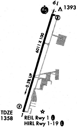
| Runways: | 02/20 |
| Longest Runway: | 02/20 is 6011 ft (1832 m) long |
| Runways with an Instrument Approach: | 20 |
ROG Airport Runway Details
| Runway 02/20 | 6011 ft x 100 ft (1832 m x 30 m) | |
| Runway Length Source: | 3RD PARTY SURVEY as of 08/28/2008 | |
| Surface: | Asphalt - Good condition - Saw-cut or plastic grooved | |
| Runway Pavement Class: | 42 /F/B/X/T | |
| Runway Edge Lights: | High Intensity | |
Runway Weight Bearing Capacity (in thousands of pounds) |
||
| Single Wheel Landing Gear: | 45.0 | |
| Dual Wheel Landing Gear: | 100.0 | |
Runway 02 |
Runway 20 |
|
Elevation: |
1358.7 | 1339.9 |
Latitude: |
36-21-52.6003N | 36-22-48.7487N |
Longitude: |
094-06-37.1355W | 094-06-13.0148W |
|
Runway True Alignment: |
019 | 199 |
ILS Type: |
ILS/DME | |
Glide Path Angle: |
3.0 degrees | 3.0 degrees |
Traffic Pattern: |
Left | Left |
Runway Markings Type: |
Precision Instrument | Precision Instrument |
Runway Markings Condition: |
Good | Good |
Visual Glide Slope Indicators: |
4-Light PAPI On Left Side Of Runway | 4-Light PAPI On Left Side Of Runway |
Approach Light System: |
1,400 Foot Medium Intensity Approach Lighting System With Runway Alignment Indicator Lights | |
REIL: |
Yes | |
Threshold Crossing Height: |
55 | 55 |
Services
Fuel Available: |
100LL, Jet A |
Landing Fees: |
No |
Parking: |
Hangars and tiedowns available |
Maps & Diagrams
ROG Sectional
Flight Planning
at skyvector.com
at skyvector.com