Location
Latitude: |
41-35-39.2000N (41.594222) |
Longitude: |
109-03-54.7000W (-109.065194) |
Elevation: |
6764.6 feet MSL (2062 m MSL) |
Magnetic Variation: |
9.9 E (as of April 2024 from WMM2020 model) |
Time Zone: |
UTC -7.0 (Standard Time) UTC -6.0 (Daylight Savings Time) |
From City: |
07 N.M. E of Rock Springs, Wyoming |
Found On: |
Salt Lake City Chart |
FAA Region: |
ANM |
Contacts
Manager: |
Publicly owned: |
| DEVON BRUBAKER 382 HWY 370 ROCK SPRINGS, WY 82901-1987 307-352-6880 |
ROCK SPRINGS/SWEETWATER COUNTY BOX 1987 ROCK SPRINGS, WY 82902-1987 307-352-6880 |
Operations
Airport Status: |
Operational |
Facility Use: |
Public |
Type: |
Airport |
Activation Date: |
07/1942 |
Control tower: |
No |
Attendance (Months/Days/Hours): |
Months/Days/Hours ALL/ALL/0400-2200 |
Boundary ARTCC: |
ZLC (Salt Lake City) |
Responsible ARTCC: |
ZLC (Salt Lake City) |
Lighting Schedule: |
SEE RMK |
Segmented Circle Indicator: |
Yes |
Traffic Pattern Altitude (MSL): |
7765 feet (2367 m) |
NOTAMs Facility: |
RKS |
NOTAM-D Service: |
Yes |
International Airport of Entry: |
No |
Customs Landing Rights: |
No |
Military Landing Rights: |
Yes |
Civil/Military Joint Use: |
No |
Aircraft Rescue and Firefighting: |
Class I ARFF Index: A Air Carrier Service: Scheduled Certification Date: 05/1973 |
Based Aircraft
| Single Engine: | 35 |
| Multi Engine: | 5 |
| GA Helicopters: | 1 |
| Ultralights: | 3 |
Annual Operations (as of 01/01/2019)
| Total Operations: | 16674 | |
| Commercial: | 24 | 0.1% |
| Air Taxi: | 4550 | 27.3% |
| GA Local: | 2275 | 13.6% |
| GA Itinerant: | 9770 | 58.6% |
| Military Aircraft: | 55 | 0.3% |
Communications
| CTAF: | 122.800 |
| Unicom: | 122.800 |
| ASOS: | 118.375 (307-362-2541) |
- COMMUNICATIONS PRVDD BY CASPER RADIO ON FREQ 122.2 (ROCK SPRINGS RCO).
- APCH/DEP CTL SVC PRVDD BY SALT LAKE ARTCC (ZLC) ON 124.35/353.5 (GREEN RIVER RCAG).
Fixed Based Operators (FBOs) & Fuel
(Click on a business for detail)
Please help us keep this information up to date. This is a FREE SERVICE just like everything else on Airport Guide! If you see that a business needs to be added, modified, or deleted please fill out our Update Form.
To add, modify, or delete a business click here.
Please help us keep this information up to date. This is a FREE SERVICE just like everything else on Airport Guide! If you see that a business needs to be added, modified, or deleted please fill out our Update Form.
Area Code: 307 |
| Business Name | Frequency | Phone | Fuel Grade |
|---|---|---|---|
| Airport Management
Update FBO info |
Unicom 122.8 | 352-6888 | 100ll, Jet A |
Flight Service Stations
| Primary | Alternate | |
| FSS on Field: | ||
| FSS Name (ID): | Casper(CPR) | |
| Frequency: | ||
| Toll Free Phone: | 1-800-WX-BRIEF |
Instrument Procedures / Charts
FAA Terminal Procedures valid from 0901Z 03/21/24 to 0901Z 04/18/24.
There are various types of charts available for an airport. They are listed in the Page Type column. Here is a legend for those types:
APD - Airport Diagram
DP - Departure Procedure Charts
HOT - Hot Spots
IAP - Instrument Approach Procedure Charts
MIN - Minimums
STAR - Standard Terminal Arrival Charts
| Page Type | Page Name | Volume | Action Since Last Cycle |
|---|---|---|---|
| APD | AIRPORT DIAGRAM | NW-1 | |
| IAP | ILS OR LOC RWY 27 | NW-1 | |
| IAP | RNAV (GPS) RWY 09 | NW-1 | |
| IAP | RNAV (GPS) RWY 27 | NW-1 | |
| IAP | VOR RWY 09 | NW-1 | |
| IAP | VOR/DME RWY 27 | NW-1 | |
| MIN | ALTERNATE MINIMUMS | NW-1 | |
| MIN | TAKEOFF MINIMUMS | NW-1 |
Terminal Procedures are only available for airports in several countries with more being added all the time. If you are looking for a specific country's charts, please send an email to support(at)airportguide.com stating the country name. This will be used to prioritize the implementation.
Navigation Aids (Navaids) near RKS
| Dist (NM) | ID | Morse Code | Name | Type | Freq | True Hdg | Mag Hdg |
|---|---|---|---|---|---|---|---|
| 2.3 | OCS | _ _ _ _ . _ . . . . | Rock Springs | VOR-DME | 116.00 | 96 | 86 |
| 62.4 | FBR | . . _ . _ . . . . _ . | Fort Bridger | VOR-DME | 114.45 | 258 | 248 |
| 67.2 | CKW | _ . _ . _ . _ . _ _ | Cherokee | VOR-DME | 115.00 | 81 | 71 |
| 75.2 | BPI | _ . . . . _ _ . . . | Big Piney | VOR-DME | 116.50 | 322 | 312 |
| 75.5 | VEL | . . . _ . . _ . . | Vernal | VOR-DME | 108.20 | 195 | 185 |
| 79.1 | PNA | . _ _ . _ . . _ | Wenz | NDB | 392 | 335 | 325 |
| 84.3 | RWL | . _ . . _ _ . _ . . | Rawlins | VOR-DME | 109.40 | 80 | 71 |
| 91.2 | EVW | . . . . _ . _ _ | Evanston | VOR-DME | 109.60 | 258 | 248 |
| 92.3 | RIW | . _ . . . . _ _ | Riverton | VOR-DME | 114.05 | 16 | 6 |
| 99.2 | MTU | _ _ _ . . _ | Myton | VOR-DME | 112.70 | 209 | 199 |
Nearby Airports with Fuel
| Dist (NM) | Name (Airport IDs) | True Hdg | Mag Hdg | Fuel Grade |
|---|---|---|---|---|
| 43.2 | Dutch John Airport (33U) |
199 | 189 | 100LL |
| 61.4 | Fort Bridger Airport (FBR KFBR FBR) |
259 | 249 | 100LL |
| 68.2 | Kemmerer Municipal Airport (EMM KEMM EMM) |
282 | 272 | 100LL, Jet A |
| 72.4 | Vernal Regional Airport (VEL KVEL VEL) |
196 | 186 | 100LL, Jet A |
| 74.8 | Hunt Field Airport (LND KLND LND) |
11 | 1 | 100LL, Jet A |
| 75.3 | Miley Meml Field Airport (BPI KBPI BPI) |
322 | 312 | 100LL, Jet A |
| 79.4 | Ralph Wenz Field Airport (KPNA PNA) |
335 | 325 | 100LL, Jet A |
| 84.5 | Rawlins Municipal/Harvey Field Airport (RWL KRWL RWL) |
80 | 71 | 100LL, Jet A |
| 90.6 | Evanston-Uinta County Burns Field Airport (EVW KEVW EVW) |
258 | 247 | 100LL, Jet A |
| 90.7 | Roosevelt Municipal Airport (74V) |
209 | 199 | 100LL, Jet A |
| 91.1 | Rangely Airport (RNG 4V0) |
171 | 162 | 100LL |
| 92.2 | Central Wyoming Regional Airport (RIW KRIW RIW) |
16 | 6 | 100LL, Jet A |
| 96.1 | Craig-Moffat Airport (CIG KCAG CAG) |
132 | 123 | 100LL, Jet A |
Notices to Airmen (NOTAMS)
Remarks
| A11 | ROCK SPRINGS/SWEETWATER CO ARPT JOINT PWRS BOARDS |
| A110-1 | FOR CD IF UNA TO CTC ON FSS FREQ, CTC SALT LAKE ARTCC AT 801-320-2568. |
| A26 | PPR FOR ACR OPNS WITH MORE THAN 30 PAX SEATS 0430-2200 CALL ARPT OPS 307-352-6888. ARFF INDEX C AVBL WITH 30 MIN NOTICE: CALL ARPT OPS 307-352-6888. |
| A81-APT | ACTVT MALSR RWY 27; ODALS RWY 09; REIL RWY 03 & 21; HIRL RWY 09/27 AND TWY LGTS - CTAF. PAPI RWY 09, 27, 03, 21 OPR CONSLY. |
| E111 | EXISTED PRIOR TO 1959. |
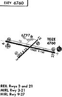
Runways
Runway Summary
| Runways: | 03/21 09/27 |
| Longest Runway: | 09/27 is 10000 ft (3048 m) long |
| Runways with an Instrument Approach: | 27 |
RKS Airport Runway Details
| Runway 03/21 | 5228 ft x 75 ft (1593 m x 23 m) | |
| Runway Length Source: | 3RD PARTY SURVEY as of 12/13/2012 | |
| Surface: | Asphalt - Good condition - Porous friction course | |
| Runway Pavement Class: | 27 /F/A/X/T | |
| Runway Edge Lights: | Medium Intensity | |
Runway Weight Bearing Capacity (in thousands of pounds) |
||
| Single Wheel Landing Gear: | 59.0 | |
| Dual Wheel Landing Gear: | 88.0 | |
| Dual Tandem Wheel Landing Gear: | 159.0 | |
Runway 03 |
Runway 21 |
|
Elevation: |
6733.9 | 6748.0 |
Latitude: |
41-35-18.7692N | 41-35-55.1484N |
Longitude: |
109-04-24.3878W | 109-03-35.5686W |
|
Runway True Alignment: |
045 | 225 |
Glide Path Angle: |
3.0 degrees | 3.0 degrees |
Runway Markings Type: |
Basic | Basic |
Runway Markings Condition: |
Good | Good |
Visual Glide Slope Indicators: |
2-Light PAPI On Left Side Of Runway | 2-Light PAPI On Left Side Of Runway |
REIL: |
Yes | Yes |
Threshold Crossing Height: |
30 | 30 |
Declared Distances |
||
Take Off Run Avbl. (TORA): |
5228 | 5228 |
Take Off Distance Avbl. (TODA): |
5228 | 5228 |
Actual Stop Dist. Avbl. (ASDA): |
5228 | 5228 |
Landing Dist. Avbl. (LDA): |
5228 | 5228 |
| Runway 09/27 | 10000 ft x 150 ft (3048 m x 46 m) | |
| Runway Length Source: | 3RD PARTY SURVEY as of 12/13/2012 | |
| Surface: | Asphalt - Good condition - Saw-cut or plastic grooved | |
| Runway Pavement Class: | 63 /F/A/X/T | |
| Runway Edge Lights: | High Intensity | |
Runway Weight Bearing Capacity (in thousands of pounds) |
||
| Single Wheel Landing Gear: | 55.0 | |
| Dual Wheel Landing Gear: | 240.0 | |
| Dual Tandem Wheel Landing Gear: | 503.0 | |
Runway 09 |
Runway 27 |
|
Elevation: |
6731.7 | 6764.5 |
Latitude: |
41-35-51.6292N | 41-35-29.0562N |
Longitude: |
109-04-56.0139W | 109-02-47.9285W |
|
Runway True Alignment: |
103 | 283 |
ILS Type: |
ILS/DME | |
Glide Path Angle: |
3.0 degrees | 3.0 degrees |
Traffic Pattern: |
Left | Left |
Runway Markings Type: |
Precision Instrument | Precision Instrument |
Runway Markings Condition: |
Good | Good |
Visual Glide Slope Indicators: |
4-Light PAPI On Left Side Of Runway | 4-Light PAPI On Left Side Of Runway |
Approach Light System: |
Omnidirectional Approach Lighting System | 1,400 Foot Medium Intensity Approach Lighting System With Runway Alignment Indicator Lights |
Threshold Crossing Height: |
50 | 55 |
Declared Distances |
||
Take Off Run Avbl. (TORA): |
10000 | 10000 |
Take Off Distance Avbl. (TODA): |
10000 | 10000 |
Actual Stop Dist. Avbl. (ASDA): |
10000 | 10000 |
Landing Dist. Avbl. (LDA): |
10000 | 10000 |
Services
Bottled Oxygen: |
None |
Bulk Oxygen: |
None |
Fuel Available: |
100LL, Jet A |
Landing Fees: |
No |
Parking: |
Tiedowns available |
Maps & Diagrams
RKS Sectional
Flight Planning
at skyvector.com
at skyvector.com