Location
Latitude: |
69-43-58.4000N (69.732889) |
Longitude: |
163-00-19.2000W (-163.005333) |
Elevation: |
28.5 feet MSL (9 m MSL) |
Magnetic Variation: |
8.5 E (as of April 2024 from WMM2020 model) |
Time Zone: |
UTC -9.0 (Standard Time) UTC -8.0 (Daylight Savings Time) |
From City: |
01 N.M. S of Point Lay, Alaska |
Found On: |
Cape Lisburne Chart |
FAA Region: |
AAL |
Contacts
Manager: |
Publicly owned: |
| GEORGE AHMAOGAK, JR PO BOX 69 BARROW, AK 99723 (907) 852-0489 |
US GOV 11TCW/LGO ELEMDORF 6900 9TH ST SUITE 301 EAFB, AK 99506 907-557-4146 |
Operations
Airport Status: |
Operational |
Facility Use: |
Public |
Type: |
Airport |
Activation Date: |
03/1960 |
Control tower: |
No |
Attendance (Months/Days/Hours): |
Months/Days/Hours ALL/ALL/ALL |
Boundary ARTCC: |
ZAN (Anchorage) |
Responsible ARTCC: |
ZAN (Anchorage) |
Lighting Schedule: |
SEE RMK |
Segmented Circle Indicator: |
Yes |
Traffic Pattern Altitude (MSL): |
1028 feet (313 m) |
NOTAMs Facility: |
PIZ |
NOTAM-D Service: |
Yes |
International Airport of Entry: |
No |
Customs Landing Rights: |
No |
Military Landing Rights: |
Yes |
Civil/Military Joint Use: |
No |
Based Aircraft
Annual Operations (as of 12/31/2020)
| Total Operations: | 208 | |
| Air Taxi: | 156 | 75.0% |
| Military Aircraft: | 52 | 25.0% |
Communications
| CTAF: | 122.800 |
| AWOS-3P: | 135.65 (907-833-3112) |
- APCH/DEP SVC PRVDD BY ANCHORAGE ARTCC ON FREQS 119.65/363.25 (CAPE LISBURNE RCAG).
- COMMUNICATIONS PRVDD BY BARROW FSS ON FREQ 122.40 (POINT LAY RCO).
Fixed Based Operators (FBOs) & Fuel
(Click on a business for detail)
Please help us keep this information up to date. This is a FREE SERVICE just like everything else on Airport Guide! If you see that a business needs to be added, modified, or deleted please fill out our Update Form.
To add, modify, or delete a business click here.
Please help us keep this information up to date. This is a FREE SERVICE just like everything else on Airport Guide! If you see that a business needs to be added, modified, or deleted please fill out our Update Form.
Area Code: 907 |
| Business Name | Frequency | Phone | Fuel Grade |
|---|
Flight Service Stations
| Primary | Alternate | |
| FSS on Field: | N | |
| FSS Name (ID): | Barrow(BRW) | Fairbanks (FAI) |
| Frequency: | ||
| Toll Free Phone: | LC852-2511 | 1-866-248-6516 |
Instrument Procedures / Charts
FAA Terminal Procedures valid from 0901Z 03/21/24 to 0901Z 04/18/24.
There are various types of charts available for an airport. They are listed in the Page Type column. Here is a legend for those types:
APD - Airport Diagram
DP - Departure Procedure Charts
HOT - Hot Spots
IAP - Instrument Approach Procedure Charts
MIN - Minimums
STAR - Standard Terminal Arrival Charts
| Page Type | Page Name | Volume | Action Since Last Cycle |
|---|---|---|---|
| IAP | NDB RWY 05 | AK-1 | |
| IAP | RNAV (GPS) RWY 05 | AK-1 | Changed |
| IAP | RNAV (GPS) RWY 23 | AK-1 | Changed |
Terminal Procedures are only available for airports in several countries with more being added all the time. If you are looking for a specific country's charts, please send an email to support(at)airportguide.com stating the country name. This will be used to prioritize the implementation.
Navigation Aids (Navaids) near PIZ
| Dist (NM) | ID | Morse Code | Name | Type | Freq | True Hdg | Mag Hdg |
|---|---|---|---|---|---|---|---|
| 0.3 | PIZ | . _ _ . . . _ _ . . | Point Lay | NDB | 362 | 40 | 32 |
| 81.6 | UKK | . . _ _ . _ _ . _ | Wainwright Village | NDB | 338 | 46 | 37 |
| 83.1 | LUR | . _ . . . . _ . _ . | Cape Lisburne | NDB-DME | 385 | 232 | 224 |
Nearby Airports with Fuel
| Dist (NM) | Name (Airport IDs) | True Hdg | Mag Hdg | Fuel Grade |
|---|
Notices to Airmen (NOTAMS)
Remarks
| A110-5 | WX CAMERA AVBL ON INTERNET AT HTTPS://WEATHERCAMS.FAA.GOV |
| A110-6 | BARROW FSS - 1-800-779-7709 OR 907-852-2511. |
| A110-7 | COLD TEMPERATURE AIRPORT. ALTITUDE CORRECTION REQUIRED AT OR BELOW -33C. |
| A81-APT | ACTVT REIL RWY 05 & 23; PAPI RWY 05 & 23; MIRL RWY 05/23 - CTAF. |
| A81-BCN | ACTVT ROTG BCN - CTAF. |
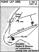
Runways
Runway Summary
| Runways: | 05/23 |
| Longest Runway: | 05/23 is 4500 ft (1372 m) long |
| Runways with an Instrument Approach: |
PIZ Airport Runway Details
| Runway 05/23 | 4500 ft x 100 ft (1372 m x 30 m) | |
| Runway Length Source: | 3RD PARTY SURVEY as of 08/08/2010 | |
| Surface: | Gravel - Good condition - No special surface treatment | |
| Runway Edge Lights: | Medium Intensity | |
Runway 05 |
Runway 23 |
|
Elevation: |
28.5 | 17.8 |
Latitude: |
69-43-50.3000N | 69-44-06.4100N |
Longitude: |
163-01-18.6900W | 162-59-19.7600W |
|
Runway True Alignment: |
069 | 249 |
Glide Path Angle: |
3.0 degrees | 3.0 degrees |
Traffic Pattern: |
Left | Left |
Object at End: |
ROAD | |
Object Height: |
15 | |
Distance from End: |
400 | |
Visual Glide Slope Indicators: |
4-Light PAPI On Left Side Of Runway | 4-Light PAPI On Left Side Of Runway |
REIL: |
Yes | Yes |
Touchdown Lights: |
No | No |
Centerline Lights: |
No | No |
Threshold Crossing Height: |
35 | 35 |
Services
Landing Fees: |
No |
Parking: |
Hangars available |
Maps & Diagrams
PIZ Sectional
Flight Planning
at skyvector.com
at skyvector.com