Location
Latitude: |
27-54-31.0810N (27.908634) |
Longitude: |
082-41-11.4360W (-82.68651) |
Elevation: |
10.7 feet MSL (3 m MSL) |
Magnetic Variation: |
5.9 W (as of April 2024 from WMM2020 model) |
Time Zone: |
UTC -5.0 (Standard Time) UTC -4.0 (Daylight Savings Time) |
From City: |
08 N.M. N of St. Petersburg-Clearwater, Florida |
Found On: |
Miami Chart |
FAA Region: |
ASO |
Contacts
Manager: |
Publicly owned: |
| THOMAS JEWSBURY ST PETE-CLEARWATER INTERNATIONAL CLEARWATER, FL 33762 727-453-7800 |
COUNTY OF PINELLAS ST. PETE-CLEARWATER INTERNATIONAL, TERMINAL BLVD. SUITE 221 CLEARWATER, FL 33762 727-453-7800 |
Operations
Airport Status: |
Operational |
Facility Use: |
Public |
Type: |
Airport |
Activation Date: |
10/1942 |
Control tower: |
Yes |
Attendance (Months/Days/Hours): |
Months/Days/Hours ALL/ALL/ALL |
Boundary ARTCC: |
ZMA (Miami) |
Responsible ARTCC: |
ZMA (Miami) |
Lighting Schedule: |
SEE RMK |
Segmented Circle Indicator: |
No |
Traffic Pattern Altitude (MSL): |
1011 feet (308 m) |
NOTAMs Facility: |
PIE |
NOTAM-D Service: |
Yes |
International Airport of Entry: |
No |
Customs Landing Rights: |
Yes |
Military Landing Rights: |
Yes |
Civil/Military Joint Use: |
No |
Aircraft Rescue and Firefighting: |
Class I ARFF Index: C Air Carrier Service: Scheduled Certification Date: 11/1974 |
Based Aircraft
| Single Engine: | 154 |
| Multi Engine: | 45 |
| Jet Engine: | 59 |
| GA Helicopters: | 3 |
| Military Aircraft: | 18 |
Annual Operations (as of 12/31/2023)
| Total Operations: | 165665 | |
| Commercial: | 15480 | 9.3% |
| Air Taxi: | 19979 | 12.1% |
| GA Local: | 77940 | 47.0% |
| GA Itinerant: | 44717 | 27.0% |
| Military Aircraft: | 7549 | 4.6% |
Communications
| CTAF: | 118.300 |
| Unicom: | 122.950 |
| Tower: | ST. PETERSBURG-CLEARWATER 118.3 257.8 128.4 Hrs: 0600-2300 |
| Clearance Del.: | 120.6 350.2 |
| Ground: | 121.9 348.6 |
| Approach: | TAMPA |
| Departure: | TAMPA |
| ATIS: | 134.5 Hrs: 24 |
| ASOS: | 134.5 (727-531-3456) |
Fixed Based Operators (FBOs) & Fuel
(Click on a business for detail)
Please help us keep this information up to date. This is a FREE SERVICE just like everything else on Airport Guide! If you see that a business needs to be added, modified, or deleted please fill out our Update Form.
To add, modify, or delete a business click here.
Please help us keep this information up to date. This is a FREE SERVICE just like everything else on Airport Guide! If you see that a business needs to be added, modified, or deleted please fill out our Update Form.
Area Code: 727 |
| Business Name | Frequency | Phone | Fuel Grade |
|---|---|---|---|
| Image Aviation Services
Update FBO info |
542-9164 | ||
| Jet Executive Center-Avitat
Update FBO info |
530-3453 | 100LL, Jet A | |
| Signature Flight Support
Website Update FBO info |
Unicom 122.95, Arinc 130.375 | +1 727 531 1441 | 100LL, Jet A |
| TSA Helicopters
Website Update FBO info |
727-535-8210 |
Flight Service Stations
| Primary | Alternate | |
| FSS on Field: | N | |
| FSS Name (ID): | Saint Petersburg(PIE) | |
| Frequency: | ||
| Toll Free Phone: | 1-800-WX-BRIEF |
Instrument Procedures / Charts
FAA Terminal Procedures valid from 0901Z 03/21/24 to 0901Z 04/18/24.
There are various types of charts available for an airport. They are listed in the Page Type column. Here is a legend for those types:
APD - Airport Diagram
DP - Departure Procedure Charts
HOT - Hot Spots
IAP - Instrument Approach Procedure Charts
MIN - Minimums
STAR - Standard Terminal Arrival Charts
Terminal Procedures are only available for airports in several countries with more being added all the time. If you are looking for a specific country's charts, please send an email to support(at)airportguide.com stating the country name. This will be used to prioritize the implementation.
Navigation Aids (Navaids) near PIE
| Dist (NM) | ID | Morse Code | Name | Type | Freq | True Hdg | Mag Hdg |
|---|---|---|---|---|---|---|---|
| 0.1 | PIE | . _ _ . . . . | St Petersburg | VORTAC | 116.40 | 113 | 119 |
| 5.3 | PI | . _ _ . . . | Capok | NDB | 360 | 349 | 355 |
| 8.0 | AM | . _ _ _ | Picny | NDB | 388 | 110 | 116 |
| 9.1 | TPA | _ . _ _ . . _ | Tampa Intl | VOT | 111.00 | 64 | 70 |
| 9.6 | MCF | _ _ _ . _ . . . _ . | Macdill | TACAN | 111.00 | 107 | 113 |
| 13.6 | TP | _ . _ _ . | Cosme | NDB | 368 | 38 | 44 |
| 30.8 | SRQ | . . . . _ . _ _ . _ | Sarasota | VOR-DME | 117.00 | 167 | 173 |
| 33.9 | RHZ | . _ . . . . . _ _ . . | Zephyrhills | NDB | 253 | 55 | 61 |
| 36.0 | LAL | . _ . . . _ . _ . . | Lakeland | VORTAC | 116.00 | 82 | 88 |
| 52.6 | VNC | . . . _ _ . _ . _ . | Venice | NDB | 206 | 164 | 170 |
| 70.1 | PGD | . _ _ . _ _ . _ . . | Punta Gorda | VOR | 110.20 | 147 | 153 |
| 71.6 | LEE | . _ . . . . | Leesburg | NDB | 335 | 40 | 46 |
| 75.3 | OR | _ _ _ . _ . | Herny | NDB | 221 | 61 | 67 |
| 79.9 | OCF | _ _ _ _ . _ . . . _ . | Ocala | VORTAC | 113.70 | 17 | 23 |
| 80.9 | ORL | _ _ _ . _ . . _ . . | Orlando | VORTAC | 112.20 | 61 | 67 |
| 92.3 | FM | . . _ . _ _ | Caloo | NDB | 341 | 154 | 160 |
| 92.6 | SFB | . . . . . _ . _ . . . | Sanford | NDB | 408 | 55 | 61 |
| 94.7 | LBV | . _ . . _ . . . . . . _ | La Belle | VORTAC | 110.40 | 132 | 138 |
| 95.9 | RSW | . _ . . . . . _ _ | Lee County | VORTAC | 114.15 | 149 | 155 |
Nearby Airports with Fuel
Notices to Airmen (NOTAMS)
Remarks
| A110-10 | BANNER TOWING NA. |
| A110-11 | BIRDS ON & INVOF ARPT. |
| A110-12 | FOR CD IF UNA TO CTC ON FSS FREQ, CTC TAMPA APCH AT 813-878-2528. |
| A110-2 | NOISE SENSITIVE AREA 5 MI N EXTDG 1 MI E & W OF LOC SB TO SHORELINE. |
| A110-3 | MILITARY: CONTRACT AVOIL O-128 AVBL. |
| A110-4 | TBJT LNDG RWY 18 & DEP RWY 36 USE PUBLD NOISE ABATEMENT PROC. |
| A110-8 | LGTS ON HWY N OF ARPT MAY BE MISTAKEN FOR RWY LGTS. |
| A57-22 | APCH RATIO 34:1 TO THR. |
| A57-36 | APCH RATIO 50:1 TO DTHR. |
| A58-36 | 6 FT FENCE 200 FT BFR AER 483 FT R OF CNTRLN. |
| A81-APT | WHEN ATCT CLSD ACTVT MALSR RWY 18; TDZ RWY 18; CNTLN RWY 18/36; MIRL RWY 04/22; HIRL RWY 18/36; TWY LGTS - CTAF. |
Runways
Runway Summary
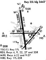
| Runways: | 04/22 18/36 |
| Longest Runway: | 18/36 is 9730 ft (2966 m) long |
| Runways with an Instrument Approach: | 18, 36 |
PIE Airport Runway Details
| Runway 04/22 | 6000 ft x 150 ft (1829 m x 46 m) | |
| Runway Length Source: | 3RD PARTY SURVEY as of 06/19/2020 | |
| Surface: | Asphalt - Fair condition - Saw-cut or plastic grooved | |
| Runway Pavement Class: | 32 /F/B/X/T | |
| Runway Edge Lights: | Medium Intensity | |
Runway Weight Bearing Capacity (in thousands of pounds) |
||
| Single Wheel Landing Gear: | 80.0 | |
| Dual Wheel Landing Gear: | 130.0 | |
| Dual Tandem Wheel Landing Gear: | 235.0 | |
Runway 04 |
Runway 22 |
|
Elevation: |
10.7 | 5.1 |
Latitude: |
27-53-59.1642N | 27-54-44.8565N |
Longitude: |
082-41-21.6028W | 082-40-38.8614W |
|
Runway True Alignment: |
040 | 220 |
Glide Path Angle: |
3.0 degrees | 3.0 degrees |
Traffic Pattern: |
Left | Left |
Runway Markings Type: |
Nonprecision Instrument | Nonprecision Instrument |
Runway Markings Condition: |
Good | Good |
Object at End: |
TREES | ROAD |
Object Height: |
32 | 8 |
Distance from End: |
1135 | 270 |
Object Centerline Offset: |
10 ft. left of centerline | 250 ft. left of centerline |
Visual Glide Slope Indicators: |
4-Light PAPI On Left Side Of Runway | 4-Light PAPI On Left Side Of Runway |
REIL: |
Yes | Yes |
Threshold Crossing Height: |
57 | 45 |
Declared Distances |
||
Take Off Run Avbl. (TORA): |
6000 | 6000 |
Take Off Distance Avbl. (TODA): |
6000 | 6000 |
Actual Stop Dist. Avbl. (ASDA): |
6000 | 6000 |
Landing Dist. Avbl. (LDA): |
6000 | 6000 |
| Runway 18/36 | 9730 ft x 150 ft (2966 m x 46 m) | |
| Runway Length Source: | 3RD PARTY SURVEY as of 06/19/2020 | |
| Surface: | Asphalt - Fair condition - Saw-cut or plastic grooved | |
| Runway Pavement Class: | 74 /F/A/W/T | |
| Runway Edge Lights: | High Intensity | |
Runway Weight Bearing Capacity (in thousands of pounds) |
||
| Single Wheel Landing Gear: | 75.0 | |
| Dual Wheel Landing Gear: | 195.0 | |
| Dual Tandem Wheel Landing Gear: | 320.0 | |
| Dual Dual Tandem Wheel Landing Gear: | 700.0 | |
Runway 18 |
Runway 36 |
|
Elevation: |
6.6 | 9.8 |
Latitude: |
27-55-24.2937N | 27-53-49.0536N |
Longitude: |
082-41-26.5381W | 082-41-10.1518W |
|
Runway True Alignment: |
171 | 351 |
ILS Type: |
ILS/DME | ILS/DME |
Glide Path Angle: |
3.0 degrees | 3.0 degrees |
Traffic Pattern: |
Left | Left |
Runway Markings Type: |
Precision Instrument | Precision Instrument |
Runway Markings Condition: |
Fair | Fair |
Object at End: |
BRUSH | TREE |
Object Height: |
9 | 30 |
Distance from End: |
665 | 450 |
Object Centerline Offset: |
10 ft. left of centerline | 250 ft. left of centerline |
Visual Glide Slope Indicators: |
4-Light PAPI On Left Side Of Runway | 4-Light PAPI On Left Side Of Runway |
Runway Visual Range (RVR): |
Touchdown, Midfield, Rollout | Touchdown, Midfield, Rollout |
Approach Light System: |
1,400 Foot Medium Intensity Approach Lighting System With Runway Alignment Indicator Lights | |
REIL: |
No | No |
Touchdown Lights: |
Yes | No |
Centerline Lights: |
Yes | Yes |
Threshold Crossing Height: |
68 | 76 |
Threshold Elevation: |
9.8 | |
Displaced Threshold: |
930 | |
Threshold Latitude: |
27-53-58.1598N | |
Threshold Longitude: |
082-41-11.7182W | |
Declared Distances |
||
Take Off Run Avbl. (TORA): |
9730 | 9730 |
Take Off Distance Avbl. (TODA): |
9730 | 9730 |
Actual Stop Dist. Avbl. (ASDA): |
9180 | 9650 |
Landing Dist. Avbl. (LDA): |
9180 | 8720 |
Services
Airframe Repair: |
Major |
Powerplant Repair: |
Major |
Bottled Oxygen: |
None |
Bulk Oxygen: |
None |
Fuel Available: |
100LL, Jet A+ |
Landing Fees: |
No |
Parking: |
Hangars and tiedowns available |
Maps & Diagrams

PIE Sectional
Flight Planning
at skyvector.com
at skyvector.com