Location
Latitude: |
44-16-14.0000N (44.270556) |
Longitude: |
123-03-43.0000W (-123.061944) |
Elevation: |
320.0 feet MSL (98 m MSL) |
Magnetic Variation: |
14.6 E (as of April 2024 from WMM2020 model) |
Time Zone: |
UTC -8.0 (Standard Time) UTC -7.0 (Daylight Savings Time) |
From City: |
05 N.M. E of Harrisburg, Oregon |
Found On: |
Klamath Falls Chart |
FAA Region: |
ANM |
Contacts
Manager: |
Privately owned: |
| MARTY NILL PO BOX 279 JUNCTION CITY, OR 97448 (541) 953-5684 |
SHANNON & MARTY NILL PO BOX 279 JUNCTION CITY, OR 97448 541-998-4053 |
Operations
Airport Status: |
Operational |
Facility Use: |
Private |
Type: |
Airport |
Control tower: |
No |
Attendance (Months/Days/Hours): |
Months/Days/Hours UNATTND |
Boundary ARTCC: |
ZSE (Seattle) |
Responsible ARTCC: |
ZSE (Seattle) |
Segmented Circle Indicator: |
No |
Traffic Pattern Altitude (MSL): |
1320 feet (402 m) |
NOTAM-D Service: |
No |
International Airport of Entry: |
No |
Customs Landing Rights: |
No |
Military Landing Rights: |
No |
Civil/Military Joint Use: |
No |
Based Aircraft
| Single Engine: | 24 |
Annual Operations (as of )
Communications
Fixed Based Operators (FBOs) & Fuel
(Click on a business for detail)
Please help us keep this information up to date. This is a FREE SERVICE just like everything else on Airport Guide! If you see that a business needs to be added, modified, or deleted please fill out our Update Form.
To add, modify, or delete a business click here.
Please help us keep this information up to date. This is a FREE SERVICE just like everything else on Airport Guide! If you see that a business needs to be added, modified, or deleted please fill out our Update Form.
Area Code: 503 |
| Business Name | Frequency | Phone | Fuel Grade |
|---|
Flight Service Stations
| Primary | Alternate | |
| FSS on Field: | N | |
| FSS Name (ID): | Mc Minnville(MMV) | |
| Frequency: | ||
| Toll Free Phone: | 1-800-WX-BRIEF |
Instrument Procedures / Charts
Terminal Procedures are only available for airports in several countries with more being added all the time. If you are looking for a specific country's charts, please send an email to support(at)airportguide.com stating the country name. This will be used to prioritize the implementation.
Navigation Aids (Navaids) near OR78
| Dist (NM) | ID | Morse Code | Name | Type | Freq | True Hdg | Mag Hdg |
|---|---|---|---|---|---|---|---|
| 7.6 | EU | . . . _ | Frakk | NDB | 260 | 243 | 228 |
| 11.3 | EUG | . . . _ _ _ . | Eugene | VORTAC | 112.90 | 217 | 202 |
| 17.0 | CVO | _ . _ . . . . _ _ _ _ | Corvallis | VOR-DME | 115.40 | 324 | 309 |
| 22.4 | LWG | . _ . . . _ _ _ _ . | Lewisburg | NDB | 225 | 336 | 321 |
| 34.9 | SL | . . . . _ . . | Turno | NDB | 266 | 7 | 352 |
| 46.5 | ONP | _ _ _ _ . . _ _ . | Newport | VORTAC | 117.10 | 293 | 278 |
| 63.4 | RBG | . _ . _ . . . _ _ . | Roseburg | NDB | 400 | 191 | 177 |
| 65.1 | UBG | . . _ _ . . . _ _ . | Newberg | VOR-DME | 117.40 | 3 | 348 |
| 66.5 | RBG | . _ . _ . . . _ _ . | Roseburg | VOR-DME | 108.20 | 191 | 177 |
| 70.2 | OTH | _ _ _ _ . . . . | North Bend | VOR-DME | 112.10 | 223 | 208 |
| 75.4 | OT | _ _ _ _ | Emire | NDB | 378 | 226 | 211 |
| 75.6 | DSD | _ . . . . . _ . . | Deschutes | VORTAC | 117.60 | 90 | 76 |
| 76.4 | HIO | . . . . . . _ _ _ | Hillsboro | VOT | 115.20 | 3 | 348 |
| 80.4 | LBH | . _ . . _ . . . . . . . | Laker | NDB | 332 | 18 | 3 |
| 81.4 | CBU | _ . _ . _ . . . . . _ | Columbia | TACAN | 109.20 | 13 | 358 |
| 81.6 | PND | . _ _ . _ . _ . . | Banks | NDB | 356 | 0 | 345 |
| 81.7 | PDX | . _ _ . _ . . _ . . _ | Portland | VOR-DME | 111.80 | 13 | 358 |
| 81.9 | PDX | . _ _ . _ . . _ . . _ | Portland | VOT | 111.00 | 13 | 358 |
| 87.8 | RD | . _ . _ . . | Bodey | NDB | 411 | 87 | 73 |
| 90.9 | BTG | _ . . . _ _ _ . | Battle Ground | VORTAC | 116.60 | 12 | 357 |
Nearby Airports with Fuel
Notices to Airmen (NOTAMS)
Remarks
| A110-1 | UNICOM 122.9. |
| A110-2 | LANDING ON GRASS NOT PERMITTED DURING THE 6 MONTHS FROM NOV - APR DUE TO WET GROUND. |
| A110-3 | ALL PILOTS USING FACILITY ARE OPERATING AT YOUR OWN RISK. |
| A110-4 | FOR CD CTC CASCADE APCH AT 541-607-4674/4675, WHEN APCH CLSD CTC SEATTLE ARTCC AT 253-351-3694. |
| A16 | ADD'L PHONE 1-541-343-1386 |
| A31-16/34 | <850' OVRN NORTH END & 470' OVRN SOUTH END RWY 16/34. |
| A52-16 | AND 100' SIGN 2000' N OF N END. |
| E111 | NO OBJ PROVIDED RWY 16 THR IS DSPLCD TO PROVIDE 15' HWY CLNC USING 40-1 SLOPE. |
Runways
Runway Summary
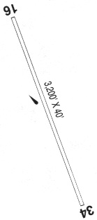
| Runways: | 16/34 |
| Longest Runway: | 16/34 is 3000 ft (914 m) long |
| Runways with an Instrument Approach: |
OR78 Airport Runway Details
| Runway 16/34 | 3000 ft x 40 ft (914 m x 12 m) | |
| Surface: | Turf/Gravel - No special surface treatment | |
Runway 16 |
Runway 34 |
|
Glide Path Angle: |
0.0 degrees | 0.0 degrees |
Traffic Pattern: |
Left | Right |
Object at End: |
FIELD | BRUSH |
Distance from End: |
500 | 400 |
Services
Powerplant Repair: |
None |
Bottled Oxygen: |
None |
Bulk Oxygen: |
None |
Fuel Available: |
100LL, Jet A, Jet A+ |
Landing Fees: |
No |
Parking: |
Hangars and tiedowns available |
Maps & Diagrams
OR78 Sectional
Flight Planning
at skyvector.com
at skyvector.com