
Location
Latitude: |
37-43-16.5410N (37.721261) |
Longitude: |
122-13-16.1420W (-122.221151) |
Elevation: |
9.0 feet MSL (3 m MSL) |
Magnetic Variation: |
13 E (as of April 2024 from WMM2020 model) |
Time Zone: |
UTC -8.0 (Standard Time) UTC -7.0 (Daylight Savings Time) |
From City: |
04 N.M. S of Oakland, California |
Found On: |
San Francisco Chart |
FAA Region: |
AWP |
Contacts
Manager: |
Publicly owned: |
| MATT DAVIS METROPOLITAN OAKLAND INTL ARPT OAKLAND, CA 94621 510-563-6436 |
PORT OF OAKLAND 530 WATER ST. OAKLAND, CA 94607 510-563-3300 |
Operations
Airport Status: |
Operational |
Facility Use: |
Public |
Type: |
Airport |
Activation Date: |
04/1940 |
Control tower: |
Yes |
Attendance (Months/Days/Hours): |
Months/Days/Hours ALL/ALL/ALL |
Boundary ARTCC: |
ZOA (Oakland) |
Responsible ARTCC: |
ZOA (Oakland) |
Segmented Circle Indicator: |
No |
Traffic Pattern Altitude (MSL): |
1009 feet (308 m) |
NOTAMs Facility: |
OAK |
NOTAM-D Service: |
Yes |
International Airport of Entry: |
No |
Customs Landing Rights: |
Yes |
Military Landing Rights: |
Yes |
Civil/Military Joint Use: |
No |
Aircraft Rescue and Firefighting: |
Class I ARFF Index: D Air Carrier Service: Scheduled Certification Date: 05/1973 |
Based Aircraft
| Single Engine: | 162 |
| Multi Engine: | 24 |
| Jet Engine: | 71 |
| GA Helicopters: | 7 |
Annual Operations (as of 04/30/2023)
| Total Operations: | 228188 | |
| Commercial: | 127920 | 56.1% |
| Air Taxi: | 29644 | 13.0% |
| GA Local: | 38637 | 16.9% |
| GA Itinerant: | 31147 | 13.6% |
| Military Aircraft: | 840 | 0.4% |
Communications
| Unicom: | 122.950 |
| Tower: | OAKLAND 118.3 ;RWY 10L/28R, 10R/28L, 15/33 127.2 ;RWY 12/30 256.9 ;RWY 12/30 291.65 ;RWY 10L/28R, 10R/28L, 15/33 124.9 Hrs: 24 |
| Clearance Del.: | 121.1 |
| Ground: | 121.75 ;RWY 12/30 121.9 ;RWY 10L/28R, 10R/28L, 15/33 |
| Approach: | NORCAL |
| Departure: | NORCAL |
| ATIS: | 133.775 Hrs: 24 |
| ASOS: | (510-214-1776) |
| EMERG: | 243.0 |
- MASTER (NCT) ARPT PRVDS CLASS B SVC FOR SAN FRANCISCO INTL.
- FREQ 121.5/243.0 NOT AVBL AT ATCT.
Fixed Based Operators (FBOs) & Fuel
(Click on a business for detail)
Please help us keep this information up to date. This is a FREE SERVICE just like everything else on Airport Guide! If you see that a business needs to be added, modified, or deleted please fill out our Update Form.
To add, modify, or delete a business click here.
Please help us keep this information up to date. This is a FREE SERVICE just like everything else on Airport Guide! If you see that a business needs to be added, modified, or deleted please fill out our Update Form.
Area Code: 510 |
| Business Name | Frequency | Phone | Fuel Grade |
|---|---|---|---|
| Airweld General Aviation
Update FBO info |
568-5822 | ||
| Alameda Aero Club
Update FBO info |
638-4149 | ||
| Bay Avionics
Update FBO info |
638-1056 | ||
| Earhart Aeromedical Center
Update FBO info |
633-7623 | ||
| Fields Flying School
Update FBO info |
635-3752 | ||
| Frank Grinnon Simulator Training
Update FBO info |
569-5288 | ||
| KaiserAir, Inc.
Update FBO info |
Unicom 122.95, Arinc 131.725 | 569-9622 | 100LL, Jet A |
| Link Services
Update FBO info |
430-8422 | ||
| Oakland Flyers
Update FBO info |
568-3317 | ||
| Pilots Computer Aviation Technology
Update FBO info |
632-6763 | ||
| Sierra Academy of Aeronautics
Update FBO info |
568-6100 | ||
| Signature Flight Support
Update FBO info |
Unicom: 122.95, Arinc: 130.575 | +1 510 633 1266 | |
| Tower Aviation Service
Update FBO info |
635-3500 |
Flight Service Stations
| Primary | Alternate | |
| FSS on Field: | N | |
| FSS Name (ID): | Oakland(OAK) | |
| Frequency: | ||
| Toll Free Phone: | 1-800-WX-BRIEF |
Instrument Procedures / Charts
FAA Terminal Procedures valid from 0901Z 03/21/24 to 0901Z 04/18/24.
There are various types of charts available for an airport. They are listed in the Page Type column. Here is a legend for those types:
APD - Airport Diagram
DP - Departure Procedure Charts
HOT - Hot Spots
IAP - Instrument Approach Procedure Charts
MIN - Minimums
STAR - Standard Terminal Arrival Charts
Terminal Procedures are only available for airports in several countries with more being added all the time. If you are looking for a specific country's charts, please send an email to support(at)airportguide.com stating the country name. This will be used to prioritize the implementation.
Navigation Aids (Navaids) near OAK
| Dist (NM) | ID | Morse Code | Name | Type | Freq | True Hdg | Mag Hdg |
|---|---|---|---|---|---|---|---|
| 0.3 | OAK | _ _ _ . _ _ . _ | Oakland | VOR-DME | 116.80 | 337 | 324 |
| 9.2 | SFO | . . . . . _ . _ _ _ | San Francisco | VOT | 111.00 | 228 | 215 |
| 9.5 | SFO | . . . . . _ . _ _ _ | San Francisco | VOR-DME | 115.80 | 229 | 216 |
| 16.4 | SAU | . . . . _ . . _ | Sausalito | VOR-DME | 116.20 | 299 | 286 |
| 19.0 | NUQ | _ . . . _ _ _ . _ | Moffett | TACAN | 117.60 | 155 | 142 |
| 19.9 | OSI | _ _ _ . . . . . | Woodside | VOR-DME | 113.90 | 188 | 175 |
| 21.1 | CCR | _ . _ . _ . _ . . _ . | Concord | VOR-DME | 117.00 | 23 | 10 |
| 21.4 | CC | _ . _ . _ . _ . | Kanan | NDB | 335 | 24 | 11 |
| 24.6 | SJC | . . . . _ _ _ _ . _ . | San Jose | VOR-DME | 114.10 | 147 | 134 |
| 25.6 | LV | . _ . . . . . _ | Reiga | NDB | 374 | 93 | 80 |
| 28.4 | SGD | . . . _ _ . _ . . | Scaggs Island | VORTAC | 112.10 | 345 | 332 |
| 34.1 | SUU | . . . . . _ . . _ | Travis | TACAN | 116.60 | 22 | 9 |
| 36.9 | TCY | _ _ . _ . _ . _ _ | Tracy | NDB | 203 | 92 | 79 |
| 37.4 | PYE | . _ _ . _ . _ _ . | Point Reyes | VOR-DME | 113.70 | 305 | 292 |
| 42.1 | TZZ | _ _ _ . . _ _ . . | Travis | VOR | 116.40 | 27 | 14 |
| 50.2 | ECA | . _ . _ . . _ | Manteca | VOR-DME | 116.00 | 81 | 68 |
| 51.3 | WVI | . _ _ . . . _ . . | Watsonville | DME | 114.25 | 155 | 142 |
| 52.3 | PDG | . _ _ . _ . . _ _ . | Pajar | NDB | 327 | 157 | 144 |
| 53.7 | SAC | . . . . _ _ . _ . | Sacramento | VORTAC | 115.20 | 35 | 22 |
| 54.8 | STS | . . . _ . . . | Santa Rosa | DME | 116.15 | 329 | 316 |
Nearby Airports with Fuel
Notices to Airmen (NOTAMS)
Remarks
| A110-1 | BIRDS ON & INVOF ARPT. |
| A110-11 | RWYS 30, 28R AND RWY 28L DIST RMNG SIGNS L SIDE. |
| A110-12 | FOR NOISE ABATEMENT INFO CTC NOISE ABATEMENT OFC AT (510) 563-6463. |
| A110-15 | RWY 15/33 CLSD TO ACR ACFT. |
| A110-17 | PREFERENTIAL RWY USE PROGRAM IN EFFECT 2200-0600. NORTH FLD PREF ARR RWY 28L, NORTH FLD PREF DEP RWYS 10R OR 28R. IF THESE RWYS UNACCEPTABLE FOR SAFETY OR ATC INSTRN THEN RWY 12/30 MUST BE USED. |
| A110-20 | 24 HR NOISE ABATEMENT PROCEDURE - TBJT AND TURBOFAN PWRD ACFT, TURBOROPS OVER 17,000 LBS, FOUR-ENGINE RECIPROCATING PWRD ACFT, AND SURPLUS MIL ACFT OVER 12,500 POUNDS SHOULD NOT DEP RWYS 28L & 28R OR LAND ON RWYS 10R & 10L. |
| A110-22 | TWY A, E, G, H BTN RWY 28R AND TWY C MAX ACFT WT 150,000 LBS. |
| A110-23 | TWY G & H BTN RWY 28L & 28R: MAX ACFT WT 12,500 LBS. |
| A110-24 | TWY P MAX ACFT WT 116,000 LBS SINGLE; 190,000 LBS DUAL; 305,000 LBS DUAL TANDEM; 735,000 LBS DOUBLE DUAL TANDEM. |
| A110-25 | TWY C BTN RWY 28R & TWY G AND TWYS B, J, AND D MAX ACFT WT 861,000 LBS. |
| A110-26 | TWY C BTN TWY G & J MAX ACFT WEIGHT 90,000 LBS SINGLE; 144,000 LBS DUAL; 257,000 LBS TANDEM. |
| A110-27 | TWY C BTN TWY J & F MAX ACFT WEIGHT 76,000 LBS SINGLE; 115,000 LBS DUAL; 257,000 LBS TANDEM (DUAL TANDEM NA). |
| A110-28 | TWY K BTN TWY D & INT TWYS F, L, K MAX ACFT WEIGHT 56,000 LBS SINGLE; 70,000 LBS DUAL; 130,000 LBS TANDEM. |
| A110-29 | TWY K BTN TWY J AND INT TWYS F, L, K MAX ACFT WT 33000 LBS SINGLE; 45000 LBS DUAL; TANDEM NA. |
| A110-3 | 400 FT BY 220 FT BLAST PAD RWY 12 AND RWY 30. |
| A110-30 | UNDERLIES CLASS B ASP, BE AWARE OF SPEEDS ON ARR AND DEP. |
| A110-6 | NOISE ABATEMENT PROCS N/A IN EMERGS OR WHENEVER RWY 12/30 IS CLSD DUE TO MAINT, SAFETY, WINDS OR WX. |
| A110-7 | ACFT WITH EXPERIMENTAL OR LTD CERTIF HAVING OVER 1000 HORSEPOWER OR 4000 LBS ARE RSTRD TO RWY 12/30. |
| A110-9 | 100 FT LGTD MICROWAVE ANT TWR LCTD 1320 FT WSW OF OAK VORTAC; S OF UPWIND END OF RWY 28L. |
| A14 | OPERATIONS - DARRON EVANS, OPNS SUPERINTENDENT (510)563-6432, CELL: (510) 715-6286 24HR OPERATIONS (510) 563-3361. |
| A24 | LDG FEE IN EFCT 24 HRS/DAY, CTC AIRFIELD OPS (510) 563-3361. |
| A26 | RWY 15/33 NOT AVBL FOR SKED ACR OPNS WITH MORE THAN 9 PSGR SEATS OR UNSKED ACR AT LEAST 31 PSGR SEATS. |
| A39-10L/28R | PCR VALUE: 1266/F/B/X/T |
| A39-10R/28L | PCR VALUE: 934/F/B/X/T |
| A39-12/30 | PCR VALUE: 1295/F/B/X/T |
| E147 | TFC PAT ALT RWY 28L 606' MSL; RWY 28R 1006' MSL. |
| E60-28L | ENGINEERED MATERIALS ARRESTING SYSTEM (EMAS) 162 FT IN LENGTH BY 154 FT IN WIDTH LCTD AT THE DER 28L. |
Runways
Runway Summary
| Runways: | 10L/28R 10R/28L 12/30 15/33 |
| Longest Runway: | 12/30 is 10520 ft (3206 m) long |
| Runways with an Instrument Approach: | 28R, 12, 30 |
OAK Airport Runway Details
| Runway 10L/28R | 5457 ft x 150 ft (1663 m x 46 m) | |
| Runway Length Source: | 3RD PARTY SURVEY as of 08/31/2020 | |
| Surface: | Asphalt - Good condition - Saw-cut or plastic grooved | |
| Runway Edge Lights: | High Intensity | |
Runway Weight Bearing Capacity (in thousands of pounds) |
||
| Single Wheel Landing Gear: | 120.0 | |
| Dual Wheel Landing Gear: | 250.0 | |
| Dual Tandem Wheel Landing Gear: | 550.0 | |
| Dual Dual Tandem Wheel Landing Gear: | 1120.0 | |
Runway 10L |
Runway 28R |
|
Elevation: |
5.5 | 5.8 |
Latitude: |
37-43-49.6892N | 37-43-29.3324N |
Longitude: |
122-13-19.8482W | 122-12-16.9514W |
|
Runway True Alignment: |
112 | 292 |
ILS Type: |
ILS | |
Glide Path Angle: |
3.0 degrees | 3.0 degrees |
Traffic Pattern: |
Left | Right |
Runway Markings Type: |
Nonprecision Instrument | Precision Instrument |
Runway Markings Condition: |
Good | Good |
Object at End: |
BLDG | |
Object Height: |
11 | |
Object Marked/Lighted?: |
Lighted | |
Distance from End: |
530 | |
Object Centerline Offset: |
480 ft. right of centerline | |
Visual Glide Slope Indicators: |
4-Light PAPI On Right Side Of Runway | 4-Light PAPI On Left Side Of Runway |
Runway Visual Range (RVR): |
Rollout | Touchdown |
Approach Light System: |
1,400 Foot Medium Intensity Approach Lighting System With Runway Alignment Indicator Lights | |
REIL: |
No | No |
Touchdown Lights: |
No | No |
Centerline Lights: |
No | No |
Threshold Crossing Height: |
50 | 51 |
Declared Distances |
||
Take Off Run Avbl. (TORA): |
5457 | 5457 |
Take Off Distance Avbl. (TODA): |
5457 | 5457 |
Actual Stop Dist. Avbl. (ASDA): |
5336 | 5457 |
Landing Dist. Avbl. (LDA): |
5336 | 5457 |
| Runway 10R/28L | 6213 ft x 150 ft (1894 m x 46 m) | |
| Runway Length Source: | 3RD PARTY SURVEY as of 08/31/2020 | |
| Surface: | Asphalt - Good condition - Saw-cut or plastic grooved | |
| Runway Edge Lights: | High Intensity | |
Runway Weight Bearing Capacity (in thousands of pounds) |
||
| Single Wheel Landing Gear: | 120.0 | |
| Dual Wheel Landing Gear: | 250.0 | |
| Dual Tandem Wheel Landing Gear: | 550.0 | |
| Dual Dual Tandem Wheel Landing Gear: | 1120.0 | |
Runway 10R |
Runway 28L |
|
Elevation: |
8.0 | 8.2 |
Latitude: |
37-43-43.3496N | 37-43-20.1859N |
Longitude: |
122-13-33.2487W | 122-12-21.6335W |
|
Runway True Alignment: |
112 | 292 |
Glide Path Angle: |
3.0 degrees | 3.0 degrees |
Traffic Pattern: |
Left | |
Runway Markings Type: |
Nonprecision Instrument | Precision Instrument |
Runway Markings Condition: |
Good | Good |
Arresting Device: |
EMAS | |
Object Centerline Offset: |
480 ft. right of centerline | |
Visual Glide Slope Indicators: |
4-Light PAPI On Left Side Of Runway | 4-Light PAPI On Right Side Of Runway |
REIL: |
Yes | No |
Touchdown Lights: |
No | |
Centerline Lights: |
No | |
Threshold Crossing Height: |
50 | 50 |
Declared Distances |
||
Take Off Run Avbl. (TORA): |
6213 | 6213 |
Take Off Distance Avbl. (TODA): |
6213 | 6213 |
Actual Stop Dist. Avbl. (ASDA): |
6213 | 6213 |
Landing Dist. Avbl. (LDA): |
6213 | 6213 |
| Runway 12/30 | 10520 ft x 150 ft (3206 m x 46 m) | |
| Runway Length Source: | 3RD PARTY SURVEY as of 08/31/2020 | |
| Surface: | Asphalt - Good condition - Saw-cut or plastic grooved | |
| Runway Edge Lights: | High Intensity | |
Runway Weight Bearing Capacity (in thousands of pounds) |
||
| Single Wheel Landing Gear: | 120.0 | |
| Dual Wheel Landing Gear: | 250.0 | |
| Dual Tandem Wheel Landing Gear: | 550.0 | |
| Dual Dual Tandem Wheel Landing Gear: | 1120.0 | |
Runway 12 |
Runway 30 |
|
Elevation: |
8.3 | 9.0 |
Latitude: |
37-43-12.2254N | 37-42-05.3755N |
Longitude: |
122-14-31.6144W | 122-12-51.3287W |
|
Runway True Alignment: |
130 | 310 |
ILS Type: |
ILS | ILS/DME |
Glide Path Angle: |
2.8 degrees | 3.0 degrees |
Traffic Pattern: |
Right | Left |
Runway Markings Type: |
Precision Instrument | Precision Instrument |
Runway Markings Condition: |
Good | Good |
Object Centerline Offset: |
480 ft. right of centerline | |
Visual Glide Slope Indicators: |
4-Light PAPI On Right Side Of Runway | 4-Light PAPI On Left Side Of Runway |
Runway Visual Range (RVR): |
Touchdown, Midfield, Rollout | Touchdown, Midfield, Rollout |
Approach Light System: |
1,400 Foot Medium Intensity Approach Lighting System With Runway Alignment Indicator Lights | Standard 2,400 Foot High Intensity Approach Lighting System With Sequenced Flashers, Cat. II or III Config. |
REIL: |
No | No |
Touchdown Lights: |
No | Yes |
Centerline Lights: |
Yes | Yes |
Threshold Crossing Height: |
70 | 71 |
Threshold Elevation: |
9.0 | |
Displaced Threshold: |
114 | |
Threshold Latitude: |
37-42-06.0997N | |
Threshold Longitude: |
122-12-52.4155W | |
Declared Distances |
||
Take Off Run Avbl. (TORA): |
10000 | 10000 |
Take Off Distance Avbl. (TODA): |
10000 | 10000 |
Actual Stop Dist. Avbl. (ASDA): |
10000 | 10000 |
Landing Dist. Avbl. (LDA): |
10000 | 10000 |
| Runway 15/33 | 3376 ft x 75 ft (1029 m x 23 m) | |
| Runway Length Source: | 3RD PARTY SURVEY as of 08/31/2020 | |
| Surface: | Asphalt - Good condition - No special surface treatment | |
| Runway Edge Lights: | Medium Intensity | |
Runway Weight Bearing Capacity (in thousands of pounds) |
||
| Single Wheel Landing Gear: | 12.5 | |
| Dual Wheel Landing Gear: | 65.0 | |
| Dual Tandem Wheel Landing Gear: | 100.0 | |
Runway 15 |
Runway 33 |
|
Elevation: |
1.4 | 3.9 |
Latitude: |
37-44-25.0534N | 37-43-52.9059N |
Longitude: |
122-13-22.1141W | 122-13-10.8261W |
|
Runway True Alignment: |
164 | 344 |
Glide Path Angle: |
0.0 degrees | 0.0 degrees |
Traffic Pattern: |
Left | Right |
Runway Markings Type: |
Basic | Basic |
Runway Markings Condition: |
Good | Good |
Object Centerline Offset: |
480 ft. right of centerline | |
REIL: |
No | No |
Touchdown Lights: |
No | No |
Centerline Lights: |
No | No |
Services
Airframe Repair: |
Major |
Powerplant Repair: |
Major |
Bottled Oxygen: |
High Pressure |
Bulk Oxygen: |
High Pressure |
Fuel Available: |
100, 100LL, Jet A |
Landing Fees: |
Yes |
Parking: |
Hangars available |
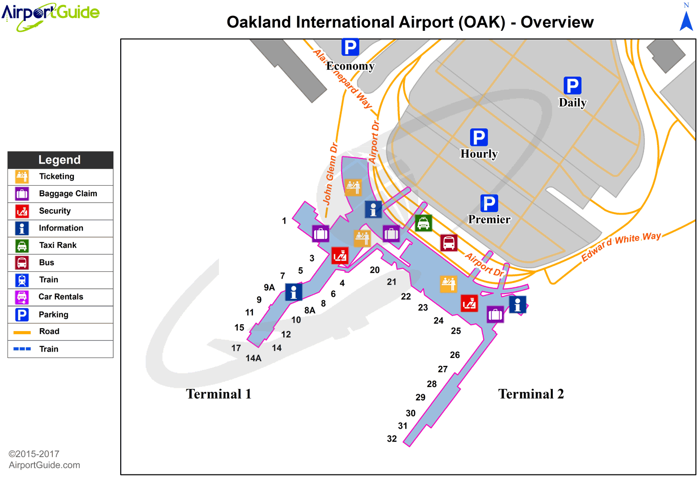
Maps & Diagrams
OAK Sectional
Flight Planning
at skyvector.com
at skyvector.com
 Diagram")