Location
Latitude: |
46-54-58.7000N (46.916306) |
Longitude: |
114-05-26.0000W (-114.090556) |
Elevation: |
3205.6 feet MSL (977 m MSL) |
Magnetic Variation: |
12.8 E (as of April 2024 from WMM2020 model) |
Time Zone: |
UTC -7.0 (Standard Time) UTC -6.0 (Daylight Savings Time) |
From City: |
04 N.M. NW of Missoula, Montana |
Found On: |
Great Falls Chart |
FAA Region: |
ANM |
Contacts
Manager: |
Publicly owned: |
| BRIAN ELLESTAD 5225 WEST BROADWAY MISSOULA, MT 59808 406-728-4381 |
MISSOULA CTY ARPT AUTH 5225 WEST BROADWAY MISSOULA, MT 59808 406-728-4381 |
Operations
Airport Status: |
Operational |
Facility Use: |
Public |
Type: |
Airport |
Activation Date: |
07/1941 |
Control tower: |
Yes |
Attendance (Months/Days/Hours): |
Months/Days/Hours ALL/ALL/ALL |
Boundary ARTCC: |
ZLC (Salt Lake City) |
Responsible ARTCC: |
ZLC (Salt Lake City) |
Lighting Schedule: |
SEE RMK |
Segmented Circle Indicator: |
Yes |
Traffic Pattern Altitude (MSL): |
4206 feet (1282 m) |
NOTAMs Facility: |
MSO |
NOTAM-D Service: |
Yes |
International Airport of Entry: |
No |
Customs Landing Rights: |
No |
Military Landing Rights: |
Yes |
Civil/Military Joint Use: |
No |
Aircraft Rescue and Firefighting: |
Class I ARFF Index: B Air Carrier Service: Scheduled Certification Date: 05/1973 |
Based Aircraft
| Single Engine: | 104 |
| Multi Engine: | 12 |
| Jet Engine: | 32 |
| GA Helicopters: | 26 |
Annual Operations (as of 12/31/2023)
| Total Operations: | 42681 | |
| Commercial: | 8653 | 20.3% |
| Air Taxi: | 5419 | 12.7% |
| GA Local: | 17423 | 40.8% |
| GA Itinerant: | 9987 | 23.4% |
| Military Aircraft: | 1199 | 2.8% |
Communications
| CTAF: | 118.400 |
| Unicom: | 122.950 |
| Tower: | MISSOULA 118.4 377.175 Hrs: 0600-2200 |
| Ground: | 121.9 |
| Approach: | SPOKANE 124.9 124.9 SALT LAKE ARTCC |
| Departure: | SPOKANE 124.9 124.9 SALT LAKE ARTCC |
| ATIS: | 126.65 Hrs: 24 |
| ASOS: | (406-728-3743) |
- APCH/DEP CTL SVC PRVDD BY SALT LAKE ARTCC (ZLC) ON FREQS 127.075/244.875 (MILLER PEAK RCAG) WHEN SPOKANE APCH CTL (GEG) IS UNAVBL 2320-0700.
- COMMUNICATIONS PRVDD BY GREAT FALLS RADIO ON FREQ 122.2 (MILLER PEAK RCO).
Fixed Based Operators (FBOs) & Fuel
(Click on a business for detail)
Please help us keep this information up to date. This is a FREE SERVICE just like everything else on Airport Guide! If you see that a business needs to be added, modified, or deleted please fill out our Update Form.
To add, modify, or delete a business click here.
Please help us keep this information up to date. This is a FREE SERVICE just like everything else on Airport Guide! If you see that a business needs to be added, modified, or deleted please fill out our Update Form.
Area Code: 406 |
| Business Name | Frequency | Phone | Fuel Grade |
|---|---|---|---|
| Aerotronics, Inc.
Update FBO info |
Unicom 122.95 | 728-7830 | |
| Minuteman Aviation, Inc.
Website Update FBO info |
Unicom 122.95 | 728-9363 | 100LL, Jet A |

|
 Exxon |
100LL - 2.58 USD per gallon on 9/28/01 |
Pumps |
|
|
Exxon |
Jet A - 2.35 USD per gallon on 9/28/01 |
Pumps |
| Northstar Air Express, Inc.
Website Update FBO info |
Unicom 123.3 | 721-8886 | 100LL, Jet A |
Flight Service Stations
| Primary | Alternate | |
| FSS on Field: | ||
| FSS Name (ID): | Great Falls(GTF) | |
| Frequency: | ||
| Toll Free Phone: | 1-800-WX-BRIEF |
Instrument Procedures / Charts
FAA Terminal Procedures valid from 0901Z 03/21/24 to 0901Z 04/18/24.
There are various types of charts available for an airport. They are listed in the Page Type column. Here is a legend for those types:
APD - Airport Diagram
DP - Departure Procedure Charts
HOT - Hot Spots
IAP - Instrument Approach Procedure Charts
MIN - Minimums
STAR - Standard Terminal Arrival Charts
| Page Type | Page Name | Volume | Action Since Last Cycle |
|---|---|---|---|
| APD | AIRPORT DIAGRAM | NW-1 | |
| DP | DIDLY FIVE | NW-1 | |
| DP | MZULA FIVE | NW-1 | |
| DP | VICTO ONE (RNAV) | NW-1 | |
| IAP | ILS Y RWY 12 | NW-1 | |
| IAP | ILS Z RWY 12 | NW-1 | |
| IAP | RNAV (GPS) Y RWY 12 | NW-1 | |
| IAP | RNAV (GPS)-D | NW-1 | |
| IAP | RNAV (RNP) RWY 30 | NW-1 | |
| IAP | RNAV (RNP) Z RWY 12 | NW-1 | |
| IAP | VOR-A | NW-1 | |
| IAP | VOR-B | NW-1 | |
| MIN | ALTERNATE MINIMUMS | NW-1 | |
| MIN | TAKEOFF MINIMUMS | NW-1 | |
| ODP | GRZLY THREE (OBSTACLE) | NW-1 |
Terminal Procedures are only available for airports in several countries with more being added all the time. If you are looking for a specific country's charts, please send an email to support(at)airportguide.com stating the country name. This will be used to prioritize the implementation.
Navigation Aids (Navaids) near MSO
| Dist (NM) | ID | Morse Code | Name | Type | Freq | True Hdg | Mag Hdg |
|---|---|---|---|---|---|---|---|
| 0.6 | MSO | _ _ . . . _ _ _ | Missoula | VOR-DME | 112.80 | 150 | 137 |
| 16.5 | INE | . . _ . . | Konna | NDB | 521 | 310 | 297 |
| 71.2 | MLP | _ _ . _ . . . _ _ . | Mullan Pass | VOR-DME | 117.80 | 297 | 284 |
| 73.1 | SAK | . . . . _ _ . _ | Smith Lake | NDB | 515 | 348 | 335 |
| 76.8 | CPN | _ . _ . . _ _ . _ . | Coppertown | VOR-DME | 116.05 | 133 | 121 |
| 77.9 | FCA | . . _ . _ . _ . . _ | Kalispell | VOR-DME | 113.20 | 357 | 344 |
| 89.8 | HLN | . . . . . _ . . _ . | Helena | VORTAC | 117.70 | 101 | 89 |
| 90.4 | CVP | _ . _ . . . . _ . _ _ . | Capitol | NDB | 335 | 101 | 89 |
| 95.1 | CII | _ . _ . . . . . | Choteau | NDB | 269 | 54 | 42 |
| 98.1 | HAU | . . . . . _ . . _ | Hauser | NDB | 386 | 101 | 89 |
Nearby Airports with Fuel
Notices to Airmen (NOTAMS)
Remarks
| A110-1 | CONTACT ARPT MANAGER TO REQUEST APPROVAL PRIOR TO ULTRALIGHT OPNS. |
| A110-11 | COLD TEMPERATURE AIRPORT. ALTITUDE CORRECTION REQUIRED AT OR BELOW -12C. |
| A110-13 | PRCHTG AT OR ARND THE ARPT. |
| A110-4 | TWY G BTN RWY 08 END TO RWY 12/30 RSTRD TO ACFT UNDER 12500 LBS. |
| A110-7 | LDG FEE FOR ALL COML ACFT AND ALL ACFT OVER 12,500 LBS. |
| A110-8 | MIGRATORY & SMALL BIRD ACTVTY ON & INVOF ARPT YEAR ROUND. |
| A110-9 | HANG GLIDER OPS, PARAGLIDER ACT 5.5 NM EAST OF AER RWY 30. |
| A30-08/26 | WHEN TWR CLSD RWY 08/26 CLSD EXC TAXI . |
| A35-12/30 | 180 DEG TURNS FOR ACFT OVR 12500 LBS GWT PROHIBITED ON ALL MOVEMENT AREAS. AVOID LOCKED TURNS AT ALL TIMES. |
| A81-APT | WHEN ATCT CLSD ACTVT MALSR RWY 12; PAPI RWY 30; MIRL 08/26; HIRL RWY 12/30 - CTAF. |
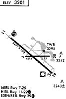
Runways
Runway Summary
| Runways: | 08/26 12/30 |
| Longest Runway: | 12/30 is 9501 ft (2896 m) long |
| Runways with an Instrument Approach: | 12 |
MSO Airport Runway Details
| Runway 08/26 | 4612 ft x 75 ft (1406 m x 23 m) | |
| Runway Length Source: | 3RD PARTY SURVEY as of 05/13/2008 | |
| Surface: | Asphalt - Fair condition - Saw-cut or plastic grooved | |
| Runway Pavement Class: | 40 /F/D/W/T | |
| Runway Edge Lights: | Medium Intensity | |
Runway Weight Bearing Capacity (in thousands of pounds) |
||
| Single Wheel Landing Gear: | 30.0 | |
| Dual Wheel Landing Gear: | 50.0 | |
Runway 08 |
Runway 26 |
|
Elevation: |
3199.2 | 3204.2 |
Latitude: |
46-54-57.6439N | 46-54-58.1689N |
Longitude: |
114-05-47.8090W | 114-04-41.3887W |
|
Runway True Alignment: |
089 | 269 |
Glide Path Angle: |
0.0 degrees | 0.0 degrees |
Traffic Pattern: |
Left | Left |
Runway Markings Type: |
Basic | Basic |
Runway Markings Condition: |
Good | Good |
Object Height: |
41 | |
Distance from End: |
1271 | |
Object Centerline Offset: |
300 ft. right of centerline | |
Declared Distances |
||
Take Off Run Avbl. (TORA): |
4612 | 4612 |
Take Off Distance Avbl. (TODA): |
4612 | 4612 |
Actual Stop Dist. Avbl. (ASDA): |
4612 | 4612 |
Landing Dist. Avbl. (LDA): |
4612 | 4612 |
| Runway 12/30 | 9501 ft x 150 ft (2896 m x 46 m) | |
| Runway Length Source: | 3RD PARTY SURVEY as of 05/13/2008 | |
| Surface: | Asphalt - Fair condition - Saw-cut or plastic grooved | |
| Runway Pavement Class: | 83 /F/D/W/T | |
| Runway Edge Lights: | High Intensity | |
Runway Weight Bearing Capacity (in thousands of pounds) |
||
| Single Wheel Landing Gear: | 145.0 | |
| Dual Wheel Landing Gear: | 170.0 | |
| Dual Tandem Wheel Landing Gear: | 255.0 | |
Runway 12 |
Runway 30 |
|
Elevation: |
3192.4 | 3205.5 |
Latitude: |
46-55-29.4399N | 46-54-28.5928N |
Longitude: |
114-06-23.6138W | 114-04-39.5045W |
|
Runway True Alignment: |
130 | 310 |
ILS Type: |
ILS | |
Glide Path Angle: |
3.0 degrees | 3.0 degrees |
Traffic Pattern: |
Left | Left |
Runway Markings Type: |
Precision Instrument | Nonprecision Instrument |
Runway Markings Condition: |
Good | Good |
Object Centerline Offset: |
300 ft. right of centerline | |
Visual Glide Slope Indicators: |
4-Light PAPI On Left Side Of Runway | 4-Light PAPI On Left Side Of Runway |
Runway Visual Range (RVR): |
Touchdown | Rollout |
Approach Light System: |
1,400 Foot Medium Intensity Approach Lighting System With Runway Alignment Indicator Lights | |
REIL: |
No | Yes |
Threshold Crossing Height: |
55 | 50 |
Declared Distances |
||
Take Off Run Avbl. (TORA): |
9501 | 9501 |
Take Off Distance Avbl. (TODA): |
9501 | 9501 |
Actual Stop Dist. Avbl. (ASDA): |
9501 | 9501 |
Landing Dist. Avbl. (LDA): |
9501 | 9501 |
Services
Airframe Repair: |
None |
Powerplant Repair: |
None |
Bottled Oxygen: |
None |
Bulk Oxygen: |
None |
Fuel Available: |
100LL, Jet A |
Landing Fees: |
No |
Parking: |
Tiedowns available |
Maps & Diagrams
MSO Sectional
Flight Planning
at skyvector.com
at skyvector.com