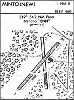
Location
Latitude: |
65-08-53.4000N (65.148167) |
Longitude: |
149-22-06.9000W (-149.368583) |
Elevation: |
499.8 feet MSL (152 m MSL) |
Magnetic Variation: |
15.1 E (as of April 2024 from WMM2020 model) |
Time Zone: |
UTC -9.0 (Standard Time) UTC -8.0 (Daylight Savings Time) |
From City: |
01 N.M. E of Minto, Alaska |
Found On: |
Fairbanks Chart |
FAA Region: |
AAL |
Contacts
Manager: |
Publicly owned: |
| JEFF RUSSELL 2301 PEGER ROAD FAIRBANKS, AK 99709 907-451-2207 |
ALASKA DOT&PF NORTHERN REGION 2301 PEGER ROAD FAIRBANKS, AK 99709 907-451-2200 |
Operations
Airport Status: |
Operational |
Facility Use: |
Public |
Type: |
Airport |
Activation Date: |
07/1975 |
Control tower: |
No |
Attendance (Months/Days/Hours): |
Months/Days/Hours Unattended |
Boundary ARTCC: |
ZAN (Anchorage) |
Responsible ARTCC: |
ZAN (Anchorage) |
Lighting Schedule: |
SEE RMK |
Segmented Circle Indicator: |
Yes |
Traffic Pattern Altitude (MSL): |
1500 feet (457 m) |
NOTAMs Facility: |
FAI |
NOTAM-D Service: |
Yes |
International Airport of Entry: |
No |
Customs Landing Rights: |
No |
Military Landing Rights: |
Yes |
Based Aircraft
Annual Operations (as of 12/31/2022)
| Total Operations: | 1000 | |
| Air Taxi: | 500 | 50.0% |
| GA Itinerant: | 500 | 50.0% |
Communications
| CTAF: | 122.900 |
Fixed Based Operators (FBOs) & Fuel
(Click on a business for detail)
Please help us keep this information up to date. This is a FREE SERVICE just like everything else on Airport Guide! If you see that a business needs to be added, modified, or deleted please fill out our Update Form.
To add, modify, or delete a business click here.
Please help us keep this information up to date. This is a FREE SERVICE just like everything else on Airport Guide! If you see that a business needs to be added, modified, or deleted please fill out our Update Form.
Area Code: 907 |
| Business Name | Frequency | Phone | Fuel Grade |
|---|
Flight Service Stations
| Primary | Alternate | |
| FSS on Field: | ||
| FSS Name (ID): | Fairbanks(FAI) | |
| Frequency: | ||
| Toll Free Phone: | 1-866-248-6516 |
Instrument Procedures / Charts
Terminal Procedures are only available for airports in several countries with more being added all the time. If you are looking for a specific country's charts, please send an email to support(at)airportguide.com stating the country name. This will be used to prioritize the implementation.
Navigation Aids (Navaids) near MNT
| Dist (NM) | ID | Morse Code | Name | Type | Freq | True Hdg | Mag Hdg |
|---|---|---|---|---|---|---|---|
| 34.3 | ENN | . _ . _ . | Nenana | VORTAC | 115.80 | 167 | 152 |
| 36.9 | ICW | . . _ . _ . . _ _ | Ice Pool | NDB | 525 | 168 | 153 |
| 40.3 | FAI | . . _ . . _ . . | Fairbanks | VORTAC | 108.60 | 120 | 105 |
| 46.5 | FOX | . . _ . _ _ _ _ . . _ | Fox | NDB | 356 | 102 | 87 |
| 51.0 | CUN | _ . _ . . . _ _ . | Chena | NDB | 257 | 110 | 95 |
| 65.0 | EIL | . . . . _ . . | Eielson | TACAN | 115.10 | 116 | 101 |
| 70.8 | TAL | _ . _ . _ . . | Tanana | VOR-DME | 116.60 | 272 | 257 |
| 71.5 | BCC | _ . . . _ . _ . _ . _ . | Bear Creek | NDB | 212 | 272 | 258 |
Nearby Airports with Fuel
| Dist (NM) | Name (Airport IDs) | True Hdg | Mag Hdg | Fuel Grade |
|---|---|---|---|---|
| 36.8 | Nenana Municipal Airport (ENN PANN ENN) |
168 | 153 | 100LL, Jet A |
| 43.2 | Fairbanks International Airport (FAI PAFA FAI) |
116 | 100 | 100LL, Jet A-1 |
| 55.5 | Bradley Sky-Ranch Airport (95Z) |
113 | 97 | 100LL |
Notices to Airmen (NOTAMS)
Remarks
| A110-1 | BE ALERT: WINDS ARE ERRATIC AT THIS ARPT. |
| A110-2 | RY CONDITION NOT MONITORED; RECOMMEND VISUAL INSPECTION PRIOR TO LANDING. |
| A110-3 | SNOW REMOVAL OPNS DURING WINTER MONITOR - CTAF. |
| A110-4 | WX CAMERA AVBL ON INTERNET AT HTTPS://WEATHERCAMS.FAA.GOV |
| A110-5 | BE ALERT: WATERFOWL INVOF RY APCHS. |
| A81-APT | ACTVT MIRL RY 02/20; PAPI & REIL RYS 02 & 20 - CTAF. |
| A81-BCN | ACTVT ROTG BCN- CTAF. |
Runways
Runway Summary
| Runways: | 02/20 |
| Longest Runway: | 02/20 is 3400 ft (1036 m) long |
| Runways with an Instrument Approach: |
MNT Airport Runway Details
| Runway 02/20 | 3400 ft x 75 ft (1036 m x 23 m) | |
| Runway Length Source: | 3RD PARTY SURVEY as of 07/08/2010 | |
| Surface: | Gravel - Good condition - No special surface treatment | |
| Runway Edge Lights: | Medium Intensity | |
Runway 02 |
Runway 20 |
|
Elevation: |
499.8 | 472.6 |
Latitude: |
65-08-41.0054N | 65-09-05.8226N |
Longitude: |
149-22-33.5873W | 149-21-40.2534W |
|
Runway True Alignment: |
042 | 222 |
Glide Path Angle: |
3.0 degrees | 3.0 degrees |
Traffic Pattern: |
Left | Left |
Visual Glide Slope Indicators: |
4-Light PAPI On Left Side Of Runway | 4-Light PAPI On Left Side Of Runway |
REIL: |
Yes | Yes |
Touchdown Lights: |
Yes | Yes |
Threshold Crossing Height: |
26 | 26 |
Services
Airframe Repair: |
None |
Powerplant Repair: |
None |
Bottled Oxygen: |
None |
Bulk Oxygen: |
None |
Fuel Available: |
100LL |
Landing Fees: |
No |
Parking: |
Tiedowns available |
Maps & Diagrams
MNT Sectional
Flight Planning
at skyvector.com
at skyvector.com