Location
Latitude: |
38-45-35.7000N (38.759917) |
Longitude: |
085-27-52.9000W (-85.464694) |
Elevation: |
819.1 feet MSL (250 m MSL) |
Magnetic Variation: |
5.4 W (as of April 2024 from WMM2020 model) |
Time Zone: |
UTC -5.0 (Standard Time) UTC -4.0 (Daylight Savings Time) |
From City: |
04 N.M. W of Madison, Indiana |
Found On: |
St Louis Chart |
FAA Region: |
AGL |
Contacts
Manager: |
Publicly owned: |
| BRENT SPRY 3919 W. IMS LANE MADISON, IN 47250 812-273-1914 |
MADISON BOAC 101 W. MAIN ST. MADISON, IN 47250 812-265-8316 |
Operations
Airport Status: |
Operational |
Facility Use: |
Public |
Type: |
Airport |
Activation Date: |
05/1964 |
Control tower: |
No |
Attendance (Months/Days/Hours): |
Months/Days/Hours MAR-OCT/ALL/0800-1730 |
Boundary ARTCC: |
ZID (Indianapolis) |
Responsible ARTCC: |
ZID (Indianapolis) |
Lighting Schedule: |
SEE RMK |
Segmented Circle Indicator: |
No |
Traffic Pattern Altitude (MSL): |
1819 feet (554 m) |
NOTAMs Facility: |
HUF |
NOTAM-D Service: |
Yes |
International Airport of Entry: |
No |
Customs Landing Rights: |
No |
Military Landing Rights: |
Yes |
Civil/Military Joint Use: |
No |
Based Aircraft
| Single Engine: | 47 |
| Multi Engine: | 3 |
| Jet Engine: | 4 |
| GA Helicopters: | 1 |
Annual Operations (as of 12/31/2019)
| Total Operations: | 15650 | |
| Air Taxi: | 1250 | 8.0% |
| GA Local: | 9547 | 61.0% |
| GA Itinerant: | 3913 | 25.0% |
| Military Aircraft: | 940 | 6.0% |
Communications
| CTAF: | 123.000 |
| Unicom: | 123.000 |
| Approach: | LOUISVILLE 132.075 132.075 |
| Departure: | LOUISVILLE 132.075 132.075 |
| AWOS-3: | 119.175 (812-866-1798) |
Fixed Based Operators (FBOs) & Fuel
(Click on a business for detail)
Please help us keep this information up to date. This is a FREE SERVICE just like everything else on Airport Guide! If you see that a business needs to be added, modified, or deleted please fill out our Update Form.
To add, modify, or delete a business click here.
Please help us keep this information up to date. This is a FREE SERVICE just like everything else on Airport Guide! If you see that a business needs to be added, modified, or deleted please fill out our Update Form.
Area Code: 812 |
| Business Name | Frequency | Phone | Fuel Grade |
|---|---|---|---|
| HFG-DBA Rogers Aviation
Update FBO info |
Unicom 122.8 | 265-4599 | 100LL, Jet A |
Flight Service Stations
| Primary | Alternate | |
| FSS on Field: | N | |
| FSS Name (ID): | Terre Haute(HUF) | |
| Frequency: | ||
| Toll Free Phone: | 1-800-WX-BRIEF |
Instrument Procedures / Charts
FAA Terminal Procedures valid from 0901Z 03/21/24 to 0901Z 04/18/24.
There are various types of charts available for an airport. They are listed in the Page Type column. Here is a legend for those types:
APD - Airport Diagram
DP - Departure Procedure Charts
HOT - Hot Spots
IAP - Instrument Approach Procedure Charts
MIN - Minimums
STAR - Standard Terminal Arrival Charts
| Page Type | Page Name | Volume | Action Since Last Cycle |
|---|---|---|---|
| IAP | RNAV (GPS) RWY 21 | EC-2 | |
| IAP | RNAV (GPS) Y RWY 03 | EC-2 | |
| IAP | RNAV (GPS) Z RWY 03 | EC-2 | |
| MIN | ALTERNATE MINIMUMS | EC-2 | |
| MIN | TAKEOFF MINIMUMS | EC-2 |
Terminal Procedures are only available for airports in several countries with more being added all the time. If you are looking for a specific country's charts, please send an email to support(at)airportguide.com stating the country name. This will be used to prioritize the implementation.
Navigation Aids (Navaids) near MDN
| Dist (NM) | ID | Morse Code | Name | Type | Freq | True Hdg | Mag Hdg |
|---|---|---|---|---|---|---|---|
| 0.3 | GVR | _ _ . . . . _ . _ . | Hanover | DME | 114.65 | 250 | 255 |
| 13.0 | ABB | . _ _ . . . _ . . . | Nabb | VORTAC | 112.40 | 218 | 223 |
| 21.4 | JV | . _ _ _ . . . _ | Catch | NDB | 331 | 216 | 221 |
| 24.6 | EQZ | . _ _ . _ _ _ . . | Captain | NDB | 308 | 285 | 290 |
| 33.1 | BQM | _ . . . _ _ . _ _ _ | Bowman | DME | 112.2 | 196 | 201 |
| 36.5 | HLB | . . . . . _ . . _ . . . | Batesville | NDB | 254 | 15 | 21 |
| 36.6 | UR | . . _ . _ . | Burln | NDB | 321 | 61 | 67 |
| 36.6 | SDF | . . . _ . . . . _ . | Louisville Standifd | VOT | 111.00 | 200 | 205 |
| 37.5 | BA | _ . . . . _ | Clifs | NDB | 410 | 334 | 339 |
| 37.7 | LK | . _ . . _ . _ | Laang | NDB | 414 | 192 | 197 |
| 38.7 | CVG | _ . _ . . . . _ _ _ . | Cincinnati | VORTAC | 117.30 | 66 | 72 |
| 39.7 | IIU | . . . . . . _ | Louisville | VORTAC | 114.80 | 187 | 192 |
| 43.4 | FFT | . . _ . . . _ . _ | Frankfort | VOR | 109.40 | 142 | 148 |
| 45.7 | BFR | _ . . . . . _ . . _ . | Bedford | NDB | 344 | 276 | 281 |
| 52.9 | LUK | . _ . . . . _ _ . _ | Cincinnati Muni/Lunken | VOT | 108.40 | 66 | 72 |
| 53.8 | GOI | _ _ . _ _ _ . . | Godman | NDB | 396 | 206 | 211 |
| 54.4 | FLM | . . _ . . _ . . _ _ | Falmouth | VOR-DME | 117.00 | 96 | 102 |
| 54.7 | BRY | _ . . . . _ . _ . _ _ | Bardstown/Dcmsnd | NDB | 248 | 180 | 185 |
| 55.0 | SHB | . . . . . . . _ . . . | Shelbyville | VOR-DME | 116.15 | 342 | 347 |
| 55.0 | OXD | _ _ _ _ . . _ _ . . | Oxford | NDB | 282 | 35 | 41 |
Nearby Airports with Fuel
Notices to Airmen (NOTAMS)
Remarks
| A110*G | THIS AIRPORT HAS BEEN SURVEYED BY THE NATIONAL GEODETIC SURVEY. |
| A110-1 | FOR CD CTC LOUISVILLE APCH AT 502-375-7499 |
| A17 | UNATNDD THANKSGIVING, CHRISTMAS & NEW YEARS. |
| A70-FUEL-10 | 0LL SELF SERVE AVBL. |
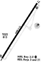
| A81-APT | ACTVT MALSF RWY 03; REIL RWY 21; PAPI RWY 03 & 21; HIRL RWY 03/21 - CTAF. |
Runways
Runway Summary
| Runways: | 03/21 |
| Longest Runway: | 03/21 is 5000 ft (1524 m) long |
| Runways with an Instrument Approach: |
MDN Airport Runway Details
| Runway 03/21 | 5000 ft x 75 ft (1524 m x 23 m) | |
| Runway Length Source: | NGS as of 08/03/2007 | |
| Surface: | Asphalt - Good condition - Saw-cut or plastic grooved | |
| Runway Pavement Class: | 23 /F/C/X/T | |
| Runway Edge Lights: | High Intensity | |
Runway Weight Bearing Capacity (in thousands of pounds) |
||
| Single Wheel Landing Gear: | 61.0 | |
| Dual Wheel Landing Gear: | 82.0 | |
Runway 03 |
Runway 21 |
|
Elevation: |
807.2 | 819.1 |
Latitude: |
38-45-14.6430N | 38-45-56.6668N |
Longitude: |
085-28-09.5192W | 085-27-36.2950W |
|
Runway True Alignment: |
032 | 212 |
Glide Path Angle: |
3.5 degrees | 3.0 degrees |
Traffic Pattern: |
Left | Left |
Runway Markings Type: |
Nonprecision Instrument | Nonprecision Instrument |
Runway Markings Condition: |
Good | Good |
Object at End: |
TREES | CROPS |
Object Height: |
80 | 10 |
Object Marked/Lighted?: |
Lighted | |
Distance from End: |
1850 | 201 |
Object Centerline Offset: |
435 ft. right of centerline | 0 ft. left and right of centerline |
Visual Glide Slope Indicators: |
4-Light PAPI On Left Side Of Runway | 2-Light PAPI On Left Side Of Runway |
Approach Light System: |
1,400 Foot Medium Intensity Approach Lighting System With Sequenced Flashers | |
REIL: |
No | Yes |
Touchdown Lights: |
No | No |
Centerline Lights: |
No | No |
Threshold Crossing Height: |
42 | 39 |
Services
Bottled Oxygen: |
None |
Bulk Oxygen: |
None |
Fuel Available: |
100LL, Jet A |
Landing Fees: |
No |
Parking: |
Hangars and tiedowns available |
Maps & Diagrams
MDN Sectional
Flight Planning
at skyvector.com
at skyvector.com