Location
Latitude: |
36-07-40.6440N (36.127957) |
Longitude: |
087-25-47.4230W (-87.42984) |
Elevation: |
892.1 feet MSL (272 m MSL) |
Magnetic Variation: |
3.7 W (as of April 2024 from WMM2020 model) |
Time Zone: |
UTC -6.0 (Standard Time) UTC -5.0 (Daylight Savings Time) |
From City: |
03 N.M. N of Dickson, Tennessee |
Found On: |
St Louis Chart |
FAA Region: |
ASO |
Contacts
Manager: |
Publicly owned: |
| MIKE GALLAGHER 2372 SYLVIA RD DICKSON, TN 37056 (615) 812-1981 |
DICKSON COUNTY ARPT AUTHORITY P.O.BOX 901 DICKSON, TN 37056 615-446-6611 |
Operations
Airport Status: |
Operational |
Facility Use: |
Public |
Type: |
Airport |
Control tower: |
No |
Attendance (Months/Days/Hours): |
Months/Days/Hours ALL/ALL/0800-1800 |
Boundary ARTCC: |
ZME (Memphis) |
Responsible ARTCC: |
ZME (Memphis) |
Lighting Schedule: |
SS-SR |
Segmented Circle Indicator: |
Yes |
Traffic Pattern Altitude (MSL): |
1892 feet (577 m) |
NOTAMs Facility: |
MKL |
NOTAM-D Service: |
Yes |
International Airport of Entry: |
No |
Customs Landing Rights: |
No |
Military Landing Rights: |
Yes |
Civil/Military Joint Use: |
No |
Based Aircraft
| Single Engine: | 25 |
| Multi Engine: | 4 |
| Jet Engine: | 1 |
| GA Helicopters: | 1 |
Annual Operations (as of 12/31/2017)
| Total Operations: | 12984 | |
| Air Taxi: | 240 | 1.8% |
| GA Local: | 5256 | 40.5% |
| GA Itinerant: | 7200 | 55.5% |
| Military Aircraft: | 288 | 2.2% |
Communications
| CTAF: | 122.800 |
| Unicom: | 122.800 |
| AWOS-3: | 123.875 (615-446-5481) |
- APCH/DEP SVC PRVDD BY MEMPHIS ARTCC ON FREQS 125.85/379.25 (CENTERVILLE RCAG).
Fixed Based Operators (FBOs) & Fuel
(Click on a business for detail)
Please help us keep this information up to date. This is a FREE SERVICE just like everything else on Airport Guide! If you see that a business needs to be added, modified, or deleted please fill out our Update Form.
To add, modify, or delete a business click here.
Please help us keep this information up to date. This is a FREE SERVICE just like everything else on Airport Guide! If you see that a business needs to be added, modified, or deleted please fill out our Update Form.
Area Code: 615 |
| Business Name | Frequency | Phone | Fuel Grade |
|---|---|---|---|
| Dickson Air Center LLC
Update FBO info |
Unicom 122.8 | 446-5962 |
Flight Service Stations
| Primary | Alternate | |
| FSS on Field: | N | |
| FSS Name (ID): | Jackson(MKL) | |
| Frequency: | ||
| Toll Free Phone: | 1-800-WX-BRIEF |
Instrument Procedures / Charts
FAA Terminal Procedures valid from 0901Z 03/21/24 to 0901Z 04/18/24.
There are various types of charts available for an airport. They are listed in the Page Type column. Here is a legend for those types:
APD - Airport Diagram
DP - Departure Procedure Charts
HOT - Hot Spots
IAP - Instrument Approach Procedure Charts
MIN - Minimums
STAR - Standard Terminal Arrival Charts
| Page Type | Page Name | Volume | Action Since Last Cycle |
|---|---|---|---|
| IAP | RNAV (GPS) RWY 17 | SE-1 | |
| MIN | TAKEOFF MINIMUMS | SE-1 |
Terminal Procedures are only available for airports in several countries with more being added all the time. If you are looking for a specific country's charts, please send an email to support(at)airportguide.com stating the country name. This will be used to prioritize the implementation.
Navigation Aids (Navaids) near M02
| Dist (NM) | ID | Morse Code | Name | Type | Freq | True Hdg | Mag Hdg |
|---|---|---|---|---|---|---|---|
| 0.1 | DMZ | _ . . _ _ _ _ . . | Dickson | NDB | 203 | 252 | 256 |
| 15.1 | AEY | . _ . _ . _ _ | Waverly | NDB | 329 | 267 | 271 |
| 17.7 | GHM | _ _ . . . . . _ _ | Graham | DME | 111.6 | 183 | 187 |
| 24.0 | CK | _ . _ . _ . _ | Snuff | NDB | 335 | 4 | 8 |
| 29.4 | ON | _ _ _ _ . | Music | NDB | 279 | 47 | 51 |
| 29.7 | CKV | _ . _ . _ . _ . . . _ | Clarksville | VOR-DME | 110.60 | 1 | 5 |
| 32.1 | HXW | . . . . _ . . _ . _ _ | Screaming Eagle | TACAN | 114.90 | 353 | 357 |
| 35.3 | PBC | . _ _ . _ . . . _ . _ . | Maury County | NDB | 365 | 152 | 156 |
| 36.1 | BNA | _ . . . _ . . _ | Nashville | VORTAC | 114.10 | 88 | 92 |
| 36.6 | FK | . . _ . _ . _ | Airbe | NDB | 273 | 1 | 5 |
| 37.3 | BNA | _ . . . _ . . _ | Nashville Metropoln | VOT | 108.60 | 90 | 94 |
| 37.9 | VI | . . . _ . . | Opery | NDB | 344 | 82 | 86 |
| 41.1 | JHG | . _ _ _ . . . . _ _ . | Hohenwald | NDB | 257 | 193 | 197 |
| 45.3 | MQY | _ _ _ _ . _ _ . _ _ | Smyrna | VOT | 110.20 | 98 | 102 |
| 45.4 | HIX | . . . . . . _ . . _ | Honey Grove | NDB | 356 | 5 | 9 |
| 48.0 | SWZ | . . . . _ _ _ _ . . | Sewart | NDB | 391 | 102 | 106 |
| 48.2 | LUG | . _ . . . . _ _ _ . | Verona | NDB | 251 | 141 | 145 |
| 48.3 | TIQ | _ . . _ _ . _ | Trainer | NDB | 410 | 278 | 281 |
| 50.3 | HZD | . . . . _ _ . . _ . . | Huntingdon | NDB | 217 | 267 | 270 |
| 52.3 | FQW | . . _ . _ _ . _ . _ _ | Walter Hill | NDB | 371 | 100 | 104 |
Nearby Airports with Fuel
Notices to Airmen (NOTAMS)
Remarks
| A110-1 | FOR CD CTC MEMPHIS ARTCC AT 901-368-8453/8449. |
| A17 | AFT HR - AMGR. |
Runways
Runway Summary
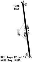
| Runways: | 17/35 |
| Longest Runway: | 17/35 is 5001 ft (1524 m) long |
| Runways with an Instrument Approach: |
M02 Airport Runway Details
| Runway 17/35 | 5001 ft x 75 ft (1524 m x 23 m) | |
| Runway Length Source: | 3RD PARTY SURVEY as of 12/05/2016 | |
| Surface: | Asphalt - Good condition - No special surface treatment | |
| Runway Pavement Class: | 17 /F/C/X/T | |
| Runway Edge Lights: | Medium Intensity | |
Runway Weight Bearing Capacity (in thousands of pounds) |
||
| Single Wheel Landing Gear: | 16.0 | |
| Dual Wheel Landing Gear: | 26.0 | |
Runway 17 |
Runway 35 |
|
Elevation: |
892.1 | 868.0 |
Latitude: |
36-08-05.1393N | 36-07-16.1492N |
Longitude: |
087-25-51.5762W | 087-25-43.2701W |
|
Runway True Alignment: |
172 | 352 |
Glide Path Angle: |
0.0 degrees | 0.0 degrees |
Traffic Pattern: |
Left | Left |
Runway Markings Type: |
Nonprecision Instrument | Nonprecision Instrument |
Runway Markings Condition: |
Good | Good |
Object at End: |
TREES | TREES |
Object Height: |
62 | 74 |
Distance from End: |
1469 | 1332 |
Object Centerline Offset: |
312 ft. right of centerline | 308 ft. left of centerline |
REIL: |
Yes | Yes |
Services
Airframe Repair: |
Minor |
Powerplant Repair: |
Major |
Bottled Oxygen: |
Low Pressure |
Fuel Available: |
100LL, Jet A+ |
Landing Fees: |
No |
Parking: |
Hangars and tiedowns available |
Maps & Diagrams
M02 Sectional
Flight Planning
at skyvector.com
at skyvector.com