Location
Latitude: |
36-52-42.3230N (36.878423) |
Longitude: |
091-54-09.6280W (-91.902674) |
Elevation: |
1228.3 feet MSL (374 m MSL) |
Magnetic Variation: |
0.6 W (as of April 2024 from WMM2020 model) |
Time Zone: |
UTC -6.0 (Standard Time) UTC -5.0 (Daylight Savings Time) |
From City: |
10 N.M. NW of West Plains, Missouri |
Found On: |
Kansas City Chart |
FAA Region: |
ACE |
Contacts
Manager: |
Publicly owned: |
| BRIAN MITCHELL 4523 CO ROAD 2340 POMONA, MO 65789 417 372-3997 |
CITY OF WEST PLAINS 1910 HOLIDAY LANE-BOX 710 WEST PLAINS, MO 65775 417-256-7176 |
Operations
Airport Status: |
Operational |
Facility Use: |
Public |
Type: |
Airport |
Activation Date: |
05/1985 |
Control tower: |
No |
Attendance (Months/Days/Hours): |
Months/Days/Hours ALL/ALL/0800-1700 |
Boundary ARTCC: |
ZME (Memphis) |
Responsible ARTCC: |
ZME (Memphis) |
Lighting Schedule: |
SEE RMK |
Segmented Circle Indicator: |
Yes |
Traffic Pattern Altitude (MSL): |
2228 feet (679 m) |
NOTAMs Facility: |
UNO |
NOTAM-D Service: |
Yes |
Military Landing Rights: |
Yes |
Based Aircraft
| Single Engine: | 26 |
Annual Operations (as of 12/31/2019)
| Total Operations: | 2772 | |
| Air Taxi: | 250 | 9.0% |
| GA Local: | 1126 | 40.6% |
| GA Itinerant: | 1376 | 49.6% |
| Military Aircraft: | 20 | 0.7% |
Communications
| CTAF: | 122.800 |
| Unicom: | 122.800 |
| ASOS: | 123.825 (417-257-1313) |
- APCH/DEP SVC PRVDD BY MEMPHIS ARTCC ON FREQS 120.075/289.4 (WALNUT RIDGE RCAG).
Fixed Based Operators (FBOs) & Fuel
(Click on a business for detail)
Please help us keep this information up to date. This is a FREE SERVICE just like everything else on Airport Guide! If you see that a business needs to be added, modified, or deleted please fill out our Update Form.
To add, modify, or delete a business click here.
Please help us keep this information up to date. This is a FREE SERVICE just like everything else on Airport Guide! If you see that a business needs to be added, modified, or deleted please fill out our Update Form.
Area Code: 417 |
| Business Name | Frequency | Phone | Fuel Grade |
|---|---|---|---|
| Air Evac Maintenance
Update FBO info |
257-1529, 256-0010, 257-0939 | 100LL, Jet A | |
| West Plains Municipal
Update FBO info |
Unicom 122.8 | 257-1530, 257-7658 | 100LL, Jet A |
Flight Service Stations
| Primary | Alternate | |
| FSS on Field: | ||
| FSS Name (ID): | Columbia(COU) | |
| Frequency: | ||
| Toll Free Phone: | 1-800-WX-BRIEF |
Instrument Procedures / Charts
FAA Terminal Procedures valid from 0901Z 03/21/24 to 0901Z 04/18/24.
There are various types of charts available for an airport. They are listed in the Page Type column. Here is a legend for those types:
APD - Airport Diagram
DP - Departure Procedure Charts
HOT - Hot Spots
IAP - Instrument Approach Procedure Charts
MIN - Minimums
STAR - Standard Terminal Arrival Charts
| Page Type | Page Name | Volume | Action Since Last Cycle |
|---|---|---|---|
| IAP | RNAV (GPS) RWY 18 | NC-3 | |
| IAP | RNAV (GPS) RWY 36 | NC-3 | |
| MIN | ALTERNATE MINIMUMS | NC-3 | |
| MIN | TAKEOFF MINIMUMS | NC-3 |
Terminal Procedures are only available for airports in several countries with more being added all the time. If you are looking for a specific country's charts, please send an email to support(at)airportguide.com stating the country name. This will be used to prioritize the implementation.
Navigation Aids (Navaids) near KUNO
| Dist (NM) | ID | Morse Code | Name | Type | Freq | True Hdg | Mag Hdg |
|---|---|---|---|---|---|---|---|
| 0.1 | UNO | . . _ _ . _ _ _ | Pomona | NDB | 335 | 107 | 108 |
| 0.4 | HUW | . . . . . . _ . _ _ | Hutton | DME | 111.6 | 163 | 164 |
| 11.5 | MNF | _ _ _ . . . _ . | Mountain View | NDB | 365 | 52 | 53 |
| 43.1 | MAP | _ _ . _ . _ _ . | Maples | TACAN | 113.40 | 7 | 8 |
| 43.9 | FLP | . . _ . . _ . . . _ _ . | Flippin | DME | 116.05 | 217 | 217 |
| 47.5 | DGD | _ . . _ _ . _ . . | Dogwood | VORTAC | 109.40 | 280 | 280 |
| 50.1 | BHN | _ . . . . . . . _ . | Buckhorn | NDB | 391 | 349 | 350 |
| 53.1 | TBN | _ _ . . . _ . | Forney | VOR | 110.00 | 347 | 348 |
| 55.0 | IEB | . . . _ . . . | Lebanon | NDB | 414 | 319 | 319 |
| 62.1 | TNZ | _ _ . _ _ . . | Lawrence County | NDB | 227 | 130 | 131 |
| 65.0 | ARG | . _ . _ . _ _ . | Walnut Ridge | VORTAC | 114.50 | 134 | 135 |
| 70.7 | BV | _ . . . . . . _ | Almnd | NDB | 335 | 175 | 176 |
| 71.5 | HRO | . . . . . _ . _ _ _ | Harrison | VOR-DME | 112.50 | 242 | 242 |
| 73.3 | HR | . . . . . _ . | Bakky | NDB | 395 | 236 | 236 |
| 74.2 | SGF | . . . _ _ . . . _ . | Springfield | VORTAC | 116.90 | 293 | 293 |
| 76.7 | FD | . . _ . _ . . | Earli | NDB | 278 | 98 | 99 |
| 77.1 | VIH | . . . _ . . . . . . | Vichy | VOR-DME | 117.70 | 6 | 7 |
| 77.3 | SHY | . . . . . . . _ . _ _ | Sunshine | VOR-DME | 108.40 | 334 | 334 |
| 79.4 | AIZ | . _ . . _ _ . . | Kaiser | NDB | 377 | 337 | 337 |
| 87.5 | JBR | . _ _ _ _ . . . . _ . | Jonesboro | VOR-DME | 115.85 | 133 | 134 |
Nearby Airports with Fuel
Notices to Airmen (NOTAMS)
Remarks
| A110-1 | HELICOPTER OPS ON & INVOF ARPT. |
| A110-2 | FOR CD CTC MEMPHIS ARTCC AT 901-368-8453/8449. |
| A16 | 417-256-2244 AFTER HOURS PHONE |
| A17 | FOR ATTENDANT AFTER 1700 CALL 417-257-1539 OR 417-274-4043. |
| A80 | BCN LOCATED ON WATER TWR WEST OF ARPT. |
| A81-APT | ACTVT MIRL RY 18/36; PAPI RYS 18; 36 & REIL RYS 18 & 36 AFT 2200 - CTAF. |
| A96 | ULTRALIGHTS ON & INVOF APRT. |
Runways
Runway Summary
| Runways: | 18/36 |
| Longest Runway: | 18/36 is 5101 ft (1555 m) long |
| Runways with an Instrument Approach: |
KUNO Airport Runway Details
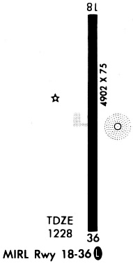
| Runway 18/36 | 5101 ft x 75 ft (1555 m x 23 m) | |
| Runway Length Source: | 3RD PARTY SURVEY as of 09/27/2010 | |
| Surface: | Asphalt - Good condition - No special surface treatment | |
| Runway Edge Lights: | Medium Intensity | |
Runway Weight Bearing Capacity (in thousands of pounds) |
||
| Single Wheel Landing Gear: | 30.0 | |
| Dual Wheel Landing Gear: | 39.0 | |
Runway 18 |
Runway 36 |
|
Elevation: |
1225.2 | 1228.2 |
Latitude: |
36-53-07.5371N | 36-52-17.1082N |
Longitude: |
091-54-09.1333W | 091-54-10.1233W |
|
Runway True Alignment: |
181 | 001 |
Glide Path Angle: |
3.0 degrees | 3.0 degrees |
Runway Markings Type: |
Nonprecision Instrument | Nonprecision Instrument |
Runway Markings Condition: |
Good | Good |
Visual Glide Slope Indicators: |
2-Light PAPI On Left Side Of Runway | 2-Light PAPI On Left Side Of Runway |
REIL: |
Yes | Yes |
Threshold Crossing Height: |
37 | 37 |
Services
Airframe Repair: |
Major |
Powerplant Repair: |
Major |
Bottled Oxygen: |
High Pressure / Low Pressure |
Bulk Oxygen: |
None |
Fuel Available: |
100LL, Jet A |
Landing Fees: |
No |
Parking: |
Hangars and tiedowns available |
Maps & Diagrams
KUNO Sectional
Flight Planning
at skyvector.com
at skyvector.com