Location
Latitude: |
41-44-34.2000N (41.742833) |
Longitude: |
089-40-34.6000W (-89.676278) |
Elevation: |
647.6 feet MSL (197 m MSL) |
Magnetic Variation: |
2.6 W (as of April 2024 from WMM2020 model) |
Time Zone: |
UTC -6.0 (Standard Time) UTC -5.0 (Daylight Savings Time) |
From City: |
02 N.M. S of Sterling/Rockfalls, Illinois |
Found On: |
Chicago Chart |
FAA Region: |
AGL |
Contacts
Manager: |
Publicly owned: |
| DARIN HEFFELFINGER 10950 HOOVER RD ROCKFALLS, IL 61071 (815) 213-7939 |
WHITESIDE COUNTY WHITESIDE COUNTY COURTHOUSE, 200 EAST KNOX STREET MORRISON, IL 61270 (815) 213-7939 |
Operations
Airport Status: |
Operational |
Facility Use: |
Public |
Type: |
Airport |
Activation Date: |
03/1948 |
Control tower: |
No |
Attendance (Months/Days/Hours): |
Months/Days/Hours ALL/ALL/0800-1700 |
Boundary ARTCC: |
ZAU (Chicago) |
Responsible ARTCC: |
ZAU (Chicago) |
Lighting Schedule: |
SEE RMK |
Segmented Circle Indicator: |
Yes |
Traffic Pattern Altitude (MSL): |
1648 feet (502 m) |
NOTAMs Facility: |
SQI |
NOTAM-D Service: |
Yes |
International Airport of Entry: |
No |
Customs Landing Rights: |
No |
Military Landing Rights: |
Yes |
Civil/Military Joint Use: |
No |
Based Aircraft
| Single Engine: | 38 |
| Multi Engine: | 1 |
Annual Operations (as of 03/31/2021)
| Total Operations: | 32720 | |
| Air Taxi: | 600 | 1.8% |
| GA Local: | 22500 | 68.8% |
| GA Itinerant: | 9500 | 29.0% |
| Military Aircraft: | 120 | 0.4% |
Communications
| CTAF: | 123.000 |
| Unicom: | 123.000 |
| Approach: | ROCKFORD 126.0 126.0 126.0 |
| Departure: | ROCKFORD 126.0 126.0 126.0 |
| AWOS-3PT: | 119.175 (815-626-2704) |
Fixed Based Operators (FBOs) & Fuel
(Click on a business for detail)
Please help us keep this information up to date. This is a FREE SERVICE just like everything else on Airport Guide! If you see that a business needs to be added, modified, or deleted please fill out our Update Form.
To add, modify, or delete a business click here.
Please help us keep this information up to date. This is a FREE SERVICE just like everything else on Airport Guide! If you see that a business needs to be added, modified, or deleted please fill out our Update Form.
| Business Name | Frequency | Phone | Fuel Grade |
|---|---|---|---|
| Radio Ranch
Update FBO info |
122.85 | 622-9000 | |
| Sauk Valley Aviation, Inc.
Website Update FBO info |
123.00 | 815-213-7939 | 100LL, Jet A +Prist |

|
AvFuel | 100LL - 4.60 USD per gallon on 8/17/2018 |
24 Hour Self-Serve Credit Card Pumps self serve |
|
|
AvFuel | 100LL - 5.10 USD per gallon on 8/17/2018 |
24 Hour Self-Serve Credit Card Pumps full serve |
|
|
AvFuel | Jet A+ - 3.99 USD per gallon on 8/17/2018 |
24 Hour Self-Serve Credit Card Pumps Full service, after hours service available Call (815) 441-9208 |
Flight Service Stations
| Primary | Alternate | |
| FSS on Field: | N | |
| FSS Name (ID): | Kankakee(IKK) | |
| Frequency: | ||
| Toll Free Phone: | 1-800-WX-BRIEF |
Instrument Procedures / Charts
FAA Terminal Procedures valid from 0901Z 03/21/24 to 0901Z 04/18/24.
There are various types of charts available for an airport. They are listed in the Page Type column. Here is a legend for those types:
APD - Airport Diagram
DP - Departure Procedure Charts
HOT - Hot Spots
IAP - Instrument Approach Procedure Charts
MIN - Minimums
STAR - Standard Terminal Arrival Charts
| Page Type | Page Name | Volume | Action Since Last Cycle |
|---|---|---|---|
| IAP | ILS OR LOC RWY 25 | EC-3 | |
| IAP | LOC BC RWY 07 | EC-3 | |
| IAP | RNAV (GPS) RWY 07 | EC-3 | |
| IAP | RNAV (GPS) RWY 25 | EC-3 | |
| MIN | ALTERNATE MINIMUMS | EC-3 | |
| MIN | TAKEOFF MINIMUMS | EC-3 |
Terminal Procedures are only available for airports in several countries with more being added all the time. If you are looking for a specific country's charts, please send an email to support(at)airportguide.com stating the country name. This will be used to prioritize the implementation.
Navigation Aids (Navaids) near KSQI
| Dist (NM) | ID | Morse Code | Name | Type | Freq | True Hdg | Mag Hdg |
|---|---|---|---|---|---|---|---|
| 5.3 | BOZ | _ . . . _ _ _ _ _ . . | Whiteside | NDB | 254 | 248 | 251 |
| 15.0 | PLL | . _ _ . . _ . . . _ . . | Polo | VOR-DME | 111.20 | 26 | 29 |
| 32.0 | FN | . . _ . _ . | Hillz | NDB | 517 | 271 | 273 |
| 34.1 | RF | . _ . . . _ . | Gilmy | NDB | 275 | 48 | 51 |
| 35.2 | BDF | _ . . . _ . . . . _ . | Bradford | VORTAC | 114.70 | 173 | 176 |
| 35.9 | RFD | . _ . . . _ . _ . . | Rockford | DME | 110.8 | 36 | 39 |
| 36.2 | CVA | _ . _ . . . . _ . _ | Davenport | VORTAC | 113.80 | 267 | 269 |
| 41.5 | DVN | _ . . . . . _ _ . | Davenport Municipal | VOT | 111.80 | 259 | 261 |
| 43.4 | OIX | _ _ _ . . _ . . _ | Ottawa | NDB | 266 | 121 | 124 |
| 50.1 | MZV | _ _ _ _ . . . . . _ | Moline | VOR-DME | 114.40 | 239 | 241 |
| 53.9 | DB | _ . . _ . . . | Zilom | NDB | 341 | 310 | 312 |
| 55.1 | JVL | . _ _ _ . . . _ . _ . . | Janesville | VOR-DME | 114.30 | 27 | 30 |
| 59.2 | GBG | _ _ . _ . . . _ _ . | Galesburg | DME | 109.8 | 215 | 217 |
| 59.5 | JVL | . _ _ _ . . . _ . _ . . | Janesville | NDB | 375 | 28 | 31 |
| 60.0 | DPA | _ . . . _ _ . . _ | Dupage | VOR-DME | 108.40 | 81 | 84 |
| 60.6 | DBQ | _ . . _ . . . _ _ . _ | Dubuque | VORTAC | 115.80 | 311 | 313 |
| 62.0 | JOT | . _ _ _ _ _ _ _ | Joliet | VOR-DME | 112.30 | 100 | 103 |
| 64.0 | PIA | . _ _ . . . . _ | Peoria | VORTAC | 115.20 | 184 | 187 |
| 68.3 | PI | . _ _ . . . | Tungg | NDB | 356 | 176 | 179 |
| 69.7 | PNT | . _ _ . _ . _ | Pontiac | VOR-DME | 109.60 | 142 | 145 |
Nearby Airports with Fuel
Notices to Airmen (NOTAMS)
Remarks
| A110-1 | RY 07 PREFERRED CALM WIND RY. |
| A110-2 | TERMINAL BLDG CAN BE ACCESSED AFTER HOURS BY CIPHER LOCK WHICH HAS APPLICABLE INSTRUCTIONS |
| A110-3 | OXY SVC UNAVBL. |
| A110-4 | FOR CD CTC CHICAGO ARTCC AT 630-906-8921. |
| A17 | ARPT UNATNDD NEW YEARS; XMAS & THANKSGIVING. |
| A70-FUEL-10 | 0LL 100LL FUEL DISPENSER IS SELF SERVE WITH CREDIT CARD. |
| A81-APT | MIRL RY 18/36 PRESET ON LOW INTST; TO INCR INTST & ACTVT HIRL RY 07/25; MALSR RY 25 & REIL RYS 07, 18 & 36 - CTAF. |
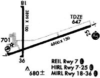
Runways
Runway Summary
| Runways: | 07/25 18/36 |
| Longest Runway: | 07/25 is 6499 ft (1981 m) long |
| Runways with an Instrument Approach: | 25 |
KSQI Airport Runway Details
| Runway 07/25 | 6499 ft x 150 ft (1981 m x 46 m) | |
| Runway Length Source: | 3RD PARTY SURVEY as of 07/20/2012 | |
| Surface: | Asphalt - Good condition - Porous friction course | |
| Runway Edge Lights: | High Intensity | |
Runway Weight Bearing Capacity (in thousands of pounds) |
||
| Single Wheel Landing Gear: | 50.0 | |
| Dual Wheel Landing Gear: | 60.0 | |
| Dual Tandem Wheel Landing Gear: | 90.0 | |
Runway 07 |
Runway 25 |
|
Elevation: |
647.6 | 647.2 |
Latitude: |
41-44-21.0305N | 41-44-42.8336N |
Longitude: |
089-41-04.9695W | 089-39-44.3442W |
|
Runway True Alignment: |
070 | 250 |
ILS Type: |
ILS/DME | |
Glide Path Angle: |
3.0 degrees | 0.0 degrees |
Traffic Pattern: |
Left | Left |
Runway Markings Type: |
Nonprecision Instrument | Precision Instrument |
Runway Markings Condition: |
Fair | Fair |
Visual Glide Slope Indicators: |
4-Light PAPI On Left Side Of Runway | |
Approach Light System: |
1,400 Foot Medium Intensity Approach Lighting System With Runway Alignment Indicator Lights | |
REIL: |
Yes | No |
Touchdown Lights: |
No | No |
Centerline Lights: |
No | No |
Threshold Crossing Height: |
49 |
| Runway 18/36 | 3900 ft x 100 ft (1189 m x 30 m) | |
| Runway Length Source: | 3RD PARTY SURVEY as of 07/20/2012 | |
| Surface: | Asphalt - Good condition - Saw-cut or plastic grooved | |
| Runway Edge Lights: | Medium Intensity | |
Runway Weight Bearing Capacity (in thousands of pounds) |
||
| Single Wheel Landing Gear: | 18.0 | |
Runway 18 |
Runway 36 |
|
Elevation: |
642.0 | 644.1 |
Latitude: |
41-44-57.3120N | 41-44-18.7825N |
Longitude: |
089-40-51.2308W | 089-40-51.3489W |
|
Runway True Alignment: |
180 | 000 |
Glide Path Angle: |
0.0 degrees | 0.0 degrees |
Traffic Pattern: |
Left | Left |
Runway Markings Type: |
Basic | Basic |
Runway Markings Condition: |
Good | Good |
REIL: |
Yes | Yes |
Touchdown Lights: |
No | No |
Centerline Lights: |
No | No |
Services
Airframe Repair: |
Major |
Powerplant Repair: |
Major |
Bottled Oxygen: |
High Pressure / Low Pressure |
Bulk Oxygen: |
None |
Fuel Available: |
100LL, Jet A |
Landing Fees: |
No |
Parking: |
Hangars and tiedowns available |
Maps & Diagrams
KSQI Sectional
Flight Planning
at skyvector.com
at skyvector.com