Location
Latitude: |
40-45-05.7140N (40.751587) |
Longitude: |
095-24-49.0470W (-95.413624) |
Elevation: |
971.1 feet MSL (296 m MSL) |
Magnetic Variation: |
1.7 E (as of April 2024 from WMM2020 model) |
Time Zone: |
UTC -6.0 (Standard Time) UTC -5.0 (Daylight Savings Time) |
From City: |
03 N.M. SW of Shenandoah, Iowa |
Found On: |
Omaha Chart |
FAA Region: |
ACE |
Contacts
Manager: |
Publicly owned: |
| RANDY WAGNER 2033 MANTI ROAD SHENANDOAH, IA 51601 712-246-1931 |
CITY OF SHENANDOAH 500 WEST CLARINDA SHENANDOAH, IA 51601 712-246-4411 |
Operations
Airport Status: |
Operational |
Facility Use: |
Public |
Type: |
Airport |
Activation Date: |
04/1946 |
Control tower: |
No |
Attendance (Months/Days/Hours): |
Months/Days/Hours ALL/MON - SAT/0800-1700 |
Boundary ARTCC: |
ZMP (Minneapolis) |
Responsible ARTCC: |
ZMP (Minneapolis) |
Lighting Schedule: |
SEE RMK |
Segmented Circle Indicator: |
Yes |
Traffic Pattern Altitude (MSL): |
1971 feet (601 m) |
NOTAMs Facility: |
SDA |
NOTAM-D Service: |
Yes |
International Airport of Entry: |
No |
Customs Landing Rights: |
No |
Military Landing Rights: |
Yes |
Civil/Military Joint Use: |
No |
Based Aircraft
| Single Engine: | 16 |
Annual Operations (as of 10/11/2017)
| Total Operations: | 3500 | |
| GA Local: | 1510 | 43.1% |
| GA Itinerant: | 1990 | 56.9% |
Communications
| CTAF: | 122.800 |
| Unicom: | 122.800 |
| Approach: | OMAHA 124.5 124.5 |
| Departure: | OMAHA 124.5 124.5 |
| AWOS-3: | 125.525 (712-246-4021) |
Fixed Based Operators (FBOs) & Fuel
(Click on a business for detail)
Please help us keep this information up to date. This is a FREE SERVICE just like everything else on Airport Guide! If you see that a business needs to be added, modified, or deleted please fill out our Update Form.
To add, modify, or delete a business click here.
Please help us keep this information up to date. This is a FREE SERVICE just like everything else on Airport Guide! If you see that a business needs to be added, modified, or deleted please fill out our Update Form.
Area Code: 712 |
| Business Name | Frequency | Phone | Fuel Grade |
|---|---|---|---|
| Shenandoah Aviation, Inc.
Update FBO info |
Unicom 122.8 | 246-1931 | 100LL, Jet A |
Flight Service Stations
| Primary | Alternate | |
| FSS on Field: | N | |
| FSS Name (ID): | Fort Dodge(FOD) | |
| Frequency: | ||
| Toll Free Phone: | 1-800-WX-BRIEF |
Instrument Procedures / Charts
FAA Terminal Procedures valid from 0901Z 03/21/24 to 0901Z 04/18/24.
There are various types of charts available for an airport. They are listed in the Page Type column. Here is a legend for those types:
APD - Airport Diagram
DP - Departure Procedure Charts
HOT - Hot Spots
IAP - Instrument Approach Procedure Charts
MIN - Minimums
STAR - Standard Terminal Arrival Charts
| Page Type | Page Name | Volume | Action Since Last Cycle |
|---|---|---|---|
| IAP | RNAV (GPS) RWY 04 | NC-3 | |
| IAP | VOR/DME RWY 12 | NC-3 | |
| MIN | ALTERNATE MINIMUMS | NC-3 | |
| MIN | TAKEOFF MINIMUMS | NC-3 |
Terminal Procedures are only available for airports in several countries with more being added all the time. If you are looking for a specific country's charts, please send an email to support(at)airportguide.com stating the country name. This will be used to prioritize the implementation.
Navigation Aids (Navaids) near KSDA
| Dist (NM) | ID | Morse Code | Name | Type | Freq | True Hdg | Mag Hdg |
|---|---|---|---|---|---|---|---|
| 0.3 | SDA | . . . _ . . . _ | Shenandoah | NDB | 411 | 88 | 86 |
| 17.4 | RDK | . _ . _ . . _ . _ | Red Oak | NDB | 230 | 24 | 22 |
| 17.6 | ICL | . . _ . _ . . _ . . | Clarinda | NDB | 353 | 95 | 93 |
| 22.2 | AFK | . _ . . _ . _ . _ | Nebraska City | NDB | 347 | 246 | 244 |
| 25.4 | PMV | . _ _ . _ _ . . . _ | Plattsmouth | NDB | 329 | 297 | 295 |
| 28.9 | OVR | _ _ _ . . . _ . _ . | Omaha | VORTAC | 116.30 | 329 | 327 |
| 31.1 | OFF | _ _ _ . . _ . . . _ . | Offutt | TACAN | 111.70 | 315 | 313 |
| 33.2 | CRZ | _ . _ . . _ . _ _ . . | Corning | NDB | 278 | 63 | 62 |
| 33.5 | EN | . _ . | Rikky | NDB | 426 | 327 | 325 |
| 39.0 | OMA | _ _ _ _ _ . _ | Omaha | VOT | 109.00 | 326 | 324 |
| 41.3 | FNB | . . _ . _ . _ . . . | Brenner | NDB | 404 | 191 | 189 |
| 41.4 | MLE | _ _ . _ . . . | Millard | NDB | 371 | 310 | 308 |
| 42.5 | AIO | . _ . . _ _ _ | Atlantic | NDB | 365 | 22 | 20 |
| 44.3 | OM | _ _ _ _ _ | Gerfi | NDB | 320 | 326 | 324 |
| 49.0 | PWE | . _ _ . . _ _ . | Pawnee City | DME | 112.4 | 227 | 225 |
| 49.8 | HNR | . . . . _ . . _ . | Harlan | NDB | 272 | 3 | 1 |
| 49.9 | UNE | . . _ _ . . | Union County | NDB | 379 | 75 | 74 |
| 52.5 | STJ | . . . _ . _ _ _ | St Joseph | VORTAC | 115.50 | 154 | 152 |
| 54.0 | RBA | . _ . _ . . . . _ | Robinson | DME | 108.2 | 180 | 178 |
| 57.0 | AZN | . _ _ _ . . _ . | Amazon | NDB | 233 | 155 | 153 |
Nearby Airports with Fuel
Notices to Airmen (NOTAMS)
Remarks
| A11 | AJ LYMAN- CITY MGR PHONE 712-246-4411. |
| A110-2 | RY 22 IS CALM WIND RY. |
| A110-3 | FOR CD CTC OMAHA APCH AT 402-682-4395. |
| A17 | FOR ATTENDANT AFT HRS CALL (712) 370-2367. |
| A81-APT | ACTVT MIRL RY 04/22; PAPI RYS 04 & 22; VASI RY 30; REIL RYS 04 & 22 - CTAF. |
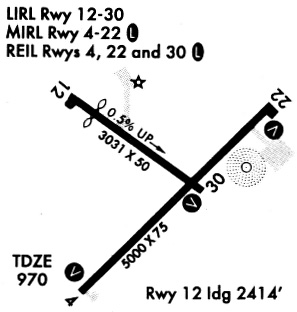
Runways
Runway Summary
| Runways: | 04/22 12/30 |
| Longest Runway: | 04/22 is 5000 ft (1524 m) long |
| Runways with an Instrument Approach: |
KSDA Airport Runway Details
| Runway 04/22 | 5000 ft x 75 ft (1524 m x 23 m) | |
| Runway Length Source: | 3RD PARTY SURVEY as of 09/25/2011 | |
| Surface: | Concrete - Good condition - No special surface treatment | |
| Runway Pavement Class: | 10 /R/C/W/T | |
| Runway Edge Lights: | Medium Intensity | |
Runway Weight Bearing Capacity (in thousands of pounds) |
||
| Single Wheel Landing Gear: | 30.0 | |
| Dual Wheel Landing Gear: | 38.0 | |
Runway 04 |
Runway 22 |
|
Elevation: |
960.7 | 967.9 |
Latitude: |
40-44-43.6008N | 40-45-19.5737N |
Longitude: |
095-25-06.4134W | 095-24-21.8804W |
|
Runway True Alignment: |
043 | 223 |
Glide Path Angle: |
3.0 degrees | 3.0 degrees |
Runway Markings Type: |
Nonprecision Instrument | Nonprecision Instrument |
Runway Markings Condition: |
Fair | Fair |
Object at End: |
ROAD | PLINE |
Object Height: |
33 | 17 |
Distance from End: |
1355 | 900 |
Object Centerline Offset: |
0 ft. left and right of centerline | 0 ft. left and right of centerline |
Visual Glide Slope Indicators: |
2-Light PAPI On Left Side Of Runway | 2-Light PAPI On Left Side Of Runway |
REIL: |
Yes | Yes |
Threshold Crossing Height: |
35 | 33 |
| Runway 12/30 | 3439 ft x 75 ft (1048 m x 23 m) | |
| Runway Length Source: | STATE as of 09/04/2015 | |
| Surface: | Concrete - Good condition - No special surface treatment | |
| Runway Pavement Class: | 6 /R/C/W/T | |
| Runway Edge Lights: | Low Intensity | |
Runway Weight Bearing Capacity (in thousands of pounds) |
||
| Single Wheel Landing Gear: | 4.0 | |
Runway 12 |
Runway 30 |
|
Elevation: |
952.2 | 969.4 |
Latitude: |
40-45-21.4767N | 40-45-01.9500N |
Longitude: |
095-25-14.4533W | 095-24-37.8900W |
|
Runway True Alignment: |
125 | 305 |
Glide Path Angle: |
0.0 degrees | 3.5 degrees |
Traffic Pattern: |
Left | Left |
Runway Markings Type: |
Nonprecision Instrument | Nonprecision Instrument |
Runway Markings Condition: |
Good | Good |
Object at End: |
TREES | |
Object Height: |
16 | |
Distance from End: |
568 | |
Object Centerline Offset: |
0 ft. left and right of centerline | 0 ft. left and right of centerline |
Visual Glide Slope Indicators: |
4-Box VASI On Left Side Of Runway | |
REIL: |
No | |
Threshold Crossing Height: |
42 |
Services
Airframe Repair: |
Major |
Powerplant Repair: |
Major |
Bottled Oxygen: |
None |
Bulk Oxygen: |
None |
Fuel Available: |
100LL, Jet A |
Landing Fees: |
No |
Parking: |
Hangars and tiedowns available |
Maps & Diagrams
KSDA Sectional
Flight Planning
at skyvector.com
at skyvector.com