Location
Latitude: |
35-15-33.4190N (35.259283) |
Longitude: |
093-05-33.4400W (-93.092622) |
Elevation: |
409.2 feet MSL (125 m MSL) |
Magnetic Variation: |
0.3 E (as of April 2024 from WMM2020 model) |
Time Zone: |
UTC -6.0 (Standard Time) UTC -5.0 (Daylight Savings Time) |
From City: |
02 N.M. SE of Russellville, Arkansas |
Found On: |
Memphis Chart |
FAA Region: |
ASW |
Contacts
Manager: |
Publicly owned: |
| PATRICK KARP 1759 AIRPORT ROAD RUSSELLVILLE, AR 72802 479-967-1227 |
CITY OF RUSSELLVILLE 203 S. COMMERCE STR RUSSELLVILLE, AR 72801 479-968-2098 |
Operations
Airport Status: |
Operational |
Facility Use: |
Public |
Type: |
Airport |
Activation Date: |
09/1960 |
Control tower: |
No |
Attendance (Months/Days/Hours): |
Months/Days/Hours ALL/SAT-SUN/0800-1800 |
Boundary ARTCC: |
ZME (Memphis) |
Responsible ARTCC: |
ZME (Memphis) |
Lighting Schedule: |
SEE RMK |
Segmented Circle Indicator: |
Yes, Lighted |
Traffic Pattern Altitude (MSL): |
1409 feet (429 m) |
NOTAMs Facility: |
RUE |
NOTAM-D Service: |
Yes |
International Airport of Entry: |
No |
Customs Landing Rights: |
No |
Military Landing Rights: |
Yes |
Civil/Military Joint Use: |
No |
Based Aircraft
| Single Engine: | 35 |
| Multi Engine: | 7 |
| Jet Engine: | 1 |
| GA Helicopters: | 3 |
Annual Operations (as of 06/30/2021)
| Total Operations: | 10300 | |
| Air Taxi: | 100 | 1.0% |
| GA Local: | 5000 | 48.5% |
| GA Itinerant: | 5000 | 48.5% |
| Military Aircraft: | 200 | 1.9% |
Communications
| CTAF: | 122.700 |
| Unicom: | 122.700 |
| ASOS: | 132.475 (479-968-2267) |
- APCH/DEP SVC PRVDD BY MEMPHIS ARTCC ON FREQS 128.475/377.15 (RUSSELLVILLE RCAG).
Fixed Based Operators (FBOs) & Fuel
(Click on a business for detail)
Please help us keep this information up to date. This is a FREE SERVICE just like everything else on Airport Guide! If you see that a business needs to be added, modified, or deleted please fill out our Update Form.
To add, modify, or delete a business click here.
Please help us keep this information up to date. This is a FREE SERVICE just like everything else on Airport Guide! If you see that a business needs to be added, modified, or deleted please fill out our Update Form.
Area Code: 501 |
| Business Name | Frequency | Phone | Fuel Grade |
|---|---|---|---|
| Aircraft Maintenance Center
Update FBO info |
Unicom 122.7 | 968-1250 | |
| Tallyho Aviation
Website Update FBO info |
Unicom 122.7 | 479-890-6677 | 100LL |

|
 Exxon |
100LL - 2.37 USD per gallon on 12/23/01 |
Pumps |
Flight Service Stations
| Primary | Alternate | |
| FSS on Field: | N | |
| FSS Name (ID): | Jonesboro(JBR) | |
| Frequency: | ||
| Toll Free Phone: | 1-800-WX-BRIEF |
Instrument Procedures / Charts
FAA Terminal Procedures valid from 0901Z 03/21/24 to 0901Z 04/18/24.
There are various types of charts available for an airport. They are listed in the Page Type column. Here is a legend for those types:
APD - Airport Diagram
DP - Departure Procedure Charts
HOT - Hot Spots
IAP - Instrument Approach Procedure Charts
MIN - Minimums
STAR - Standard Terminal Arrival Charts
| Page Type | Page Name | Volume | Action Since Last Cycle |
|---|---|---|---|
| IAP | NDB-A | SC-1 | |
| IAP | RNAV (GPS) RWY 07 | SC-1 | |
| IAP | RNAV (GPS) RWY 25 | SC-1 | |
| MIN | ALTERNATE MINIMUMS | SC-1 | |
| MIN | TAKEOFF MINIMUMS | SC-1 |
Terminal Procedures are only available for airports in several countries with more being added all the time. If you are looking for a specific country's charts, please send an email to support(at)airportguide.com stating the country name. This will be used to prioritize the implementation.
Navigation Aids (Navaids) near KRUE
| Dist (NM) | ID | Morse Code | Name | Type | Freq | True Hdg | Mag Hdg |
|---|---|---|---|---|---|---|---|
| 0.2 | RUE | . _ . . . _ . | Russellville | NDB | 379 | 216 | 216 |
| 11.8 | MPJ | _ _ . _ _ . . _ _ _ | Morrilton | NDB | 410 | 135 | 135 |
| 20.5 | CZE | _ . _ . _ _ . . . | Clarksville | NDB | 201 | 307 | 307 |
| 34.3 | CWS | _ . _ . . _ _ . . . | Conway | NDB | 302 | 107 | 107 |
| 46.8 | HOT | . . . . _ _ _ _ | Hot Springs | VOR-DME | 110.00 | 179 | 179 |
| 50.3 | LRF | . _ . . . _ . . . _ . | Jacksonville | TACAN | 109.20 | 113 | 113 |
| 50.4 | HO | . . . . _ _ _ | Hossy | NDB | 385 | 185 | 185 |
| 52.5 | LI | . _ . . . . | Lasky | NDB | 353 | 132 | 132 |
| 55.3 | FS | . . _ . . . . | Wizer | NDB | 223 | 276 | 275 |
| 55.8 | TYV | _ _ . _ _ . . . _ | Toneyville | NDB | 290 | 108 | 108 |
| 56.0 | HR | . . . . . _ . | Bakky | NDB | 395 | 356 | 356 |
| 56.8 | LIT | . _ . . . . _ | Little Rock | VORTAC | 113.90 | 127 | 127 |
| 58.2 | FSM | . . _ . . . . _ _ | Fort Smith | VORTAC | 110.40 | 277 | 276 |
| 63.8 | HRO | . . . . . _ . _ _ _ | Harrison | VOR-DME | 112.50 | 354 | 354 |
| 64.8 | VM | . . . _ _ _ | Fench | NDB | 352 | 228 | 227 |
| 65.8 | DS | _ . . . . . | Cercy | NDB | 375 | 96 | 96 |
| 67.8 | GK | _ _ . _ . _ | Jembo | NDB | 311 | 273 | 272 |
| 68.6 | BV | _ . . . . . . _ | Almnd | NDB | 335 | 66 | 66 |
| 69.6 | FLP | . . _ . . _ . . . _ _ . | Flippin | DME | 116.05 | 26 | 26 |
| 71.5 | DAK | _ . . . _ _ . _ | Drake | DME | 115.25 | 311 | 310 |
Nearby Airports with Fuel
Notices to Airmen (NOTAMS)
Remarks
| A110-1 | FLOCKS OF MIGRATORY BIRDS INVOF ARPT. |
| A110-2 | DEER ON & INVOF RY. |
| A110-3 | FOR CD CTC MEMPHIS ARTCC AT 901-368-8453/8449. |
| A110-4 | HELI SERVICE CENTER ON FLD. |
| A17 | FOR SVC AFT HRS CALL 479-857-0362 OR 479-857-4076. |
| A57-25 | APCH SLOPE 29:1 TO DSPLCD THLD. |
| A70-FUEL-10 | 0LL SELF SVC FUEL AVBL 24 HRS WITH CREDIT CARD (100 LL) |
| A75 | OPN SHADE HNGRS, LIMITED AVAILABLILITY. |
| A81-APT | DUSK-DAWN. ACTVT REIL RWYS 07 & 25; PAPI RWYS 07 & 25; MIRL 07/25 - CTAF. |
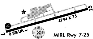
Runways
Runway Summary
| Runways: | 07/25 |
| Longest Runway: | 07/25 is 5505 ft (1678 m) long |
| Runways with an Instrument Approach: |
KRUE Airport Runway Details
| Runway 07/25 | 5505 ft x 75 ft (1678 m x 23 m) | |
| Runway Length Source: | 3RD PARTY SURVEY as of 10/20/2016 | |
| Surface: | Asphalt - Good condition - No special surface treatment | |
| Runway Edge Lights: | Medium Intensity | |
Runway Weight Bearing Capacity (in thousands of pounds) |
||
| Single Wheel Landing Gear: | 32.0 | |
| Dual Wheel Landing Gear: | 46.0 | |
Runway 07 |
Runway 25 |
|
Elevation: |
370.1 | 409.2 |
Latitude: |
35-15-26.3957N | 35-15-40.4396N |
Longitude: |
093-06-05.5070W | 093-05-01.3722W |
|
Runway True Alignment: |
075 | 255 |
Glide Path Angle: |
3.0 degrees | 4.0 degrees |
Traffic Pattern: |
Left | Left |
Runway Markings Type: |
Nonprecision Instrument | Nonprecision Instrument |
Runway Markings Condition: |
Good | Good |
Object at End: |
TREE | TREE |
Object Height: |
35 | 78 |
Distance from End: |
1475 | 1825 |
Object Centerline Offset: |
125 ft. right of centerline | 115 ft. right of centerline |
Visual Glide Slope Indicators: |
4-Light PAPI On Left Side Of Runway | 4-Light PAPI On Left Side Of Runway |
REIL: |
Yes | Yes |
Threshold Crossing Height: |
60 | 83 |
Threshold Elevation: |
403.6 | |
Displaced Threshold: |
706 | |
Threshold Latitude: |
35-15-38.6404N | |
Threshold Longitude: |
093-05-09.5963W |
Services
Airframe Repair: |
Major |
Powerplant Repair: |
Major |
Bottled Oxygen: |
None |
Bulk Oxygen: |
None |
Fuel Available: |
100LL |
Landing Fees: |
No |
Parking: |
Hangars and tiedowns available |
Maps & Diagrams
KRUE Sectional
Flight Planning
at skyvector.com
at skyvector.com