Location
Latitude: |
39-49-03.9350N (39.81776) |
Longitude: |
097-39-34.5110W (-97.659586) |
Elevation: |
1538.0 feet MSL (469 m MSL) |
Magnetic Variation: |
3.3 E (as of April 2024 from WMM2020 model) |
Time Zone: |
UTC -6.0 (Standard Time) UTC -5.0 (Daylight Savings Time) |
From City: |
01 N.M. W of Belleville, Kansas |
Found On: |
Wichita Chart |
FAA Region: |
ACE |
Contacts
Manager: |
Publicly owned: |
| BRIAN PHILLIPS 1819 L ST BELLEVILLE, KS 66935 785-527-3134 |
CITY OF BELLEVILLE 1819 L ST BELLEVILLE, KS 66935 785-527-2288 |
Operations
Airport Status: |
Operational |
Facility Use: |
Public |
Type: |
Airport |
Activation Date: |
05/1945 |
Control tower: |
No |
Attendance (Months/Days/Hours): |
Months/Days/Hours Unattended |
Boundary ARTCC: |
ZMP (Minneapolis) |
Responsible ARTCC: |
ZMP (Minneapolis) |
Lighting Schedule: |
SEE RMK |
Segmented Circle Indicator: |
Yes |
Traffic Pattern Altitude (MSL): |
2538 feet (774 m) |
NOTAMs Facility: |
ICT |
NOTAM-D Service: |
Yes |
International Airport of Entry: |
No |
Customs Landing Rights: |
No |
Military Landing Rights: |
Yes |
Civil/Military Joint Use: |
No |
Based Aircraft
| Single Engine: | 5 |
Annual Operations (as of 10/20/2022)
| Total Operations: | 7250 | |
| GA Local: | 4400 | 60.7% |
| GA Itinerant: | 2800 | 38.6% |
| Military Aircraft: | 50 | 0.7% |
Communications
| CTAF: | 122.800 |
| Unicom: | 122.800 |
- APCH/DEP SVC PRVDD BY MINNEAPOLIS ARTCC (ZMP) ON FREQ 126.4/317.7 (MARYSVILLE RCAG).
Fixed Based Operators (FBOs) & Fuel
(Click on a business for detail)
Please help us keep this information up to date. This is a FREE SERVICE just like everything else on Airport Guide! If you see that a business needs to be added, modified, or deleted please fill out our Update Form.
To add, modify, or delete a business click here.
Please help us keep this information up to date. This is a FREE SERVICE just like everything else on Airport Guide! If you see that a business needs to be added, modified, or deleted please fill out our Update Form.
Area Code: 785 |
| Business Name | Frequency | Phone | Fuel Grade |
|---|
Flight Service Stations
| Primary | Alternate | |
| FSS on Field: | N | |
| FSS Name (ID): | Wichita(ICT) | |
| Frequency: | ||
| Toll Free Phone: | 1-800-WX-BRIEF |
Instrument Procedures / Charts
FAA Terminal Procedures valid from 0901Z 03/21/24 to 0901Z 04/18/24.
There are various types of charts available for an airport. They are listed in the Page Type column. Here is a legend for those types:
APD - Airport Diagram
DP - Departure Procedure Charts
HOT - Hot Spots
IAP - Instrument Approach Procedure Charts
MIN - Minimums
STAR - Standard Terminal Arrival Charts
| Page Type | Page Name | Volume | Action Since Last Cycle |
|---|---|---|---|
| IAP | RNAV (GPS) RWY 18 | NC-2 | |
| IAP | RNAV (GPS) RWY 36 | NC-2 | |
| IAP | VOR-A | NC-2 | |
| MIN | TAKEOFF MINIMUMS | NC-2 |
Terminal Procedures are only available for airports in several countries with more being added all the time. If you are looking for a specific country's charts, please send an email to support(at)airportguide.com stating the country name. This will be used to prioritize the implementation.
Navigation Aids (Navaids) near KRPB
| Dist (NM) | ID | Morse Code | Name | Type | Freq | True Hdg | Mag Hdg |
|---|---|---|---|---|---|---|---|
| 0.3 | RPB | . _ . . _ _ . _ . . . | Republican | NDB | 414 | 163 | 160 |
| 15.9 | CNK | _ . _ . _ . _ . _ | Concordia | NDB | 335 | 178 | 175 |
| 20.2 | HJH | . . . . . _ _ _ . . . . | Hebron | NDB | 323 | 9 | 6 |
| 27.7 | TKO | _ _ . _ _ _ _ | Mankato | VORTAC | 109.80 | 268 | 265 |
| 31.3 | FBY | . . _ . _ . . . _ . _ _ | Fairbury | NDB | 293 | 46 | 43 |
| 34.9 | CYW | _ . _ . _ . _ _ . _ _ | Clay Center | NDB | 362 | 138 | 135 |
| 46.5 | FMZ | . . _ . _ _ _ _ . . | Beklof | NDB | 392 | 5 | 2 |
| 50.7 | BIE | _ . . . . . . | Beatrice | VOR | 110.60 | 54 | 51 |
| 53.6 | SLN | . . . . _ . . _ . | Salina | VORTAC | 117.10 | 178 | 175 |
| 58.9 | HSI | . . . . . . . . . | Hastings | VOR-DME | 108.80 | 323 | 319 |
| 61.1 | MHK | _ _ . . . . _ . _ | Manhattan | VOR-DME | 110.20 | 131 | 128 |
| 62.2 | CVY | _ . _ . . . . _ _ . _ _ | Cavalry | NDB | 314 | 139 | 136 |
| 62.9 | FRI | . . _ . . _ . . . | Fort Riley | VOR | 109.40 | 143 | 140 |
| 64.2 | PSS | . _ _ . . . . . . . | Prosser | NDB | 338 | 324 | 320 |
| 64.8 | JYR | . _ _ _ _ . _ _ . _ . | York | NDB | 257 | 1 | 358 |
| 67.4 | SWT | . . . . _ _ _ | Seward | NDB | 269 | 21 | 18 |
| 68.2 | SL | . . . . _ . . | Flory | NDB | 344 | 179 | 176 |
| 69.3 | LN | . _ . . _ . | Potts | NDB | 385 | 36 | 33 |
| 70.0 | GR | _ _ . . _ . | Sancy | NDB | 380 | 334 | 331 |
| 70.6 | PWE | . _ _ . . _ _ . | Pawnee City | DME | 112.4 | 70 | 67 |
Nearby Airports with Fuel
Notices to Airmen (NOTAMS)
Remarks
| A110-2 | PUBLIC TELEPHONE AVAILABLE IN PILOT'S LOUNGE. |
| A110-4 | OCNL ULTRALIGHT ACTVTY ON & INVOF ARPT. |
| A110-5 | FOR CD CTC MINNEAPOLIS ARTCC AT 651-463-5588. |
| A33-14/32 | RY 14/32 SLIGHTY ROUGH IN SPOTS. |
| A42-14 | APCH DELINEATED BY YELLOW PAINTED CONES. |
| A42-32 | APCH DELINEATED BY ORANGE PAINTED MARKERS. |
| A52-32 | A SMALL SERVICE ROAD RUNS DIAGONALLY ACROSS THE APCH TO RWY 32 APPROXIMATELY 150 T0 200 FT. |
| A70-FUEL-10 | 0LL TRANSPORTATION (AVBL 24 HRS) CTC POLICE DISPATCHER ON 785-527-5657. FUEL BY CREDIT CARD. |
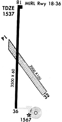
| A81-APT | ACTVT PAPI RWY 18 & 36; MIRL 18/36 - CTAF |
| A84 | SEGMENTED CIRCLE WITH WIND 'T' |
Runways
Runway Summary
| Runways: | 14/32 18/36 |
| Longest Runway: | 18/36 is 3500 ft (1067 m) long |
| Runways with an Instrument Approach: |
KRPB Airport Runway Details
| Runway 14/32 | 1415 ft x 100 ft (431 m x 30 m) | |
| Surface: | Turf - Good condition - No special surface treatment | |
Runway 14 |
Runway 32 |
|
Elevation: |
1520.0 | 1523.0 |
Latitude: |
39-49-03.8208N | 39-48-53.0210N |
Longitude: |
097-39-33.6695W | 097-39-22.1500W |
|
Runway True Alignment: |
141 | 321 |
Glide Path Angle: |
0.0 degrees | 0.0 degrees |
Traffic Pattern: |
Left | Left |
Runway Markings Type: |
Nonstandard (other than numbers only) | Nonstandard (other than numbers only) |
Object at End: |
BLDG | |
Object Height: |
22 | |
Distance from End: |
207 | |
Object Centerline Offset: |
127 ft. right of centerline |
| Runway 18/36 | 3500 ft x 60 ft (1067 m x 18 m) | |
| Runway Length Source: | FAA as of 11/23/2006 | |
| Surface: | Turf - Good condition - No special surface treatment | |
| Runway Edge Lights: | Medium Intensity | |
Runway Weight Bearing Capacity (in thousands of pounds) |
||
| Single Wheel Landing Gear: | 12.5 | |
| Dual Wheel Landing Gear: | 18.0 | |
Runway 18 |
Runway 36 |
|
Elevation: |
1524.0 | 1538.0 |
Latitude: |
39-49-23.4700N | 39-48-48.9000N |
Longitude: |
097-39-36.5800W | 097-39-37.7600W |
|
Runway True Alignment: |
182 | 002 |
Glide Path Angle: |
3.0 degrees | 3.0 degrees |
Traffic Pattern: |
Left | Left |
Runway Markings Type: |
Nonprecision Instrument | Nonprecision Instrument |
Runway Markings Condition: |
Good | Good |
Object at End: |
RR | ROAD |
Object Height: |
23 | 7 |
Distance from End: |
665 | 536 |
Object Centerline Offset: |
127 ft. right of centerline | |
Visual Glide Slope Indicators: |
2-Light PAPI On Left Side Of Runway | 2-Light PAPI On Left Side Of Runway |
Threshold Crossing Height: |
41 | 41 |
Services
Bottled Oxygen: |
None |
Bulk Oxygen: |
None |
Fuel Available: |
100LL |
Landing Fees: |
No |
Parking: |
Tiedowns available |
Maps & Diagrams
KRPB Sectional
Flight Planning
at skyvector.com
at skyvector.com