Location
Latitude: |
45-29-47.7083N (45.496586) |
Longitude: |
091-00-00.6748W (-91.000187) |
Elevation: |
1239.6 feet MSL (378 m MSL) |
Magnetic Variation: |
1.9 W (as of April 2024 from WMM2020 model) |
Time Zone: |
UTC -6.0 (Standard Time) UTC -5.0 (Daylight Savings Time) |
From City: |
04 N.M. NE of Ladysmith, Wisconsin |
Found On: |
Green Bay Chart |
FAA Region: |
AGL |
Contacts
Manager: |
Publicly owned: |
| GARY SHILTS 311 MINER AVE E LADYSMITH, WI 54848 715-609-1300 |
RUSK COUNTY 311 MINER AVE E LADYSMITH, WI 54848 715-415-5529 |
Operations
Airport Status: |
Operational |
Facility Use: |
Public |
Type: |
Airport |
Control tower: |
No |
Attendance (Months/Days/Hours): |
Months/Days/Hours ALL/ALL/IREG |
Boundary ARTCC: |
ZMP (Minneapolis) |
Responsible ARTCC: |
ZMP (Minneapolis) |
Lighting Schedule: |
SEE RMK |
Segmented Circle Indicator: |
Yes |
Traffic Pattern Altitude (MSL): |
2240 feet (683 m) |
NOTAMs Facility: |
RCX |
NOTAM-D Service: |
Yes |
International Airport of Entry: |
No |
Customs Landing Rights: |
No |
Military Landing Rights: |
Yes |
Civil/Military Joint Use: |
No |
Based Aircraft
| Single Engine: | 17 |
| Multi Engine: | 1 |
Annual Operations (as of 07/03/2023)
| Total Operations: | 8070 | |
| Air Taxi: | 800 | 9.9% |
| GA Local: | 4500 | 55.8% |
| GA Itinerant: | 2750 | 34.1% |
| Military Aircraft: | 20 | 0.2% |
Communications
| CTAF: | 122.800 |
| Unicom: | 122.800 |
| AWOS-3: | 118.125 (715-532-2665) |
- COMMUNICATIONS PRVDD BY GREEN BAY RADIO ON FREQ 122.3 (RICE LAKE RCO).
- APCH/DEP SVC PRVDD BY MINNEAPOLIS ARTCC (ZMP) ON FREQ 133.65/281.5 (RHINELANDER RCAG).
Fixed Based Operators (FBOs) & Fuel
(Click on a business for detail)
Please help us keep this information up to date. This is a FREE SERVICE just like everything else on Airport Guide! If you see that a business needs to be added, modified, or deleted please fill out our Update Form.
To add, modify, or delete a business click here.
Please help us keep this information up to date. This is a FREE SERVICE just like everything else on Airport Guide! If you see that a business needs to be added, modified, or deleted please fill out our Update Form.
Area Code: 715 |
| Business Name | Frequency | Phone | Fuel Grade |
|---|---|---|---|
| Classic Aircraft Maintenance
Update FBO info |
532-5480 | ||
| Pedersen Aircraft, Inc.
Update FBO info |
532-6276 | ||
| Rusk County Airport
Update FBO info |
Unicom 122.8 | 532-2635, 532-9819 | 80, 100LL |
Flight Service Stations
| Primary | Alternate | |
| FSS on Field: | N | |
| FSS Name (ID): | Green Bay(GRB) | |
| Frequency: | ||
| Toll Free Phone: | 1-800-WX-BRIEF |
Instrument Procedures / Charts
FAA Terminal Procedures valid from 0901Z 03/21/24 to 0901Z 04/18/24.
There are various types of charts available for an airport. They are listed in the Page Type column. Here is a legend for those types:
APD - Airport Diagram
DP - Departure Procedure Charts
HOT - Hot Spots
IAP - Instrument Approach Procedure Charts
MIN - Minimums
STAR - Standard Terminal Arrival Charts
| Page Type | Page Name | Volume | Action Since Last Cycle |
|---|---|---|---|
| IAP | RNAV (GPS) RWY 14 | EC-3 | |
| IAP | RNAV (GPS) RWY 32 | EC-3 | |
| MIN | ALTERNATE MINIMUMS | EC-3 | |
| MIN | TAKEOFF MINIMUMS | EC-3 |
Terminal Procedures are only available for airports in several countries with more being added all the time. If you are looking for a specific country's charts, please send an email to support(at)airportguide.com stating the country name. This will be used to prioritize the implementation.
Navigation Aids (Navaids) near KRCX
| Dist (NM) | ID | Morse Code | Name | Type | Freq | True Hdg | Mag Hdg |
|---|---|---|---|---|---|---|---|
| 0.3 | RCX | . _ . _ . _ . _ . . _ | Rusk County | NDB | 356 | 353 | 355 |
| 27.6 | PBH | . _ _ . _ . . . . . . . | Phillips | NDB | 263 | 63 | 65 |
| 33.1 | RPD | . _ . . _ _ . _ . . | Rice Lake | VOR-DME | 110.00 | 261 | 263 |
| 35.5 | RP | . _ . . _ _ . | Wickr | NDB | 221 | 252 | 254 |
| 36.4 | PKF | . _ _ . _ . _ . . _ . | Park Falls | NDB | 371 | 41 | 43 |
| 36.5 | HYR | . . . . _ . _ _ . _ . | Hayward | DME | 113.4 | 329 | 331 |
| 36.7 | EA | . . _ | Maggs | NDB | 239 | 205 | 207 |
| 37.5 | MDZ | _ _ _ . . _ _ . . | Medford | NDB | 335 | 128 | 130 |
| 41.2 | EAU | . . _ . . _ | Eau Claire | VORTAC | 113.65 | 209 | 211 |
| 57.0 | DO | _ . . _ _ _ | Dougy | NDB | 236 | 68 | 70 |
| 57.5 | RRL | . _ . . _ . . _ . . | Merrill | NDB | 257 | 107 | 109 |
| 58.6 | RH | . _ . . . . . | Arsha | NDB | 272 | 81 | 84 |
| 59.2 | ARV | . _ . _ . . . . _ | Arbor Vitae | NDB | 221 | 63 | 65 |
| 60.0 | VIQ | . . . _ . . _ _ . _ | Neillsville | NDB | 368 | 159 | 161 |
| 60.5 | BXR | _ . . . _ . . _ . _ . | Big Doctor | NDB | 203 | 289 | 290 |
| 60.8 | RZN | . _ . _ _ . . _ . | Siren | DME | 109.4 | 289 | 290 |
| 61.8 | MFI | _ _ . . _ . . . | Marshfield | NDB | 391 | 145 | 147 |
| 63.3 | ASX | . _ . . . _ . . _ | Ashland | VOR-DME | 110.20 | 3 | 5 |
| 65.3 | RHI | . _ . . . . . . . | Rhinelander | VOR-DME | 109.20 | 82 | 85 |
| 66.3 | DU | _ . . . . _ | Calin | NDB | 266 | 146 | 148 |
Nearby Airports with Fuel
Notices to Airmen (NOTAMS)
Remarks
| A110-2 | OCNL DEER INVOF ARPT |
| A110-6 | SELF SERVICE FUEL AVBL 24 HR WITH CREDIT CARD. |
| A110-7 | FOR CD CTC MINNEAPOLIS ARTCC AT 651-463-5588. |
| A81-APT | MIRL RWY 14/32 PRESET TO LOW SS-SR; TO INCR INTST & ACTVT REIL RWY 14 & 32; PAPI RWY 14 & 32; MIRL RWY 01/19 - CTAF. |
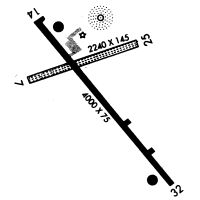
Runways
Runway Summary
| Runways: | 01/19 14/32 |
| Longest Runway: | 14/32 is 4001 ft (1220 m) long |
| Runways with an Instrument Approach: |
KRCX Airport Runway Details
| Runway 01/19 | 3199 ft x 75 ft (975 m x 23 m) | |
| Runway Length Source: | 3RD PARTY SURVEY as of 10/23/2009 | |
| Surface: | Asphalt - Fair condition - No special surface treatment | |
| Runway Edge Lights: | Medium Intensity | |
Runway 01 |
Runway 19 |
|
Elevation: |
1223.4 | 1239.6 |
Latitude: |
45-29-29.7056N | 45-30-01.0539N |
Longitude: |
091-00-02.8291W | 090-59-57.4342W |
|
Runway True Alignment: |
007 | 187 |
Glide Path Angle: |
0.0 degrees | 0.0 degrees |
Runway Markings Type: |
Nonprecision Instrument | Nonprecision Instrument |
Runway Markings Condition: |
Good | Good |
Object at End: |
TREES | |
Object Height: |
100 | |
Distance from End: |
2030 | |
Object Centerline Offset: |
305 ft. right of centerline | |
Touchdown Lights: |
No |
| Runway 14/32 | 4001 ft x 75 ft (1220 m x 23 m) | |
| Runway Length Source: | 3RD PARTY SURVEY as of 10/23/2009 | |
| Surface: | Asphalt - Fair condition - No special surface treatment | |
| Runway Edge Lights: | Medium Intensity | |
Runway Weight Bearing Capacity (in thousands of pounds) |
||
| Single Wheel Landing Gear: | 25.0 | |
Runway 14 |
Runway 32 |
|
Elevation: |
1236.3 | 1226.5 |
Latitude: |
45-30-04.8109N | 45-29-34.3294N |
Longitude: |
091-00-18.9689W | 090-59-43.2491W |
|
Runway True Alignment: |
140 | 320 |
Glide Path Angle: |
3.0 degrees | 3.0 degrees |
Traffic Pattern: |
Left | Left |
Runway Markings Type: |
Nonprecision Instrument | Nonprecision Instrument |
Runway Markings Condition: |
Good | Good |
Object at End: |
TREES | |
Object Height: |
83 | |
Distance from End: |
1620 | |
Object Centerline Offset: |
305 ft. right of centerline | |
Visual Glide Slope Indicators: |
2-Light PAPI On Left Side Of Runway | 2-Light PAPI On Left Side Of Runway |
REIL: |
Yes | Yes |
Touchdown Lights: |
No | No |
Centerline Lights: |
No | No |
Threshold Crossing Height: |
29 | 30 |
Services
Airframe Repair: |
Major |
Powerplant Repair: |
Major |
Fuel Available: |
100LL, Jet A, MOGAS |
Landing Fees: |
No |
Parking: |
Hangars and tiedowns available |
Maps & Diagrams
KRCX Sectional
Flight Planning
at skyvector.com
at skyvector.com