Location
Latitude: |
32-26-19.2000N (32.438667) |
Longitude: |
090-06-11.2000W (-90.103111) |
Elevation: |
325.1 feet MSL (99 m MSL) |
Magnetic Variation: |
1.6 W (as of April 2024 from WMM2020 model) |
Time Zone: |
UTC -6.0 (Standard Time) UTC -5.0 (Daylight Savings Time) |
From City: |
02 N.M. SE of Madison, Mississippi |
Found On: |
Memphis Chart |
FAA Region: |
ASO |
Contacts
Manager: |
Publicly owned: |
| GUY BOWERING PO BOX 40 MADISON, MS 39130 601-853-1960 |
CITY OF MADISON TOWN HALL (PO BOX 40) MADISON, MS 39130 601-856-7116 |
Operations
Airport Status: |
Operational |
Facility Use: |
Public |
Type: |
Airport |
Activation Date: |
03/1941 |
Control tower: |
No |
Attendance (Months/Days/Hours): |
Months/Days/Hours ALL/MON-FRI/0600-2000 |
Boundary ARTCC: |
ZME (Memphis) |
Responsible ARTCC: |
ZME (Memphis) |
Lighting Schedule: |
SEE RMK |
Segmented Circle Indicator: |
Yes |
Traffic Pattern Altitude (MSL): |
1325 feet (404 m) |
NOTAMs Facility: |
GWO |
NOTAM-D Service: |
Yes |
International Airport of Entry: |
No |
Customs Landing Rights: |
No |
Military Landing Rights: |
Yes |
Civil/Military Joint Use: |
No |
Based Aircraft
| Single Engine: | 48 |
| Multi Engine: | 6 |
| Jet Engine: | 1 |
Annual Operations (as of 03/20/2023)
| Total Operations: | 44849 | |
| GA Local: | 24240 | 54.0% |
| GA Itinerant: | 20517 | 45.7% |
| Military Aircraft: | 92 | 0.2% |
Communications
| CTAF: | 122.800 |
| Unicom: | 122.800 |
| Approach: | JACKSON 123.9 ;333-152 123.9 ;333-152 123.9 ;333-152 123.9 ;333-152 123.9 ;333-152 MEMPHIS ARTCC |
| Departure: | JACKSON 123.9 ;333-152 123.9 ;333-152 123.9 ;333-152 123.9 ;333-152 123.9 ;333-152 MEMPHIS ARTCC |
| AWOS-3PT: | 119.125 (601-605-8137) |
- APCH/DEP SVC PRVDD BY MEMPHIS ARTCC ON FREQS 132.5/259.1 (JACKSON RCAG) WHEN JACKSON APCH CTL CLSD.
Fixed Based Operators (FBOs) & Fuel
(Click on a business for detail)
Please help us keep this information up to date. This is a FREE SERVICE just like everything else on Airport Guide! If you see that a business needs to be added, modified, or deleted please fill out our Update Form.
To add, modify, or delete a business click here.
Please help us keep this information up to date. This is a FREE SERVICE just like everything else on Airport Guide! If you see that a business needs to be added, modified, or deleted please fill out our Update Form.
Area Code: 601 |
| Business Name | Frequency | Phone | Fuel Grade |
|---|
Flight Service Stations
| Primary | Alternate | |
| FSS on Field: | N | |
| FSS Name (ID): | Greenwood(GWO) | |
| Frequency: | ||
| Toll Free Phone: | 1-800-WX-BRIEF |
Instrument Procedures / Charts
FAA Terminal Procedures valid from 0901Z 03/21/24 to 0901Z 04/18/24.
There are various types of charts available for an airport. They are listed in the Page Type column. Here is a legend for those types:
APD - Airport Diagram
DP - Departure Procedure Charts
HOT - Hot Spots
IAP - Instrument Approach Procedure Charts
MIN - Minimums
STAR - Standard Terminal Arrival Charts
| Page Type | Page Name | Volume | Action Since Last Cycle |
|---|---|---|---|
| IAP | RNAV (GPS) RWY 17 | SC-4 | |
| IAP | RNAV (GPS) RWY 35 | SC-4 | |
| IAP | VOR RWY 17 | SC-4 | |
| MIN | ALTERNATE MINIMUMS | SC-4 | |
| MIN | TAKEOFF MINIMUMS | SC-4 |
Terminal Procedures are only available for airports in several countries with more being added all the time. If you are looking for a specific country's charts, please send an email to support(at)airportguide.com stating the country name. This will be used to prioritize the implementation.
Navigation Aids (Navaids) near KMBO
| Dist (NM) | ID | Morse Code | Name | Type | Freq | True Hdg | Mag Hdg |
|---|---|---|---|---|---|---|---|
| 0.3 | MHZ | _ _ . . . . _ _ . . | Magnolia | VORTAC | 113.20 | 148 | 150 |
| 1.8 | JA | . _ _ _ . _ | Allen | NDB | 365 | 207 | 209 |
| 5.3 | JAN | . _ _ _ . _ _ . | Jackson | VORTAC | 112.60 | 321 | 323 |
| 7.9 | JAN | . _ _ _ . _ _ . | Jackson | VOT | 111.00 | 166 | 168 |
| 8.2 | JH | . _ _ _ . . . . | Brenz | NDB | 260 | 259 | 261 |
| 17.6 | RYB | . _ . _ . _ _ _ . . . | Raymond | NDB | 375 | 242 | 244 |
| 48.2 | TKH | _ _ . _ . . . . | Tallulah | NDB | 344 | 256 | 257 |
| 59.7 | BLE | _ . . . . _ . . . | Lake Providence | NDB | 278 | 293 | 294 |
| 62.1 | SQS | . . . _ _ . _ . . . | Sidon | VORTAC | 114.70 | 351 | 353 |
| 64.7 | THJ | _ . . . . . _ _ _ | Tallahala | NDB | 346 | 133 | 135 |
| 65.9 | MEI | _ _ . . . | Meridian | VORTAC | 117.00 | 92 | 94 |
| 68.5 | ME | _ _ . | Savoy | NDB | 356 | 99 | 101 |
| 68.5 | MCB | _ _ _ . _ . _ . . . | Mc Comb | VORTAC | 116.70 | 186 | 188 |
| 69.2 | GW | _ _ . . _ _ | Teock | NDB | 349 | 0 | 2 |
| 72.6 | LBY | . _ . . _ . . . _ . _ _ | Eaton | VORTAC | 110.60 | 147 | 149 |
| 73.9 | MTQ | _ _ _ _ _ . _ | Metcalf | NDB | 359 | 323 | 324 |
| 74.0 | MC | _ _ _ . _ . | Ferni | NDB | 413 | 196 | 197 |
| 75.3 | HAH | . . . . . _ . . . . | Natchez-Adams County | NDB | 388 | 233 | 234 |
| 78.3 | HEZ | . . . . . _ _ . . | Natchez | VOR-DME | 110.00 | 231 | 232 |
| 78.7 | GLH | _ _ . . _ . . . . . . | Greenville | VOR-DME | 114.25 | 326 | 327 |
Nearby Airports with Fuel
Notices to Airmen (NOTAMS)
Remarks
| A110-4 | WHEN APCH CLSD, FOR CD CTC MEMPHIS ARTCC AT 901-368-8453/8449. |
| A43-35 | PAPI OTS INDEF. |
| A81-APT | ACTVT PAPI RWY 17 & 35; MIRL RWY 17/35 - CTAF. |
Runways
Runway Summary
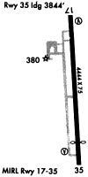
| Runways: | 17/35 |
| Longest Runway: | 17/35 is 4444 ft (1355 m) long |
| Runways with an Instrument Approach: |
KMBO Airport Runway Details
| Runway 17/35 | 4444 ft x 75 ft (1355 m x 23 m) | |
| Runway Length Source: | 3RD PARTY SURVEY as of 12/22/2010 | |
| Surface: | Asphalt - Good condition - No special surface treatment | |
| Runway Edge Lights: | Medium Intensity | |
Runway Weight Bearing Capacity (in thousands of pounds) |
||
| Single Wheel Landing Gear: | 25.0 | |
Runway 17 |
Runway 35 |
|
Elevation: |
325.1 | 314.0 |
Latitude: |
32-26-41.1008N | 32-25-57.2793N |
Longitude: |
090-06-13.2576W | 090-06-09.0394W |
|
Runway True Alignment: |
175 | 355 |
Glide Path Angle: |
3.0 degrees | 4.0 degrees |
Traffic Pattern: |
Left | Left |
Runway Markings Type: |
Nonprecision Instrument | Nonprecision Instrument |
Runway Markings Condition: |
Good | Good |
Object at End: |
TREES | TREES |
Object Height: |
66 | 71 |
Distance from End: |
1540 | 1650 |
Object Centerline Offset: |
200 ft. right of centerline | 200 ft. left of centerline |
Visual Glide Slope Indicators: |
2-Light PAPI On Left Side Of Runway | 2-Light PAPI On Left Side Of Runway |
Threshold Crossing Height: |
38 | 54 |
Services
Airframe Repair: |
Major |
Powerplant Repair: |
Major |
Bottled Oxygen: |
None |
Bulk Oxygen: |
None |
Fuel Available: |
100LL, Jet A |
Landing Fees: |
No |
Parking: |
Tiedowns available |
Maps & Diagrams
KMBO Sectional
Flight Planning
at skyvector.com
at skyvector.com