Location
Latitude: |
35-28-59.3100N (35.483142) |
Longitude: |
081-09-41.4200W (-81.161506) |
Elevation: |
877.9 feet MSL (268 m MSL) |
Magnetic Variation: |
7.8 W (as of April 2024 from WMM2020 model) |
Time Zone: |
UTC -5.0 (Standard Time) UTC -4.0 (Daylight Savings Time) |
From City: |
05 N.M. E of Lincolnton, North Carolina |
Found On: |
Charlotte Chart |
FAA Region: |
ASO |
Contacts
Manager: |
Publicly owned: |
| SCOTT STIMPSON 714 JACK DELLINGER DRIVE IRON STATION, NC 28080 704-735-0602 |
CITY OF LINCOLNTON & LINCOLN 714 JACK DELLINGER DRIVE IRON STATION, NC 28080 704-736-8488 |
Operations
Airport Status: |
Operational |
Facility Use: |
Public |
Type: |
Airport |
Activation Date: |
07/1986 |
Control tower: |
No |
Attendance (Months/Days/Hours): |
Months/Days/Hours APR-OCT/ALL/0800-1900 |
Boundary ARTCC: |
ZTL (Atlanta) |
Responsible ARTCC: |
ZTL (Atlanta) |
Lighting Schedule: |
SEE RMK |
Segmented Circle Indicator: |
Yes |
Traffic Pattern Altitude (MSL): |
1878 feet (572 m) |
NOTAMs Facility: |
IPJ |
NOTAM-D Service: |
Yes |
Based Aircraft
| Single Engine: | 77 |
| Multi Engine: | 8 |
| Jet Engine: | 3 |
| GA Helicopters: | 1 |
Annual Operations (as of 07/04/2021)
| Total Operations: | 34100 | |
| GA Local: | 15300 | 44.9% |
| GA Itinerant: | 17900 | 52.5% |
| Military Aircraft: | 900 | 2.6% |
Communications
| CTAF: | 123.050 |
| Unicom: | 123.050 |
| Approach: | CHARLOTTE |
| Departure: | CHARLOTTE |
| AWOS-3: | 119.675 (704-735-6954) |
Fixed Based Operators (FBOs) & Fuel
(Click on a business for detail)
Please help us keep this information up to date. This is a FREE SERVICE just like everything else on Airport Guide! If you see that a business needs to be added, modified, or deleted please fill out our Update Form.
To add, modify, or delete a business click here.
Please help us keep this information up to date. This is a FREE SERVICE just like everything else on Airport Guide! If you see that a business needs to be added, modified, or deleted please fill out our Update Form.
Area Code: 704 |
| Business Name | Frequency | Phone | Fuel Grade |
|---|---|---|---|
| Corporate Air Fleet
Website Update FBO info |
7328821, 800-991-0129 | ||
| Lincolnton-Lincoln County Regional Airport
Update FBO info |
Unicom 123.05 | 735-0602 | 100LL, Jet A |
| Ward Aviation
Update FBO info |
735-2330 |
Flight Service Stations
| Primary | Alternate | |
| FSS on Field: | N | |
| FSS Name (ID): | Raleigh(RDU) | |
| Frequency: | ||
| Toll Free Phone: | 1-800-WX-BRIEF |
Instrument Procedures / Charts
FAA Terminal Procedures valid from 0901Z 03/21/24 to 0901Z 04/18/24.
There are various types of charts available for an airport. They are listed in the Page Type column. Here is a legend for those types:
APD - Airport Diagram
DP - Departure Procedure Charts
HOT - Hot Spots
IAP - Instrument Approach Procedure Charts
MIN - Minimums
STAR - Standard Terminal Arrival Charts
| Page Type | Page Name | Volume | Action Since Last Cycle |
|---|---|---|---|
| DP | BARMY FIVE (RNAV) | SE-2 | Changed |
| DP | BEAVY SIX (RNAV) | SE-2 | Changed |
| DP | BOBZY FIVE (RNAV) | SE-2 | Changed |
| DP | ESTRR FIVE (RNAV) | SE-2 | Changed |
| DP | ICONS FIVE (RNAV) | SE-2 | Changed |
| DP | JOJJO FIVE (RNAV) | SE-2 | Changed |
| DP | KERMIT FOUR | SE-2 | Changed |
| DP | KERMIT FOUR[DELIMITER] CONT.1 | SE-2 | Changed |
| DP | KILNS FIVE (RNAV) | SE-2 | Changed |
| DP | KNIGHTS THREE | SE-2 | Changed |
| DP | KNIGHTS THREE[DELIMITER] CONT.1 | SE-2 | Changed |
| DP | KRITR SIX (RNAV) | SE-2 | Changed |
| DP | KWEEN FIVE (RNAV) | SE-2 | Changed |
| DP | LILLS THREE (RNAV) | SE-2 | Changed |
| DP | WEAZL FIVE (RNAV) | SE-2 | Changed |
| IAP | ILS Y OR LOC Y RWY 23 | SE-2 | |
| IAP | ILS Z OR LOC Z RWY 23 | SE-2 | |
| IAP | RNAV (GPS) RWY 05 | SE-2 | |
| IAP | RNAV (GPS) RWY 23 | SE-2 | |
| MIN | ALTERNATE MINIMUMS | SE-2 | |
| MIN | TAKEOFF MINIMUMS | SE-2 | |
| STAR | JOOLS ONE (RNAV) | SE-2 | |
| STAR | LIINN THREE | SE-2 | |
| STAR | LIINN THREE[DELIMITER] CONT.1 | SE-2 | |
| STAR | MAJIC FOUR | SE-2 | |
| STAR | RASLN THREE | SE-2 |
Terminal Procedures are only available for airports in several countries with more being added all the time. If you are looking for a specific country's charts, please send an email to support(at)airportguide.com stating the country name. This will be used to prioritize the implementation.
Navigation Aids (Navaids) near KIPJ
| Dist (NM) | ID | Morse Code | Name | Type | Freq | True Hdg | Mag Hdg |
|---|---|---|---|---|---|---|---|
| 4.9 | IZN | . . _ _ . . _ . | Lincolnton | NDB | 432 | 48 | 56 |
| 17.5 | GHJ | _ _ . . . . . . _ _ _ | Stonia | NDB | 260 | 179 | 187 |
| 18.5 | CLT | _ . _ . . _ . . _ | Charlotte | VOT | 112.00 | 147 | 155 |
| 19.1 | HKY | . . . . _ . _ _ . _ _ | Hickory Regional | VOT | 110.00 | 324 | 332 |
| 19.5 | HK | . . . . _ . _ | Tawba | NDB | 332 | 338 | 346 |
| 20.3 | CLT | _ . _ . . _ . . _ | Charlotte | VOR-DME | 115.00 | 149 | 157 |
| 23.5 | BZM | _ . . . _ _ . . _ _ | Barretts Mountain | VOR-DME | 113.75 | 350 | 358 |
| 25.5 | SLP | . . . . _ . . . _ _ . | First River | NDB | 417 | 237 | 245 |
| 28.4 | FIQ | . . _ . . . _ _ . _ | Fiddlers | NDB | 391 | 298 | 306 |
| 29.4 | MRN | _ _ . _ . _ . | Lenoir | FAN MARKER | 309 | 317 | |
| 35.8 | UZ | . . _ _ _ . . | Rally | NDB | 227 | 173 | 181 |
| 36.0 | RU | . _ . . . _ | Rovdy | NDB | 275 | 65 | 73 |
| 37.9 | UKF | . . _ _ . _ . . _ . | Wilki | NDB | 209 | 4 | 12 |
| 38.9 | TWL | _ . _ _ . _ . . | Wesley | NDB | 204 | 144 | 152 |
| 41.9 | DCM | _ . . _ . _ . _ _ | Chester | NDB | 220 | 182 | 190 |
| 46.2 | SPA | . . . . _ _ . . _ | Spartanburg | VORTAC | 115.70 | 234 | 242 |
| 48.0 | LKR | . _ . . _ . _ . _ . | Lancaster | NDB | 400 | 161 | 169 |
| 52.7 | VU | . . . _ . . _ | Aller | NDB | 346 | 89 | 97 |
| 53.3 | BAR | _ . . . . _ . _ . | Hemlock | NDB | 320 | 319 | 327 |
| 53.4 | FRT | . . _ . . _ . _ | Fairmont | NDB | 248 | 229 | 237 |
Nearby Airports with Fuel
Notices to Airmen (NOTAMS)
Remarks
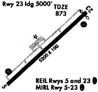
| A110-1 | RWY 23 HAS A 90 FT DROP-OFF 100 FT FM PVMT END AND 90 FT DROP-OFF FIRST 200 FT 160 FT BOTH SIDES OF CNTRLN. |
| A110-101 | FOR CD IF UNA VIA GCO CTC CHARLOTTE APCH AT 704-359-0241. |
| A110-102 | GCO AVBL ON FREQ 124.900 THRU CHARLOTTE APCH; KEY MIKE 4 TIMES SLOWLY, WAIT FOR DIAL TONE AND RING. |
| A110-2 | ARPT PHONE NR 704-735-0602. |
| A110-3 | DEER, COYOTE & BIRDS ON & INVOF ARPT. |
| A17 | UNATTENDED THANKSGIVING AND CHRISTMAS DAY. |
| A31-05/23 | 200 FT SWY SW END HAS BEEN REMARKED AS 200 FT DSPLCD THR FOR RWY 5. |
| A57-05 | APCH SLOPE 18:1 AT DSPLCD THR. |
| A57-23 | APCH SLOPE 31:1 AT DSPLCD THR. |
| A58-05 | DUE TO 19 FT TREES 75-100 FT FR RWY END OFFSET 247 FT LEFT OF CNTRLN. |
| A58-23 | DUE TO 53 FT TREES 0-200 FT FR RWY END OFFSET 475 FT RIGHT OF CNTRLN; DUE TO 10 FT BRUSH 0-200 FT FR RWY END OFFSET 180 FT RIGHT OF CNTRLN; DUE TO 8 FT BRUSH 100-140 FT FR RWY END OFFSET 100 FT LEFT OF CNTRLN. |
| A81-APT | TO ACTVT REIL RWY 05 & 23 DUSK-DAWN - CTAF; TO ACTVT PAPI RWY 05 & 23 - CTAF. MIRL RWY 05/23 DUSK TO 2200 PRESET LOW INTST; TO INCR INTST DUSK TO 2200 AND TO ACTVT MIRL RWY 05/23 BETWEEN 2200-DAWN - CTAF. |
Runways
Runway Summary
| Runways: | 05/23 |
| Longest Runway: | 05/23 is 5700 ft (1737 m) long |
| Runways with an Instrument Approach: | 23 |
KIPJ Heliport Runway Details
| Runway 05/23 | 5700 ft x 100 ft (1737 m x 30 m) | |
| Runway Length Source: | 3RD PARTY SURVEY as of 06/19/2007 | |
| Surface: | Asphalt - Excellent condition - No special surface treatment | |
| Runway Edge Lights: | Medium Intensity | |
Runway Weight Bearing Capacity (in thousands of pounds) |
||
| Single Wheel Landing Gear: | 30.0 | |
| Dual Wheel Landing Gear: | 60.0 | |
Runway 05 |
Runway 23 |
|
Elevation: |
877.9 | 863.1 |
Latitude: |
35-28-40.1400N | 35-29-18.4740N |
Longitude: |
081-10-06.6890W | 081-09-16.1486W |
|
Runway True Alignment: |
047 | 227 |
ILS Type: |
ILS/DME | |
Glide Path Angle: |
3.4 degrees | 3.0 degrees |
Runway Markings Type: |
Precision Instrument | Precision Instrument |
Runway Markings Condition: |
Good | Good |
Object at End: |
TREES | TREES |
Object Height: |
128 | 43 |
Distance from End: |
2194 | 1079 |
Object Centerline Offset: |
96 ft. left of centerline | 251 ft. left of centerline |
Visual Glide Slope Indicators: |
2-Light PAPI On Left Side Of Runway | 2-Light PAPI On Left Side Of Runway |
REIL: |
Yes | Yes |
Threshold Crossing Height: |
64 | 47 |
Threshold Elevation: |
876.5 | 866.1 |
Displaced Threshold: |
200 | 199 |
Threshold Latitude: |
35-28-41.4840N | 35-29-17.1350N |
Threshold Longitude: |
081-10-04.9170W | 081-09-17.9142W |
Services
Airframe Repair: |
Major |
Powerplant Repair: |
Major |
Fuel Available: |
Jet A |
Parking: |
Hangars available |
Maps & Diagrams
KIPJ Sectional
Flight Planning
at skyvector.com
at skyvector.com