
Location
Latitude: |
37-57-21.2338N (37.955898) |
Longitude: |
139-07-15.6079E (139.121002) |
Elevation: |
29 feet MSL (9 m MSL) |
Magnetic Variation: |
8.7 W (as of April 2024 from WMM2020 model) |
Time Zone: |
UTC +9.0 (Standard Time) UTC +9.0 (Daylight Savings Time) |
Contacts
Manager: |
: |
Operations
Airport Status: |
Operational |
Facility Use: |
Public |
Type: |
Airport |
Traffic Pattern Altitude (MSL): |
1029 feet (314 m) |
Based Aircraft
Annual Operations (as of )
Communications
| TWR: | 118 |
| APP: | 121.4 |
| DEP: | 119.05 |
| ATIS: | 128.45 |
Fixed Based Operators (FBOs) & Fuel
(Click on a business for detail)
Please help us keep this information up to date. This is a FREE SERVICE just like everything else on Airport Guide! If you see that a business needs to be added, modified, or deleted please fill out our Update Form.
To add, modify, or delete a business click here.
Please help us keep this information up to date. This is a FREE SERVICE just like everything else on Airport Guide! If you see that a business needs to be added, modified, or deleted please fill out our Update Form.
| Business Name | Frequency | Phone | Fuel Grade |
|---|
Flight Service Stations
| Primary | Alternate | |
| FSS on Field: | ||
| FSS Name (ID): | ||
| Frequency: | ||
| Toll Free Phone: |
Instrument Procedures / Charts
Terminal Procedures are only available for airports in several countries with more being added all the time. If you are looking for a specific country's charts, please send an email to support(at)airportguide.com stating the country name. This will be used to prioritize the implementation.
Navigation Aids (Navaids) near KIJ
| Dist (NM) | ID | Morse Code | Name | Type | Freq | True Hdg | Mag Hdg |
|---|---|---|---|---|---|---|---|
| 0.3 | GTC | Niigata | VORTAC | 115.50 | 296 | 305 | |
| 0.6 | GT | Niigata | NDB | 253 | 240 | 249 | |
| 34.3 | NI | Sado | NDB | 370 | 281 | 290 | |
| 59.1 | ZMO | Zao-Yamada | VOR | 110.80 | 75 | 84 | |
| 60.4 | YSE | Shonai | VOR-DME | 109.60 | 31 | 40 | |
| 63.9 | YTE | Yamagata | VOR-DME | 113.00 | 65 | 74 | |
| 76.4 | FKE | Fukushima | VOR-DME | 113.45 | 124 | 133 | |
| 82.8 | NZE | Nasu | VOR-DME | 114.80 | 147 | 155 | |
| 83.5 | BTE | Batoh | VOR-DME | 109.40 | 148 | 156 | |
| 85.8 | SDE | Sendai | VOR-DME | 116.30 | 82 | 91 | |
| 92.7 | GO | Daigo | NDB | 221 | 140 | 148 | |
| 93.4 | GOC | Daigo | VORTAC | 115.30 | 140 | 148 | |
| 93.6 | JDT | Utsunomiya | TACAN | 112.15 | 157 | 165 | |
| 94.8 | JD | Nikko | NDB | 389 | 157 | 165 |
Nearby Airports with Fuel
| Dist (NM) | Name (Airport IDs) | True Hdg | Mag Hdg | Fuel Grade |
|---|
Notices to Airmen (NOTAMS)
Remarks
No remarks for this landing facility
Runways
Runway Summary
| Runways: | 04/22 10/28 |
| Longest Runway: | 10/28 is 8200 ft (2499 m) long |
| Runways with an Instrument Approach: |
KIJ Airport Runway Details
| Runway 04/22 | 4300 ft x 150 ft (1311 m x 46 m) | |
| Runway Edge Lights: | Yes Intensity | |
Runway 04 |
Runway 22 |
|
Elevation: |
23 | 6 |
Latitude: |
37.94829940795 | 37.95830154418 |
Longitude: |
139.11500549316 | 139.12300109863 |
|
Runway True Alignment: |
31.9 | 211.9 |
Glide Path Angle: |
0.0 degrees | 0.0 degrees |
REIL: |
Yes | Yes |
Threshold Elevation: |
23 | 6 |
| Runway 10/28 | 8200 ft x 150 ft (2499 m x 46 m) | |
| Runway Edge Lights: | Yes Intensity | |
Runway 10 |
Runway 28 |
|
Elevation: |
29 | 12 |
Latitude: |
37.95679855346 | 37.95579910278 |
Longitude: |
139.09599304199 | 139.12399291992 |
|
Runway True Alignment: |
92.7 | 272.7 |
Glide Path Angle: |
0.0 degrees | 0.0 degrees |
REIL: |
Yes | Yes |
Threshold Elevation: |
29 | 12 |
Services
Maps & Diagrams
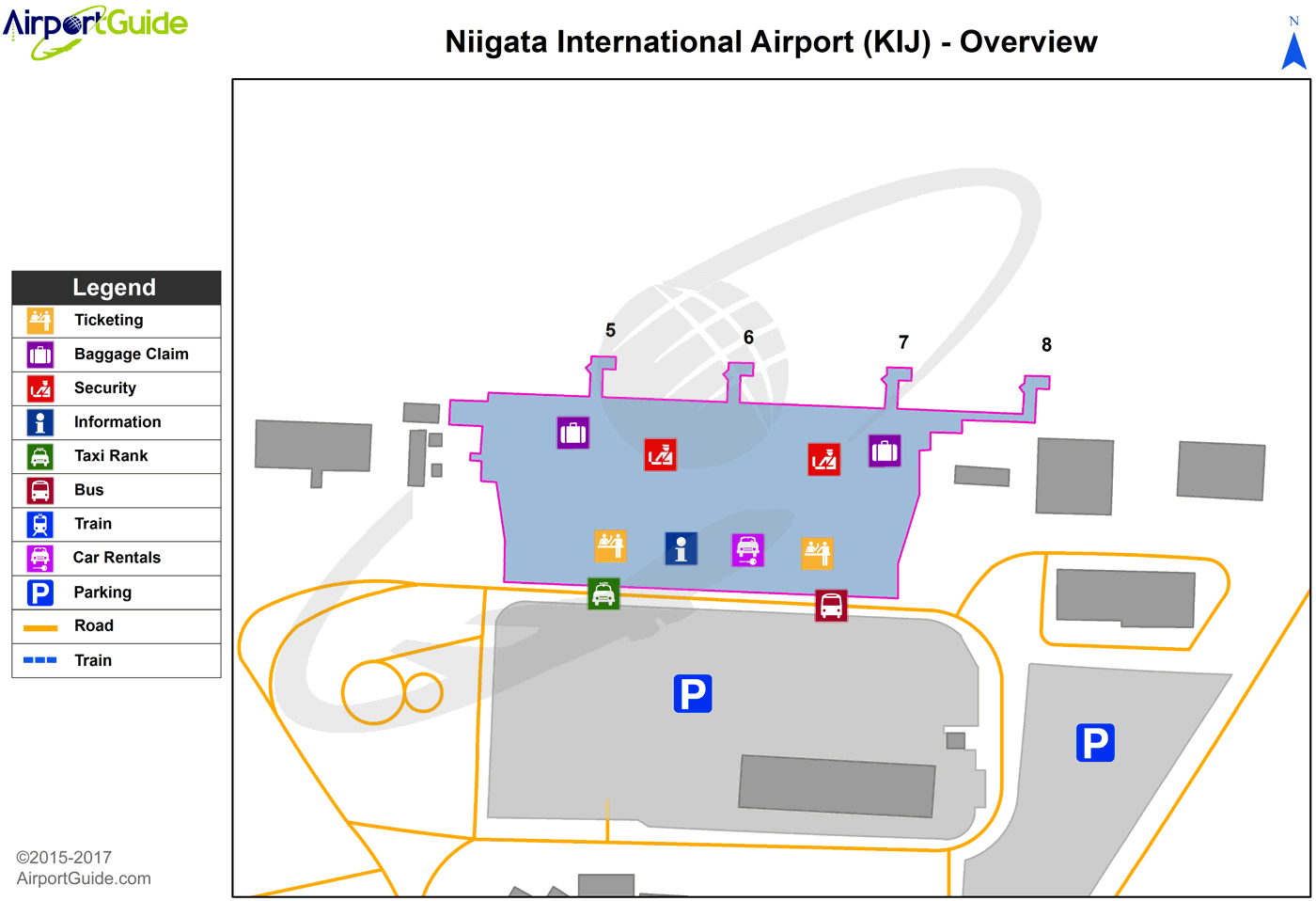
KIJ Sectional
Flight Planning
at skyvector.com
at skyvector.com
