Location
Latitude: |
33-29-08.6000N (33.485722) |
Longitude: |
090-40-44.0000W (-90.678889) |
Elevation: |
126.0 feet MSL (38 m MSL) |
Magnetic Variation: |
1.3 W (as of April 2024 from WMM2020 model) |
Time Zone: |
UTC -6.0 (Standard Time) UTC -5.0 (Daylight Savings Time) |
From City: |
02 N.M. NW of Indianola, Mississippi |
Found On: |
Memphis Chart |
FAA Region: |
ASO |
Contacts
Manager: |
Publicly owned: |
| BAYLOR BRYANT BOX 662 INDIANOLA, MS 38751 662-588-0580 |
CITY OF INDIANOLA PO BOX 269 INDIANOLA, MS 38751 662-887-3101 |
Operations
Airport Status: |
Operational |
Facility Use: |
Public |
Type: |
Airport |
Activation Date: |
01/1947 |
Control tower: |
No |
Attendance (Months/Days/Hours): |
Months/Days/Hours ALL/MON-FRI/0800-1700 |
Boundary ARTCC: |
ZME (Memphis) |
Responsible ARTCC: |
ZME (Memphis) |
Lighting Schedule: |
SEE RMK |
Segmented Circle Indicator: |
Yes |
Traffic Pattern Altitude (MSL): |
1126 feet (343 m) |
NOTAMs Facility: |
GWO |
NOTAM-D Service: |
Yes |
International Airport of Entry: |
No |
Customs Landing Rights: |
No |
Military Landing Rights: |
Yes |
Civil/Military Joint Use: |
No |
Based Aircraft
| Single Engine: | 15 |
| Gliders: | 1 |
Annual Operations (as of 12/08/2023)
| Total Operations: | 26344 | |
| GA Local: | 18992 | 72.1% |
| GA Itinerant: | 7352 | 27.9% |
Communications
| CTAF: | 122.800 |
| Unicom: | 122.800 |
- APCH/DEP SVC PRVDD BY MEMPHIS ARTCC ON FREQS 135.875/269.35 (GREENVILLE RCAG & PINE BLUFF RCAG).
Fixed Based Operators (FBOs) & Fuel
(Click on a business for detail)
Please help us keep this information up to date. This is a FREE SERVICE just like everything else on Airport Guide! If you see that a business needs to be added, modified, or deleted please fill out our Update Form.
To add, modify, or delete a business click here.
Please help us keep this information up to date. This is a FREE SERVICE just like everything else on Airport Guide! If you see that a business needs to be added, modified, or deleted please fill out our Update Form.
Area Code: 662 |
| Business Name | Frequency | Phone | Fuel Grade |
|---|---|---|---|
| Valley Air Applicators
Update FBO info |
887-2861 | 100LL, Jet A |
Flight Service Stations
| Primary | Alternate | |
| FSS on Field: | N | |
| FSS Name (ID): | Greenwood(GWO) | |
| Frequency: | ||
| Toll Free Phone: | 1-800-WX-BRIEF |
Instrument Procedures / Charts
FAA Terminal Procedures valid from 0901Z 03/21/24 to 0901Z 04/18/24.
There are various types of charts available for an airport. They are listed in the Page Type column. Here is a legend for those types:
APD - Airport Diagram
DP - Departure Procedure Charts
HOT - Hot Spots
IAP - Instrument Approach Procedure Charts
MIN - Minimums
STAR - Standard Terminal Arrival Charts
| Page Type | Page Name | Volume | Action Since Last Cycle |
|---|---|---|---|
| IAP | RNAV (GPS) RWY 18 | SC-4 | |
| IAP | RNAV (GPS) RWY 36 | SC-4 | |
| IAP | VOR/DME-A | SC-4 | |
| IAP | VOR/DME-B | SC-4 | |
| MIN | TAKEOFF MINIMUMS | SC-4 |
Terminal Procedures are only available for airports in several countries with more being added all the time. If you are looking for a specific country's charts, please send an email to support(at)airportguide.com stating the country name. This will be used to prioritize the implementation.
Navigation Aids (Navaids) near KIDL
| Dist (NM) | ID | Morse Code | Name | Type | Freq | True Hdg | Mag Hdg |
|---|---|---|---|---|---|---|---|
| 15.4 | GLH | _ _ . . _ . . . . . . | Greenville | VOR-DME | 114.25 | 278 | 279 |
| 15.6 | MTQ | _ _ _ _ _ . _ | Metcalf | NDB | 359 | 256 | 257 |
| 20.1 | SQS | . . . _ _ . _ . . . | Sidon | VORTAC | 114.70 | 93 | 94 |
| 30.4 | GW | _ _ . . _ _ | Teock | NDB | 349 | 77 | 79 |
| 46.9 | SBQ | . . . _ . . . _ _ . _ | Scobey | NDB | 245 | 58 | 60 |
| 46.9 | BLE | _ . . . . _ . . . | Lake Providence | NDB | 278 | 213 | 214 |
| 52.0 | MON | _ _ _ _ _ _ . | Monticello | DME | 111.6 | 275 | 276 |
| 64.1 | JAN | . _ _ _ . _ _ . | Jackson | VORTAC | 112.60 | 156 | 157 |
| 65.4 | UJM | . . _ . _ _ _ _ _ | Marvell | VOR-DME | 109.60 | 0 | 1 |
| 67.7 | JH | . _ _ _ . . . . | Brenz | NDB | 260 | 161 | 162 |
| 69.5 | MHZ | _ _ . . . . _ _ . . | Magnolia | VORTAC | 113.20 | 155 | 156 |
| 70.3 | JA | . _ _ _ . _ | Allen | NDB | 365 | 156 | 157 |
| 72.4 | RYB | . _ . _ . _ _ _ . . . | Raymond | NDB | 375 | 169 | 170 |
| 74.7 | BQP | _ . . . _ _ . _ . _ _ . | Bastrop | NDB | 329 | 234 | 235 |
| 75.2 | UV | . . _ . . . _ | Tunng | NDB | 426 | 43 | 45 |
| 75.9 | TT | _ _ | Stutt | NDB | 338 | 323 | 324 |
| 76.5 | TKH | _ _ . _ . . . . | Tallulah | NDB | 344 | 193 | 194 |
| 77.0 | JAN | . _ _ _ . _ _ . | Jackson | VOT | 111.00 | 156 | 157 |
| 77.1 | PBF | . _ _ . _ . . . . . _ . | Pine Bluff | VOR-DME | 116.00 | 306 | 307 |
| 84.0 | SGT | . . . _ _ . _ | Stuttgart | NDB | 269 | 327 | 328 |
Nearby Airports with Fuel
Notices to Airmen (NOTAMS)
Remarks
| A110-3 | (E81) TWY LGTS ON E-W TWY TO APN ONLY. |
| A110-4 | FOR CD CTC MEMPHIS ARTCC AT 901-368-8453/8449. |
| A75 | PILOTS MUST PRVD THEIR OWN TIEDOWN ROPES. |
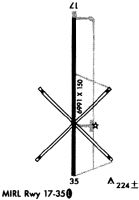
| A81-APT | ACTVT MIRL RWY 18/36 - CTAF. |
Runways
Runway Summary
| Runways: | 18/36 |
| Longest Runway: | 18/36 is 7004 ft (2135 m) long |
| Runways with an Instrument Approach: |
KIDL Airport Runway Details
| Runway 18/36 | 7004 ft x 150 ft (2135 m x 46 m) | |
| Runway Length Source: | 3RD PARTY SURVEY as of 01/23/2008 | |
| Surface: | Concrete - Good condition - No special surface treatment | |
| Runway Edge Lights: | Medium Intensity | |
Runway Weight Bearing Capacity (in thousands of pounds) |
||
| Single Wheel Landing Gear: | 20.0 | |
Runway 18 |
Runway 36 |
|
Elevation: |
126.0 | 120.3 |
Latitude: |
33-29-43.2581N | 33-28-33.9704N |
Longitude: |
090-40-44.0967W | 090-40-43.8168W |
|
Runway True Alignment: |
180 | 360 |
Glide Path Angle: |
0.0 degrees | 0.0 degrees |
Traffic Pattern: |
Left | Left |
Runway Markings Type: |
Nonprecision Instrument | Nonprecision Instrument |
Runway Markings Condition: |
Fair | Good |
Object at End: |
TREES | |
Object Height: |
35 | |
Distance from End: |
1000 | |
Object Centerline Offset: |
0 ft. left and right of centerline |
Services
Bottled Oxygen: |
None |
Bulk Oxygen: |
None |
Fuel Available: |
100LL |
Landing Fees: |
No |
Parking: |
Tiedowns available |
Maps & Diagrams
KIDL Sectional
Flight Planning
at skyvector.com
at skyvector.com