Location
Latitude: |
36-19-00.2000N (36.316722) |
Longitude: |
119-37-39.6000W (-119.627667) |
Elevation: |
239.5 feet MSL (73 m MSL) |
Magnetic Variation: |
12.2 E (as of April 2024 from WMM2020 model) |
Time Zone: |
UTC -8.0 (Standard Time) UTC -7.0 (Daylight Savings Time) |
From City: |
01 N.M. SE of Hanford, California |
Found On: |
San Francisco Chart |
FAA Region: |
AWP |
Contacts
Manager: |
Publicly owned: |
| BOB LOOGMAN 900 SOUTH 10TH AVENUE HANFORD, CA 93230 559-585-2589 |
CITY OF HANFORD 315 N DOUTY ST HANFORD, CA 93230 559-585-2516 |
Operations
Airport Status: |
Operational |
Facility Use: |
Public |
Type: |
Airport |
Activation Date: |
04/1938 |
Control tower: |
No |
Attendance (Months/Days/Hours): |
Months/Days/Hours ALL/ALL/0800-1700 |
Boundary ARTCC: |
ZOA (Oakland) |
Responsible ARTCC: |
ZOA (Oakland) |
Lighting Schedule: |
SEE RMK |
Segmented Circle Indicator: |
Yes |
Traffic Pattern Altitude (MSL): |
1240 feet (378 m) |
NOTAMs Facility: |
HJO |
NOTAM-D Service: |
Yes |
International Airport of Entry: |
No |
Customs Landing Rights: |
No |
Military Landing Rights: |
Yes |
Civil/Military Joint Use: |
No |
Based Aircraft
| Single Engine: | 44 |
| Multi Engine: | 5 |
| Gliders: | 1 |
Annual Operations (as of 12/01/2023)
| Total Operations: | 28700 | |
| Air Taxi: | 200 | 0.7% |
| GA Local: | 14250 | 49.7% |
| GA Itinerant: | 14250 | 49.7% |
Communications
| CTAF: | 122.800 |
| Unicom: | 122.800 |
| Approach: | FRESNO 123.9 123.9 |
| Departure: | FRESNO 123.9 123.9 |
| ASOS: | 134.75 (559-585-8076) |
Fixed Based Operators (FBOs) & Fuel
(Click on a business for detail)
Please help us keep this information up to date. This is a FREE SERVICE just like everything else on Airport Guide! If you see that a business needs to be added, modified, or deleted please fill out our Update Form.
To add, modify, or delete a business click here.
Please help us keep this information up to date. This is a FREE SERVICE just like everything else on Airport Guide! If you see that a business needs to be added, modified, or deleted please fill out our Update Form.
Area Code: 559 |
| Business Name | Frequency | Phone | Fuel Grade |
|---|---|---|---|
| Hanford Flight Center, Inc.
Update FBO info |
Unicom 122.8 | 582-3974 | 100LL |
Flight Service Stations
| Primary | Alternate | |
| FSS on Field: | N | |
| FSS Name (ID): | Rancho Murieta(RIU) | |
| Frequency: | ||
| Toll Free Phone: | 1-800-WX-BRIEF |
Instrument Procedures / Charts
FAA Terminal Procedures valid from 0901Z 03/21/24 to 0901Z 04/18/24.
There are various types of charts available for an airport. They are listed in the Page Type column. Here is a legend for those types:
APD - Airport Diagram
DP - Departure Procedure Charts
HOT - Hot Spots
IAP - Instrument Approach Procedure Charts
MIN - Minimums
STAR - Standard Terminal Arrival Charts
| Page Type | Page Name | Volume | Action Since Last Cycle |
|---|---|---|---|
| IAP | RNAV (GPS) RWY 32 | SW-2 | |
| IAP | RNAV (GPS)-B | SW-2 | |
| MIN | TAKEOFF MINIMUMS | SW-2 |
Terminal Procedures are only available for airports in several countries with more being added all the time. If you are looking for a specific country's charts, please send an email to support(at)airportguide.com stating the country name. This will be used to prioritize the implementation.
Navigation Aids (Navaids) near KHJO
| Dist (NM) | ID | Morse Code | Name | Type | Freq | True Hdg | Mag Hdg |
|---|---|---|---|---|---|---|---|
| 7.7 | VIS | . . . _ . . . . . | Visalia | VOR-DME | 109.40 | 66 | 54 |
| 15.8 | COR | _ . _ . _ _ _ . _ . | Salyer Farms | NDB | 205 | 162 | 150 |
| 16.5 | NLC | _ . . _ . . _ . _ . | Lemoore | TACAN | 113.30 | 275 | 263 |
| 26.4 | FCH | . . _ . _ . _ . . . . . | Chandler | NDB | 344 | 337 | 325 |
| 35.2 | CZQ | _ . _ . _ _ . . _ _ . _ | Clovis | TACAN | 112.90 | 345 | 333 |
| 38.1 | TTE | _ _ . | Tule | VOR-DME | 116.25 | 129 | 117 |
| 43.6 | AVE | . _ . . . _ . | Avenal | VOR-DME | 117.10 | 203 | 191 |
| 47.3 | FRA | . . _ . . _ . . _ | Friant | VORTAC | 115.60 | 1 | 349 |
| 51.3 | ROM | . _ . _ _ _ _ _ | Priest | VOR | 110.00 | 258 | 246 |
| 56.2 | EHF | . . . . . . . _ . | Shafter | VORTAC | 115.40 | 152 | 140 |
| 60.4 | PXN | . _ _ . _ . . _ _ . | Panoche | VORTAC | 112.60 | 293 | 281 |
| 60.5 | BFL | _ . . . . . _ . . _ . . | Bakersfield | VOT | 111.20 | 152 | 140 |
| 62.0 | PRB | . _ _ . . _ . _ . . . | Paso Robles | VORTAC | 114.30 | 231 | 219 |
| 65.7 | HYP | . . . . _ . _ _ . _ _ . | El Nido | VOR-DME | 114.20 | 325 | 313 |
| 74.3 | FLW | . . _ . . _ . . . _ _ | Fellows | VOR-DME | 117.50 | 189 | 177 |
| 78.6 | HGT | . . . . _ _ . _ | Hunter Liggett | NDB | 209 | 254 | 242 |
| 84.3 | MQO | _ _ _ _ . _ _ _ _ | Morro Bay | VORTAC | 112.40 | 221 | 209 |
| 87.8 | BIH | _ . . . . . . . . . | Bishop | VOR-DME | 109.60 | 43 | 31 |
| 89.8 | UAD | . . _ . _ _ . . | Chualar | NDB | 263 | 277 | 265 |
| 92.7 | GLJ | _ _ . . _ . . . _ _ _ | Guadalupe | VOR | 113.05 | 208 | 196 |
Nearby Airports with Fuel
Notices to Airmen (NOTAMS)
Remarks
| A110-1 | FOR CD CTC FRESNO APCH AT 559-487-5405. |
| A43-32 | PAPI RY 32 UNUSBL BYD 2 NM. |
| A70-FUEL-10 | 0LL FUEL SELF-SERVICE AVBL 24 HRS. |
| A81-APT | AFTER DARK ACTVT REIL RWY 32; MIRL RWY 14/32 - CTAF. |
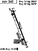
Runways
Runway Summary
| Runways: | 14/32 |
| Longest Runway: | 14/32 is 5179 ft (1579 m) long |
| Runways with an Instrument Approach: |
KHJO Airport Runway Details
| Runway 14/32 | 5179 ft x 75 ft (1579 m x 23 m) | |
| Runway Length Source: | AVN as of 04/10/2003 | |
| Surface: | Asphalt - Good condition - No special surface treatment | |
| Runway Edge Lights: | Medium Intensity | |
Runway Weight Bearing Capacity (in thousands of pounds) |
||
| Single Wheel Landing Gear: | 30.0 | |
| Dual Wheel Landing Gear: | 45.0 | |
Runway 14 |
Runway 32 |
|
Elevation: |
239.5 | 237.5 |
Latitude: |
36-19-22.6844N | 36-18-37.6677N |
Longitude: |
119-37-54.6517W | 119-37-24.4841W |
|
Runway True Alignment: |
151 | 331 |
Glide Path Angle: |
4.0 degrees | 3.0 degrees |
Traffic Pattern: |
Left | Right |
Runway Markings Type: |
Basic | Nonprecision Instrument |
Runway Markings Condition: |
Good | Good |
Object at End: |
ROAD | |
Object Height: |
17 | |
Distance from End: |
245 | |
Object Centerline Offset: |
0 ft. left and right of centerline | |
Visual Glide Slope Indicators: |
4-Light PAPI On Right Side Of Runway | 4-Light PAPI On Left Side Of Runway |
REIL: |
No | Yes |
Touchdown Lights: |
No | No |
Centerline Lights: |
No | No |
Threshold Crossing Height: |
33 | 25 |
Services
Airframe Repair: |
Major |
Powerplant Repair: |
Major |
Fuel Available: |
100LL, Jet A |
Landing Fees: |
No |
Parking: |
Tiedowns available |
Maps & Diagrams
KHJO Sectional
Flight Planning
at skyvector.com
at skyvector.com