Location
Latitude: |
40-55-31.7400N (40.925483) |
Longitude: |
100-08-47.6500W (-100.146569) |
Elevation: |
2558.8 feet MSL (780 m MSL) |
Magnetic Variation: |
4.9 E (as of April 2024 from WMM2020 model) |
Time Zone: |
UTC -6.0 (Standard Time) UTC -5.0 (Daylight Savings Time) |
From City: |
01 N.M. E of Gothenburg, Nebraska |
Found On: |
Omaha Chart |
FAA Region: |
ACE |
Contacts
Manager: |
Publicly owned: |
| GREGORY M. MATTHIES P.O. BOX 267 GOTHENBURG, NE 69138-0267 308-537-2384 |
GOTHENBURG AIRPORT AUTHORITY P.O. BOX 267 GOTHENBURG, NE 69138-0267 (308) 529-2594 |
Operations
Airport Status: |
Operational |
Facility Use: |
Public |
Type: |
Airport |
Activation Date: |
11/1948 |
Control tower: |
No |
Attendance (Months/Days/Hours): |
Months/Days/Hours ALL/MON-FRI/0800-1700 |
Boundary ARTCC: |
ZDV (Denver) |
Responsible ARTCC: |
ZDV (Denver) |
Lighting Schedule: |
SEE RMK |
Segmented Circle Indicator: |
No |
Traffic Pattern Altitude (MSL): |
3559 feet (1085 m) |
NOTAMs Facility: |
OLU |
NOTAM-D Service: |
Yes |
International Airport of Entry: |
No |
Customs Landing Rights: |
No |
Military Landing Rights: |
Yes |
Civil/Military Joint Use: |
No |
Based Aircraft
| Single Engine: | 16 |
Annual Operations (as of 08/05/2021)
| Total Operations: | 600 | |
| GA Local: | 240 | 40.0% |
| GA Itinerant: | 360 | 60.0% |
Communications
| CTAF: | 122.800 |
| Unicom: | 122.800 |
- APCH/DEP CTL SVC PRVDD BY DENVER ARTCC (ZDV) ON FREQS 132.7/226.675 (NORTH PLATTE RCAG).
Fixed Based Operators (FBOs) & Fuel
(Click on a business for detail)
Please help us keep this information up to date. This is a FREE SERVICE just like everything else on Airport Guide! If you see that a business needs to be added, modified, or deleted please fill out our Update Form.
To add, modify, or delete a business click here.
Please help us keep this information up to date. This is a FREE SERVICE just like everything else on Airport Guide! If you see that a business needs to be added, modified, or deleted please fill out our Update Form.
Area Code: 308 |
| Business Name | Frequency | Phone | Fuel Grade |
|---|
Flight Service Stations
| Primary | Alternate | |
| FSS on Field: | N | |
| FSS Name (ID): | Columbus(OLU) | |
| Frequency: | ||
| Toll Free Phone: | 1-800-WX-BRIEF |
Instrument Procedures / Charts
FAA Terminal Procedures valid from 0901Z 03/21/24 to 0901Z 04/18/24.
There are various types of charts available for an airport. They are listed in the Page Type column. Here is a legend for those types:
APD - Airport Diagram
DP - Departure Procedure Charts
HOT - Hot Spots
IAP - Instrument Approach Procedure Charts
MIN - Minimums
STAR - Standard Terminal Arrival Charts
| Page Type | Page Name | Volume | Action Since Last Cycle |
|---|---|---|---|
| IAP | RNAV (GPS) RWY 03 | NC-2 | |
| IAP | RNAV (GPS) RWY 21 | NC-2 | |
| IAP | VOR-A | NC-2 | |
| MIN | TAKEOFF MINIMUMS | NC-2 |
Terminal Procedures are only available for airports in several countries with more being added all the time. If you are looking for a specific country's charts, please send an email to support(at)airportguide.com stating the country name. This will be used to prioritize the implementation.
Navigation Aids (Navaids) near KGTE
| Dist (NM) | ID | Morse Code | Name | Type | Freq | True Hdg | Mag Hdg |
|---|---|---|---|---|---|---|---|
| 4.6 | DWL | _ . . . _ _ . _ . . | Willow | NDB | 353 | 133 | 128 |
| 7.3 | OZB | _ _ _ _ _ . . _ . . . | Cozad | VOR | 109.00 | 117 | 112 |
| 14.0 | RRX | . _ . . _ . _ . . _ | Darr | NDB | 326 | 110 | 105 |
| 21.1 | LB | . _ . . _ . . . | Panbe | NDB | 416 | 294 | 289 |
| 28.2 | LBF | . _ . . _ . . . . . _ . | North Platte | VOR-DME | 117.40 | 285 | 280 |
| 37.3 | CSB | _ . _ . . . . _ . . . | Harry Strunk | NDB | 389 | 180 | 175 |
| 39.4 | CUZ | _ . _ . . . _ _ _ . . | Custer County | VOR-DME | 108.20 | 31 | 26 |
| 45.3 | HCT | . . . . _ . _ . _ | Hayes Center | VORTAC | 117.70 | 231 | 226 |
| 47.9 | MCK | _ _ _ . _ . _ . _ | Mc Cook | VOR-DME | 115.30 | 205 | 200 |
| 48.3 | MCK | _ _ _ . _ . _ . _ | Mc Cook | FAN MARKER | 202 | 197 | |
| 53.2 | EAR | . . _ . _ . | Kearney | VOR | 111.20 | 102 | 97 |
| 54.0 | EA | . . _ | Anoke | NDB | 422 | 109 | 104 |
| 65.3 | NRN | _ . . _ . _ . | Norton | NDB | 230 | 169 | 164 |
| 68.0 | BUB | _ . . . . . _ _ . . . | Burwell | NDB | 377 | 41 | 36 |
| 68.1 | OIN | _ _ _ . . _ . | Oberlin | NDB | 341 | 195 | 190 |
| 68.4 | ODX | _ _ _ _ . . _ . . _ | Ord | NDB | 356 | 51 | 46 |
| 68.4 | TDD | _ _ . . _ . . | Thedford | VOR-DME | 108.60 | 338 | 333 |
| 71.9 | GGF | _ _ . _ _ . . . _ . | Grant | NDB | 359 | 267 | 262 |
| 74.7 | SAE | . . . . _ . | Searle | VOR-DME | 110.20 | 279 | 274 |
| 77.1 | PSS | . _ _ . . . . . . . | Prosser | NDB | 338 | 100 | 96 |
Nearby Airports with Fuel
Notices to Airmen (NOTAMS)
Remarks
| A11 | CHAIRMAN OF ARPT AUTH; ROGER TEDERMAN |
| A110-1 | RY 14/32 NOT PLOWED WINTER MONTHS. |
| A110-2 | MIGRATORY BIRDS IN AREA IN SPRING AND FALL |
| A110-3 | FOR CD CTC DENVER ARTCC AT 303-651-4257. |
| A52-03 | RWY 03 OBSTN IS SEMI TRAILER, CLNC SLP IS 31:1 FM DEP THR. |
| A57-03 | RWY 03 CTLG OBSTN FM DEP THR IS TWR 2157 FT OUT, 107 FT ABV, 514 FT R, CLNC SLP 20:1. |
| A70-FUEL-10 | 0LL 100LL AVAILABLE 24/7 WITH CREDIT CARD. |
| A81-APT | ACTVT MIRL RY 03/21 - CTAF. |
| E111 | EXISTED PRIOR TO 1959. |
Runways
Runway Summary
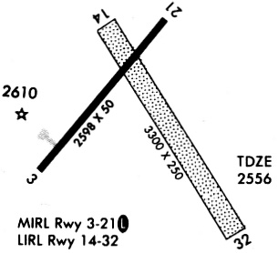
| Runways: | 03/21 14/32 |
| Longest Runway: | 14/32 is 3300 ft (1006 m) long |
| Runways with an Instrument Approach: |
KGTE Airport Runway Details
| Runway 03/21 | 2599 ft x 50 ft (792 m x 15 m) | |
| Runway Length Source: | NGS as of 07/31/1997 | |
| Surface: | Concrete - Good condition - No special surface treatment | |
| Runway Edge Lights: | Medium Intensity | |
Runway Weight Bearing Capacity (in thousands of pounds) |
||
| Single Wheel Landing Gear: | 28.0 | |
Runway 03 |
Runway 21 |
|
Elevation: |
2556.0 | 2558.8 |
Latitude: |
40-55-24.5033N | 40-55-44.6222N |
Longitude: |
100-09-04.4424W | 100-08-43.4132W |
|
Runway True Alignment: |
038 | 218 |
Glide Path Angle: |
0.0 degrees | 0.0 degrees |
Traffic Pattern: |
Left | Left |
Runway Markings Type: |
Nonprecision Instrument | Nonprecision Instrument |
Runway Markings Condition: |
Good | Good |
Object at End: |
OTHER | ROAD |
Object Height: |
11 | 19 |
Distance from End: |
279 | 353 |
Object Centerline Offset: |
170 ft. left of centerline | 273 ft. right of centerline |
Threshold Elevation: |
2556.0 | |
Displaced Threshold: |
70 | |
Threshold Latitude: |
40-55-25.0447N | |
Threshold Longitude: |
100-09-03.8766W |
| Runway 14/32 | 3300 ft x 150 ft (1006 m x 46 m) | |
| Surface: | Concrete - Good condition - No special surface treatment | |
Runway 14 |
Runway 32 |
|
Elevation: |
2555.0 | 2555.0 |
Latitude: |
40-55-43.4400N | 40-55-15.6000N |
Longitude: |
100-08-53.9000W | 100-08-31.5200W |
|
Runway True Alignment: |
149 | 329 |
Glide Path Angle: |
0.0 degrees | 0.0 degrees |
Traffic Pattern: |
Left | Left |
Object at End: |
ROAD | |
Object Height: |
17 | |
Distance from End: |
378 | |
Object Centerline Offset: |
170 ft. left of centerline | 273 ft. right of centerline |
Services
Airframe Repair: |
None |
Powerplant Repair: |
None |
Fuel Available: |
100LL |
Landing Fees: |
No |
Parking: |
Tiedowns available |
Maps & Diagrams
KGTE Sectional
Flight Planning
at skyvector.com
at skyvector.com