Location
Latitude: |
41-11-27.0000N (41.190833) |
Longitude: |
083-23-35.1000W (-83.393083) |
Elevation: |
751.6 feet MSL (229 m MSL) |
Magnetic Variation: |
7.1 W (as of April 2024 from WMM2020 model) |
Time Zone: |
UTC -5.0 (Standard Time) UTC -4.0 (Daylight Savings Time) |
From City: |
02 N.M. NE of Fostoria, Ohio |
Found On: |
Detroit Chart |
FAA Region: |
AGL |
Contacts
Manager: |
Publicly owned: |
| MATT MCVICKER 4495 N COUNTY ROAD 25 FOSTORIA, OH 44830-9565 419-435-0157 |
CITY OF FOSTORIA 213 S MAIN ST FOSTORIA, OH 44830-2322 419-435-2561 |
Operations
Airport Status: |
Operational |
Facility Use: |
Public |
Type: |
Airport |
Activation Date: |
08/1972 |
Control tower: |
No |
Attendance (Months/Days/Hours): |
Months/Days/Hours ALL/ALL/0800-1700 |
Boundary ARTCC: |
ZOB (Cleveland) |
Responsible ARTCC: |
ZOB (Cleveland) |
Lighting Schedule: |
SEE RMK |
Segmented Circle Indicator: |
No |
Traffic Pattern Altitude (MSL): |
1752 feet (534 m) |
NOTAMs Facility: |
CLE |
NOTAM-D Service: |
Yes |
International Airport of Entry: |
No |
Customs Landing Rights: |
No |
Military Landing Rights: |
Yes |
Civil/Military Joint Use: |
No |
Based Aircraft
| Single Engine: | 9 |
| Jet Engine: | 2 |
| GA Helicopters: | 1 |
Annual Operations (as of 10/04/2018)
| Total Operations: | 7950 | |
| Air Taxi: | 400 | 5.0% |
| GA Local: | 3050 | 38.4% |
| GA Itinerant: | 4500 | 56.6% |
Communications
| CTAF: | 122.700 |
| Unicom: | 122.700 |
| Approach: | TOLEDO 126.1 126.1 |
| Departure: | TOLEDO 126.1 126.1 |
| AWOS-3: | 124.625 (419-436-0053) |
Fixed Based Operators (FBOs) & Fuel
(Click on a business for detail)
Please help us keep this information up to date. This is a FREE SERVICE just like everything else on Airport Guide! If you see that a business needs to be added, modified, or deleted please fill out our Update Form.
To add, modify, or delete a business click here.
Please help us keep this information up to date. This is a FREE SERVICE just like everything else on Airport Guide! If you see that a business needs to be added, modified, or deleted please fill out our Update Form.
Area Code: 419 |
| Business Name | Frequency | Phone | Fuel Grade |
|---|---|---|---|
| Fostoria Aero Service, Inc.
Update FBO info |
Unicom 122.7 | 435-0157 | 100LL, Jet A |
Flight Service Stations
| Primary | Alternate | |
| FSS on Field: | N | |
| FSS Name (ID): | Cleveland(CLE) | |
| Frequency: | ||
| Toll Free Phone: | 1-800-WX-BRIEF |
Instrument Procedures / Charts
FAA Terminal Procedures valid from 0901Z 03/21/24 to 0901Z 04/18/24.
There are various types of charts available for an airport. They are listed in the Page Type column. Here is a legend for those types:
APD - Airport Diagram
DP - Departure Procedure Charts
HOT - Hot Spots
IAP - Instrument Approach Procedure Charts
MIN - Minimums
STAR - Standard Terminal Arrival Charts
| Page Type | Page Name | Volume | Action Since Last Cycle |
|---|---|---|---|
| IAP | RNAV (GPS) RWY 09 | EC-2 | |
| IAP | RNAV (GPS) RWY 27 | EC-2 | |
| IAP | VOR-A | EC-2 | |
| MIN | ALTERNATE MINIMUMS | EC-2 | |
| MIN | TAKEOFF MINIMUMS | EC-2 |
Terminal Procedures are only available for airports in several countries with more being added all the time. If you are looking for a specific country's charts, please send an email to support(at)airportguide.com stating the country name. This will be used to prioritize the implementation.
Navigation Aids (Navaids) near KFZI
| Dist (NM) | ID | Morse Code | Name | Type | Freq | True Hdg | Mag Hdg |
|---|---|---|---|---|---|---|---|
| 0.2 | FZI | . . _ . _ _ . . . . | Fostoria | NDB | 379 | 243 | 250 |
| 9.9 | TII | _ . . . . | Tiffin | NDB | 269 | 125 | 132 |
| 16.1 | BNR | _ . . . _ . . _ . | Benton Ridge | NDB | 334 | 230 | 237 |
| 19.2 | VWV | . . . _ . _ _ . . . _ | Waterville | VOR-DME | 113.10 | 324 | 331 |
| 21.7 | FBC | . . _ . _ . . . _ . _ . | Flag City | VORTAC | 108.20 | 229 | 236 |
| 30.3 | TOL | _ _ _ _ . _ . . | Toledo | TACAN | 112.50 | 323 | 330 |
| 30.7 | PCW | . _ _ . _ . _ . . _ _ | Port Clinton | NDB | 423 | 50 | 57 |
| 32.2 | TO | _ _ _ _ | Tophr | NDB | 219 | 312 | 319 |
| 36.3 | SKY | . . . _ . _ _ . _ _ | Sandusky | VOR-DME | 109.20 | 66 | 73 |
| 37.6 | BUD | _ . . . . . _ _ . . | Buckeye | VOR | 109.80 | 156 | 163 |
| 39.0 | AOH | . _ _ _ _ . . . . | Allen County | VOR | 108.40 | 222 | 229 |
| 41.1 | MFD | _ _ . . _ . _ . . | Mansfield | VORTAC | 108.80 | 117 | 124 |
| 41.7 | USE | . . _ . . . . | Fulton | NDB | 375 | 307 | 314 |
| 45.7 | RUV | . _ . . . _ . . . _ | Rushsylvania | NDB | 326 | 195 | 202 |
| 49.9 | MF | _ _ . . _ . | Manns | NDB | 372 | 120 | 127 |
| 51.0 | ADG | . _ _ . . _ _ . | Adrian | NDB | 278 | 323 | 330 |
| 51.5 | CRL | _ . _ . . _ . . _ . . | Carleton | VOR-DME | 115.70 | 356 | 363 |
| 53.3 | AAU | . _ . _ . . _ | Ashland | NDB | 329 | 104 | 112 |
| 55.2 | TCU | _ _ . _ . . . _ | Tecumseh | NDB | 239 | 336 | 343 |
| 55.7 | RYS | . _ . _ . _ _ . . . | Grosse Ile | NDB | 419 | 11 | 18 |
Nearby Airports with Fuel
Notices to Airmen (NOTAMS)
Remarks
| A110-1 | FOR CD CTC TOLEDO APCH AT 419-865-1495. |
| A58-27 | 5 FT CROPS, 0-200 FT DIST, 210 FT L. |
| A81-APT | ACTVT REIL RWY 09 & 27; PAPI RWY 09 & 27; MIRL RWY 09/27 - CTAF. |
Runways
Runway Summary
| Runways: | 09/27 |
| Longest Runway: | 09/27 is 5005 ft (1526 m) long |
| Runways with an Instrument Approach: |
KFZI Airport Runway Details
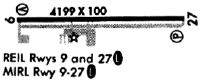
| Runway 09/27 | 5005 ft x 100 ft (1526 m x 30 m) | |
| Runway Length Source: | 3RD PARTY SURVEY as of 04/09/2009 | |
| Surface: | Asphalt - Fair condition - No special surface treatment | |
| Runway Edge Lights: | Medium Intensity | |
Runway Weight Bearing Capacity (in thousands of pounds) |
||
| Single Wheel Landing Gear: | 30.0 | |
| Dual Wheel Landing Gear: | 35.0 | |
| Dual Tandem Wheel Landing Gear: | 52.0 | |
Runway 09 |
Runway 27 |
|
Elevation: |
751.4 | 751.5 |
Latitude: |
41-11-26.9451N | 41-11-27.0514N |
Longitude: |
083-24-07.7792W | 083-23-02.3137W |
|
Runway True Alignment: |
090 | 270 |
Glide Path Angle: |
3.0 degrees | 3.0 degrees |
Traffic Pattern: |
Left | Left |
Runway Markings Type: |
Nonprecision Instrument | Nonprecision Instrument |
Runway Markings Condition: |
Fair | Fair |
Object at End: |
TREES | CROPS |
Object Height: |
61 | 5 |
Distance from End: |
1633 | 201 |
Object Centerline Offset: |
436 ft. right of centerline | 210 ft. right of centerline |
Visual Glide Slope Indicators: |
4-Light PAPI On Left Side Of Runway | 4-Light PAPI On Left Side Of Runway |
REIL: |
Yes | Yes |
Touchdown Lights: |
No | No |
Centerline Lights: |
No | No |
Threshold Crossing Height: |
25 | 40 |
Services
Airframe Repair: |
Minor |
Powerplant Repair: |
Minor |
Fuel Available: |
80, 100LL |
Landing Fees: |
No |
Parking: |
Tiedowns available |
Maps & Diagrams
KFZI Sectional
Flight Planning
at skyvector.com
at skyvector.com