Location
Latitude: |
32-12-59.0000N (32.216389) |
Longitude: |
083-07-43.2000W (-83.128667) |
Elevation: |
303.4 feet MSL (92 m MSL) |
Magnetic Variation: |
6.2 W (as of April 2024 from WMM2020 model) |
Time Zone: |
UTC -5.0 (Standard Time) UTC -4.0 (Daylight Savings Time) |
From City: |
03 N.M. E of Eastman, Georgia |
Found On: |
Atlanta Chart |
FAA Region: |
ASO |
Contacts
Manager: |
Publicly owned: |
| JEFF FORDHAM 317 AIRPORT RD. EASTMAN, GA 31023 478-220-5091 |
HEART OF GA REG APT AUTH 317 AIRPORT RD. EASTMAN, GA 31023 478-220-5091 |
Operations
Airport Status: |
Operational |
Facility Use: |
Public |
Type: |
Airport |
Control tower: |
Yes |
Attendance (Months/Days/Hours): |
Months/Days/Hours ALL/MON-SAT/0800-1800 |
Boundary ARTCC: |
ZJX (Jacksonville) |
Responsible ARTCC: |
ZJX (Jacksonville) |
Lighting Schedule: |
SEE RMK |
Segmented Circle Indicator: |
Yes |
Traffic Pattern Altitude (MSL): |
1303 feet (397 m) |
NOTAMs Facility: |
MCN |
NOTAM-D Service: |
Yes |
International Airport of Entry: |
No |
Customs Landing Rights: |
No |
Military Landing Rights: |
Yes |
Civil/Military Joint Use: |
No |
Based Aircraft
| Single Engine: | 43 |
| Multi Engine: | 3 |
| GA Helicopters: | 5 |
Annual Operations (as of 12/31/2022)
| Total Operations: | 68927 | |
| GA Local: | 45000 | 65.3% |
| GA Itinerant: | 23827 | 34.6% |
| Military Aircraft: | 100 | 0.1% |
Communications
| CTAF: | 124.550 |
| Unicom: | 122.950 |
| Tower: | HEART OF GEORGIA 124.55 Hrs: MON-THU 0600-1500, FRI 0700-1100. |
| Ground: | 121.175 |
| Approach: | JAX ARTCC |
| Departure: | JAX ARTCC |
| ATIS: | 119.425 Hrs: 24 |
| AWOS-3: | 119.425 (478-374-9979) |
- APCH/DEP SVC PRVDD BY JACKSONVILLE ARTCC ON FREQS 127.575/269.025 (ALMA RCAG).
Fixed Based Operators (FBOs) & Fuel
(Click on a business for detail)
Please help us keep this information up to date. This is a FREE SERVICE just like everything else on Airport Guide! If you see that a business needs to be added, modified, or deleted please fill out our Update Form.
To add, modify, or delete a business click here.
Please help us keep this information up to date. This is a FREE SERVICE just like everything else on Airport Guide! If you see that a business needs to be added, modified, or deleted please fill out our Update Form.
Area Code: 478 |
| Business Name | Frequency | Phone | Fuel Grade |
|---|---|---|---|
| World Aircraft
Update FBO info |
Unicom 123.0 | 374-5664, -4411 | 100LL, Jet A |
Flight Service Stations
| Primary | Alternate | |
| FSS on Field: | N | |
| FSS Name (ID): | Macon(MCN) | |
| Frequency: | ||
| Toll Free Phone: | 1-800-WX-BRIEF |
Instrument Procedures / Charts
FAA Terminal Procedures valid from 0901Z 03/21/24 to 0901Z 04/18/24.
There are various types of charts available for an airport. They are listed in the Page Type column. Here is a legend for those types:
APD - Airport Diagram
DP - Departure Procedure Charts
HOT - Hot Spots
IAP - Instrument Approach Procedure Charts
MIN - Minimums
STAR - Standard Terminal Arrival Charts
| Page Type | Page Name | Volume | Action Since Last Cycle |
|---|---|---|---|
| APD | AIRPORT DIAGRAM | SE-4 | |
| IAP | ILS OR LOC RWY 02 | SE-4 | |
| IAP | RNAV (GPS) RWY 02 | SE-4 | |
| IAP | RNAV (GPS) RWY 20 | SE-4 | |
| IAP | VOR/DME-A | SE-4 | |
| MIN | ALTERNATE MINIMUMS | SE-4 | |
| MIN | TAKEOFF MINIMUMS | SE-4 |
Terminal Procedures are only available for airports in several countries with more being added all the time. If you are looking for a specific country's charts, please send an email to support(at)airportguide.com stating the country name. This will be used to prioritize the implementation.
Navigation Aids (Navaids) near KEZM
| Dist (NM) | ID | Morse Code | Name | Type | Freq | True Hdg | Mag Hdg |
|---|---|---|---|---|---|---|---|
| 5.2 | EZM | . _ _ . . _ _ | Eastman | NDB | 366 | 194 | 200 |
| 14.5 | MQW | _ _ _ _ . _ . _ _ | Mc Rae | NDB | 280 | 119 | 125 |
| 17.1 | DB | _ . . _ . . . | Creke | NDB | 251 | 20 | 26 |
| 18.7 | VNA | . . . _ _ . . _ | Vienna | VORTAC | 116.50 | 269 | 275 |
| 25.7 | DBN | _ . . _ . . . _ . | Dublin | VORTAC | 113.10 | 35 | 41 |
| 31.7 | AZE | . _ _ _ . . . | Hazlehurst | NDB | 414 | 129 | 135 |
| 34.6 | WRB | . _ _ . _ . _ . . . | Robins | TACAN | 135.30 | 317 | 323 |
| 35.4 | BEP | _ . . . . . _ _ . | Bay Creek | NDB | 350 | 294 | 300 |
| 37.1 | SUR | . . . . . _ . _ . | Fitzgerald | NDB | 362 | 192 | 198 |
| 38.7 | MCN | _ _ _ . _ . _ . | Macon | DME | 114.2 | 317 | 323 |
| 39.5 | OHY | _ _ _ . . . . _ . _ _ | Coney | NDB | 400 | 250 | 256 |
| 42.2 | UQN | . . _ _ _ . _ _ . | Onyun | NDB | 372 | 89 | 95 |
| 43.6 | EEX | . . _ . . _ | Emanuel County | NDB | 309 | 51 | 57 |
| 45.4 | IZS | . . _ _ . . . . . | Montezuma | NDB | 426 | 281 | 287 |
| 48.3 | BHC | _ . . . . . . . _ . _ . | Baxley | NDB | 376 | 128 | 134 |
| 49.0 | HIT | . . . . . . _ | Kaolin | NDB | 360 | 11 | 17 |
| 49.8 | LKG | . _ . . _ . _ _ _ . | Lindbergh | NDB | 242 | 267 | 273 |
| 49.8 | OWC | _ _ _ . _ _ _ . _ . | Coffee County | NDB | 390 | 167 | 173 |
| 50.5 | RVJ | . _ . . . . _ . _ _ _ | Prison | NDB | 424 | 100 | 107 |
| 50.7 | IFM | . . . . _ . _ _ | Tift Myers | VOR | 112.50 | 201 | 207 |
Nearby Airports with Fuel
Notices to Airmen (NOTAMS)
Remarks
| A110-2 | FLT TRNG IN AREA. |
| A110-3 | DEER AND OTR WILDLIFE INVOF ARPT. |
| A110-4 | CTAF & TWR FREQ - 124.55. |
| A110-5 | FOR CD WHEN ATCT IS CLSD CTC JACKSONVILLE ARTCC AT 904-845-1592. |
| A13 | TWR PHONE 478-448-4713. MGR CELL PHONE 478-231-8305. |
| A16 | TWR PHONE: 478-448-4713. MGR CELL PHONE 478-231-8305 |
| A58-20 | 10 FT TREES, 363 FT RIGHT OF CNTRLN AT THLD. |
| A70-FUEL-10 | 0LL 24 HR SELF-FUELING WITH CREDIT CARD. |
| A81-APT | ACTVT MALSR RWY 02; REIL RWY 20; PAPI RWY 02 & 20; HIRL RWY 02/20 - CTAF. |
| A81-BCN | DUSK-2400. |
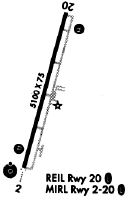
Runways
Runway Summary
| Runways: | 02/20 |
| Longest Runway: | 02/20 is 6506 ft (1983 m) long |
| Runways with an Instrument Approach: | 02 |
KEZM Airport Runway Details
| Runway 02/20 | 6506 ft x 100 ft (1983 m x 30 m) | |
| Runway Length Source: | 3RD PARTY SURVEY as of 04/24/2012 | |
| Surface: | Asphalt - Excellent condition - Saw-cut or plastic grooved | |
| Runway Edge Lights: | High Intensity | |
Runway Weight Bearing Capacity (in thousands of pounds) |
||
| Single Wheel Landing Gear: | 75.0 | |
| Dual Wheel Landing Gear: | 120.0 | |
Runway 02 |
Runway 20 |
|
Elevation: |
295.1 | 298.0 |
Latitude: |
32-12-27.9900N | 32-13-30.0540N |
Longitude: |
083-07-53.2490W | 083-07-33.1466W |
|
Runway True Alignment: |
015 | 195 |
ILS Type: |
LOC/GS | |
Glide Path Angle: |
3.0 degrees | 3.0 degrees |
Traffic Pattern: |
Left | Left |
Runway Markings Type: |
Precision Instrument | Precision Instrument |
Runway Markings Condition: |
Good | Good |
Visual Glide Slope Indicators: |
4-Light PAPI On Left Side Of Runway | 4-Light PAPI On Left Side Of Runway |
Approach Light System: |
1,400 Foot Medium Intensity Approach Lighting System With Runway Alignment Indicator Lights | |
REIL: |
Yes | |
Threshold Crossing Height: |
45 | 45 |
Services
Airframe Repair: |
Minor |
Powerplant Repair: |
Minor |
Bottled Oxygen: |
None |
Bulk Oxygen: |
None |
Fuel Available: |
100LL |
Landing Fees: |
No |
Parking: |
Tiedowns available |
Maps & Diagrams
KEZM Sectional
Flight Planning
at skyvector.com
at skyvector.com