Location
Latitude: |
40-16-46.3517N (40.279542) |
Longitude: |
083-06-48.1810W (-83.113384) |
Elevation: |
945.1 feet MSL (288 m MSL) |
Magnetic Variation: |
7.2 W (as of April 2024 from WMM2020 model) |
Time Zone: |
UTC -5.0 (Standard Time) UTC -4.0 (Daylight Savings Time) |
From City: |
03 N.M. SW of Delaware, Ohio |
Found On: |
Detroit Chart |
FAA Region: |
AGL |
Contacts
Manager: |
Publicly owned: |
| KEVIN PIATT 1075 PITTSBURGH DR DELAWARE, OH 43015-3848 740-203-1870 |
CITY OF DELAWARE 1 S SANDUSKY ST DELAWARE, OH 43015-2326 740-203-1800 |
Operations
Airport Status: |
Operational |
Facility Use: |
Public |
Type: |
Airport |
Activation Date: |
08/1945 |
Control tower: |
No |
Attendance (Months/Days/Hours): |
Months/Days/Hours ALL/ALL/0800-1700 |
Boundary ARTCC: |
ZID (Indianapolis) |
Responsible ARTCC: |
ZID (Indianapolis) |
Lighting Schedule: |
SEE RMK |
Segmented Circle Indicator: |
No |
Traffic Pattern Altitude (MSL): |
1945 feet (593 m) |
NOTAMs Facility: |
DAY |
NOTAM-D Service: |
Yes |
International Airport of Entry: |
No |
Customs Landing Rights: |
No |
Military Landing Rights: |
No |
Civil/Military Joint Use: |
No |
Based Aircraft
| Single Engine: | 80 |
| Multi Engine: | 6 |
| Jet Engine: | 4 |
| GA Helicopters: | 2 |
| Gliders: | 1 |
Annual Operations (as of 09/29/2023)
| Total Operations: | 39300 | |
| Air Taxi: | 3000 | 7.6% |
| GA Local: | 33000 | 84.0% |
| GA Itinerant: | 3300 | 8.4% |
Communications
| CTAF: | 122.700 |
| Unicom: | 122.700 |
| Approach: | COLUMBUS 125.95 125.95 |
| Departure: | COLUMBUS 125.95 125.95 |
| AWOS-3: | 119.025 (740-203-1878) |
Fixed Based Operators (FBOs) & Fuel
(Click on a business for detail)
Please help us keep this information up to date. This is a FREE SERVICE just like everything else on Airport Guide! If you see that a business needs to be added, modified, or deleted please fill out our Update Form.
To add, modify, or delete a business click here.
Please help us keep this information up to date. This is a FREE SERVICE just like everything else on Airport Guide! If you see that a business needs to be added, modified, or deleted please fill out our Update Form.
Area Code: 740 |
| Business Name | Frequency | Phone | Fuel Grade |
|---|
Flight Service Stations
| Primary | Alternate | |
| FSS on Field: | N | |
| FSS Name (ID): | Dayton(DAY) | |
| Frequency: | ||
| Toll Free Phone: | 1-800-WX-BRIEF |
Instrument Procedures / Charts
FAA Terminal Procedures valid from 0901Z 03/21/24 to 0901Z 04/18/24.
There are various types of charts available for an airport. They are listed in the Page Type column. Here is a legend for those types:
APD - Airport Diagram
DP - Departure Procedure Charts
HOT - Hot Spots
IAP - Instrument Approach Procedure Charts
MIN - Minimums
STAR - Standard Terminal Arrival Charts
| Page Type | Page Name | Volume | Action Since Last Cycle |
|---|---|---|---|
| IAP | RNAV (GPS) RWY 10 | EC-2 | |
| IAP | RNAV (GPS) RWY 28 | EC-2 | |
| IAP | VOR RWY 28 | EC-2 | |
| MIN | TAKEOFF MINIMUMS | EC-2 |
Terminal Procedures are only available for airports in several countries with more being added all the time. If you are looking for a specific country's charts, please send an email to support(at)airportguide.com stating the country name. This will be used to prioritize the implementation.
Navigation Aids (Navaids) near KDLZ
| Dist (NM) | ID | Morse Code | Name | Type | Freq | True Hdg | Mag Hdg |
|---|---|---|---|---|---|---|---|
| 13.0 | OS | _ _ _ . . . | Fuler | NDB | 515 | 197 | 204 |
| 16.6 | CHC | _ . _ . . . . . _ . _ . | Grens | NDB | 272 | 166 | 173 |
| 20.0 | CMH | _ . _ . _ _ . . . . | Port Columbus | VOT | 111.00 | 148 | 155 |
| 20.3 | BUD | _ . . . . . _ _ . . | Buckeye | VOR | 109.80 | 6 | 13 |
| 24.1 | CM | _ . _ . _ _ | Sumie | NDB | 391 | 136 | 143 |
| 25.3 | APE | . _ . _ _ . . | Appleton | VORTAC | 116.70 | 107 | 114 |
| 27.1 | LC | . _ . . _ . _ . | Pickl | NDB | 376 | 151 | 158 |
| 27.5 | RUV | . _ . . . _ . . . _ | Rushsylvania | NDB | 326 | 293 | 300 |
| 27.9 | BU | _ . . . . . _ | Boutn | NDB | 230 | 188 | 195 |
| 29.5 | LCK | . _ . . _ . _ . _ . _ | Rickenbacker | TACAN | 69X | 163 | 170 |
| 32.5 | DD | _ . . _ . . | Cobbs | NDB | 253 | 172 | 179 |
| 33.5 | HEH | . . . . . . . . . | Newark | NDB | 524 | 116 | 123 |
| 39.1 | CCJ | _ . _ . _ . _ . . _ _ _ | Clark County | NDB | 341 | 231 | 238 |
| 42.2 | MF | _ _ . . _ . | Manns | NDB | 372 | 46 | 53 |
| 42.6 | ROD | . _ . _ _ _ _ . . | Rosewood | VORTAC | 117.50 | 270 | 277 |
| 42.6 | MFD | _ _ . . _ . _ . . | Mansfield | VORTAC | 108.80 | 33 | 40 |
| 42.6 | XSF | _ . . _ . . . . . _ . | Springfield | TACAN | 133.80 | 231 | 238 |
| 42.7 | CSS | _ . _ . . . . . . . | Court House | NDB | 414 | 197 | 204 |
| 42.8 | SGH | . . . _ _ . . . . . | Springfield | DME | 113.2 | 231 | 238 |
| 45.6 | XUB | _ . . _ . . _ _ . . . | Yellow Bud | VOR | 112.50 | 172 | 179 |
Nearby Airports with Fuel
Notices to Airmen (NOTAMS)
Remarks
| A110-1 | OCNL DEER & OTR WILDLIFE ON & INVOF ARPT. |
| A110-2 | INTMT NGT ACT AT QUARRY OFF WEST END OF RWY 10. |
| A110-3 | ULTRALIGHT TFC RMN S OF RWY AT 400 FT AGL. |
| A110-4 | FOR CD CTC COLUMBUS APCH AT 614-338-8537. |
| A16 | AFT HRS 740-203-1870, OPTION 9. |
| A17 | CLSD THANKSGIVING, CHRISTMAS, & NEW YEARS. |
| A30A-28 | CALM WIND RWY. |
| A43-28 | PAPI UNUSBL BYD 8 DEGS RIGHT OF CNTRLN. |
| A75 | PRIOR CDN RQRD. |
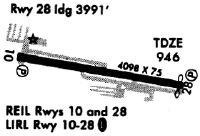
| A81-APT | ACTVT REIL RWY 10 & 28; PAPI RWY 10 & 28; MIRL RWY 10/28 - CTAF. |
| E111 | VFR ONLY. |
Runways
Runway Summary
| Runways: | 10/28 |
| Longest Runway: | 10/28 is 5800 ft (1768 m) long |
| Runways with an Instrument Approach: |
KDLZ Airport Runway Details
| Runway 10/28 | 5800 ft x 100 ft (1768 m x 30 m) | |
| Runway Length Source: | 3RD PARTY SURVEY as of 10/20/2016 | |
| Surface: | Asphalt - Good condition - Saw-cut or plastic grooved | |
| Runway Pavement Class: | 39 /F/C/X/T | |
| Runway Edge Lights: | Medium Intensity | |
Runway Weight Bearing Capacity (in thousands of pounds) |
||
| Single Wheel Landing Gear: | 100.0 | |
| Dual Wheel Landing Gear: | 139.0 | |
| Dual Tandem Wheel Landing Gear: | 233.0 | |
Runway 10 |
Runway 28 |
|
Elevation: |
944.2 | 944.7 |
Latitude: |
40-16-50.5075N | 40-16-42.1959N |
Longitude: |
083-07-25.2012W | 083-06-11.1607W |
|
Runway True Alignment: |
098 | 278 |
Glide Path Angle: |
3.0 degrees | 3.0 degrees |
Traffic Pattern: |
Left | Left |
Runway Markings Type: |
Nonprecision Instrument | Nonprecision Instrument |
Runway Markings Condition: |
Good | Good |
Object at End: |
HILL | TREES |
Object Height: |
144 | 75 |
Distance from End: |
3061 | 1476 |
Object Centerline Offset: |
314 ft. right of centerline | 230 ft. left of centerline |
Visual Glide Slope Indicators: |
4-Light PAPI On Left Side Of Runway | 4-Light PAPI On Left Side Of Runway |
REIL: |
Yes | Yes |
Touchdown Lights: |
No | No |
Centerline Lights: |
No | No |
Threshold Crossing Height: |
43 | 41 |
Services
Airframe Repair: |
None |
Powerplant Repair: |
None |
Bottled Oxygen: |
None |
Bulk Oxygen: |
None |
Fuel Available: |
100LL, Jet A |
Landing Fees: |
No |
Parking: |
Tiedowns available |
Maps & Diagrams
KDLZ Sectional
Flight Planning
at skyvector.com
at skyvector.com