Location
Latitude: |
44-21-37.2780N (44.360355) |
Longitude: |
089-50-20.5420W (-89.839039) |
Elevation: |
1021.0 feet MSL (311 m MSL) |
Magnetic Variation: |
2.7 W (as of April 2024 from WMM2020 model) |
Time Zone: |
UTC -6.0 (Standard Time) UTC -5.0 (Daylight Savings Time) |
From City: |
01 N.M. S of Wisconsin Rapids, Wisconsin |
Found On: |
Green Bay Chart |
FAA Region: |
AGL |
Contacts
Manager: |
Publicly owned: |
| JEREMY SICKLER 3620 1ST ST SOUTH WISCONSIN RAPIDS, WI 54494 (715) 423-0330 |
WISCONSIN RAPIDS 3620 1ST STREET SOUTH WISCONSIN RAPIDS, WI 54495 (715) 423-0330 |
Operations
Airport Status: |
Operational |
Facility Use: |
Public |
Type: |
Airport |
Activation Date: |
11/1959 |
Control tower: |
No |
Attendance (Months/Days/Hours): |
Months/Days/Hours MAY-SEP/ALL/0730-1830 |
Boundary ARTCC: |
ZMP (Minneapolis) |
Responsible ARTCC: |
ZMP (Minneapolis) |
Lighting Schedule: |
SEE RMK |
Segmented Circle Indicator: |
Yes |
Traffic Pattern Altitude (MSL): |
2021 feet (616 m) |
NOTAMs Facility: |
ISW |
NOTAM-D Service: |
Yes |
International Airport of Entry: |
No |
Customs Landing Rights: |
No |
Military Landing Rights: |
Yes |
Civil/Military Joint Use: |
No |
Based Aircraft
| Single Engine: | 28 |
| Multi Engine: | 4 |
Annual Operations (as of 05/20/2021)
| Total Operations: | 11550 | |
| Air Taxi: | 1000 | 8.7% |
| GA Local: | 4500 | 39.0% |
| GA Itinerant: | 6000 | 51.9% |
| Military Aircraft: | 50 | 0.4% |
Communications
| CTAF: | 122.800 |
| Unicom: | 122.800 |
| ASOS: | 126.575 (715-421-2120) |
- APCH/DEP SVC PRVDD BY MINNEAPOLIS ARTCC ON FREQS 124.4/317.7(MOSINEE RCAG)
Fixed Based Operators (FBOs) & Fuel
(Click on a business for detail)
Please help us keep this information up to date. This is a FREE SERVICE just like everything else on Airport Guide! If you see that a business needs to be added, modified, or deleted please fill out our Update Form.
To add, modify, or delete a business click here.
Please help us keep this information up to date. This is a FREE SERVICE just like everything else on Airport Guide! If you see that a business needs to be added, modified, or deleted please fill out our Update Form.
Area Code: 715 |
| Business Name | Frequency | Phone | Fuel Grade |
|---|---|---|---|
| Cacic Aviation
Website Update FBO info |
Unicom 122.8 | 424-3737 | 100LL, Jet A |
Flight Service Stations
| Primary | Alternate | |
| FSS on Field: | N | |
| FSS Name (ID): | Green Bay(GRB) | |
| Frequency: | ||
| Toll Free Phone: | 1-800-WX-BRIEF |
Instrument Procedures / Charts
FAA Terminal Procedures valid from 0901Z 03/21/24 to 0901Z 04/18/24.
There are various types of charts available for an airport. They are listed in the Page Type column. Here is a legend for those types:
APD - Airport Diagram
DP - Departure Procedure Charts
HOT - Hot Spots
IAP - Instrument Approach Procedure Charts
MIN - Minimums
STAR - Standard Terminal Arrival Charts
| Page Type | Page Name | Volume | Action Since Last Cycle |
|---|---|---|---|
| IAP | RNAV (GPS) RWY 02 | EC-3 | Changed |
| IAP | RNAV (GPS) RWY 20 | EC-3 | |
| MIN | ALTERNATE MINIMUMS | EC-3 | |
| MIN | TAKEOFF MINIMUMS | EC-3 |
Terminal Procedures are only available for airports in several countries with more being added all the time. If you are looking for a specific country's charts, please send an email to support(at)airportguide.com stating the country name. This will be used to prioritize the implementation.
Navigation Aids (Navaids) near ISW
| Dist (NM) | ID | Morse Code | Name | Type | Freq | True Hdg | Mag Hdg |
|---|---|---|---|---|---|---|---|
| 0.2 | ISW | . . . . . . _ _ | Wisconsin Rapids | NDB | 215 | 351 | 354 |
| 6.4 | EK | . _ . _ | Nepco | NDB | 326 | 199 | 202 |
| 17.2 | STE | . . . _ . | Stevens Point | VORTAC | 110.60 | 50 | 53 |
| 18.3 | DU | _ . . . . _ | Calin | NDB | 266 | 313 | 316 |
| 20.7 | PH | . _ _ . . . . . | Bayye | NDB | 351 | 23 | 26 |
| 22.5 | MFI | _ _ . . _ . . . | Marshfield | NDB | 391 | 318 | 321 |
| 30.9 | VOK | . . . _ _ _ _ _ . _ | Volk | TACAN | 110.40 | 215 | 218 |
| 31.1 | AUW | . _ . . _ . _ _ | Wausau | VOR-DME | 111.60 | 20 | 23 |
| 31.3 | VIQ | . . . _ . . _ _ . _ | Neillsville | NDB | 368 | 292 | 294 |
| 35.2 | PCZ | . _ _ . _ . _ . _ _ . . | Waupaca | NDB | 382 | 92 | 95 |
| 35.3 | FZK | . . _ . _ _ . . _ . _ | Wausau | NDB | 243 | 14 | 17 |
| 42.9 | CMY | _ . _ . _ _ _ . _ _ | Mccoy | NDB | 412 | 234 | 236 |
| 43.8 | BCK | _ . . . _ . _ . _ . _ | Black River Falls | NDB | 362 | 262 | 264 |
| 47.4 | HBW | . . . . _ . . . . _ _ | Kickapoo | NDB | 251 | 206 | 209 |
| 48.7 | DLL | _ . . . _ . . . _ . . | Dells | VORTAC | 117.00 | 176 | 179 |
| 49.0 | MDZ | _ _ _ . . _ _ . . | Medford | NDB | 335 | 336 | 339 |
| 49.8 | CLI | _ . _ . . _ . . . . | Clintonville | NDB | 209 | 71 | 74 |
| 50.6 | RRL | . _ . . _ . . _ . . | Merrill | NDB | 257 | 6 | 9 |
| 55.2 | AT | . _ _ | Gamie | NDB | 230 | 101 | 104 |
| 57.0 | AIG | . _ . . _ _ . | Antigo | NDB | 347 | 32 | 35 |
Nearby Airports with Fuel
Notices to Airmen (NOTAMS)
Remarks
| A11 | ALSO VILLAGE OF PORT EDWARDS; TOWN OF GRAND RAPIDS, CITY OF NEKOOSA. |
| A110-3 | BIRDS ON & INVOF ARPT. |
| A110-4 | ULTRALIGHT ACFT OPRG ON & INVOF ARPT. |
| A110-5 | FOR CD IF UNA TO CTC ON FSS FREQ, CTC MINNEAPOLIS ARTCC AT 651-463-5588. |
| A15 | EMAIL ADDRESS: JSICKLER@WIRAPIDS.ORG (ALL LOWER CASE) |
| A16 | AFT HRS SVC CALL 715-741-2114 |
| A42-18 | 18/36 MKD WITH YELLOW METAL TRIANGLES. |
| A70-FUEL-10 | 0LL 24 HR FUEL AVBL WITH CREDIT CARD. |
| A81-APT | ACTVT REIL RY 02/20; PAPI RY 02/20; MIRL 02/20; PAPI RY 30; MIRL RY 12/30 - CTAF. |
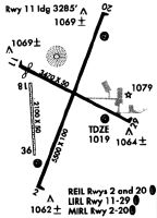
Runways
Runway Summary
| Runways: | 02/20 12/30 18/36 |
| Longest Runway: | 02/20 is 5500 ft (1676 m) long |
| Runways with an Instrument Approach: | 02 |
ISW Airport Runway Details
| Runway 02/20 | 5500 ft x 100 ft (1676 m x 30 m) | |
| Runway Length Source: | 3RD PARTY SURVEY as of 10/08/2009 | |
| Surface: | Asphalt - Excellent condition - No special surface treatment | |
| Runway Edge Lights: | Medium Intensity | |
Runway Weight Bearing Capacity (in thousands of pounds) |
||
| Single Wheel Landing Gear: | 40.0 | |
| Dual Wheel Landing Gear: | 60.0 | |
Runway 02 |
Runway 20 |
|
Elevation: |
1010.8 | 1021.0 |
Latitude: |
44-21-12.0703N | 44-22-03.1678N |
Longitude: |
089-50-30.6346W | 089-50-05.0118W |
|
Runway True Alignment: |
020 | 200 |
ILS Type: |
SDF | |
Glide Path Angle: |
3.0 degrees | 3.5 degrees |
Traffic Pattern: |
Left | Left |
Runway Markings Type: |
Nonprecision Instrument | Nonprecision Instrument |
Runway Markings Condition: |
Good | Good |
Object at End: |
TREES | TREE |
Object Height: |
15 | 68 |
Distance from End: |
250 | 1560 |
Object Centerline Offset: |
215 ft. right of centerline | 330 ft. left of centerline |
Visual Glide Slope Indicators: |
4-Light PAPI On Left Side Of Runway | 4-Light PAPI On Left Side Of Runway |
REIL: |
Yes | Yes |
Touchdown Lights: |
No | No |
Centerline Lights: |
No | No |
Threshold Crossing Height: |
35 | 42 |
| Runway 12/30 | 3470 ft x 60 ft (1058 m x 18 m) | |
| Runway Length Source: | STATE as of 03/11/2019 | |
| Surface: | Asphalt - Excellent condition - No special surface treatment | |
| Runway Edge Lights: | Medium Intensity | |
Runway Weight Bearing Capacity (in thousands of pounds) |
||
| Single Wheel Landing Gear: | 12.0 | |
| Dual Wheel Landing Gear: | 20.0 | |
Runway 12 |
Runway 30 |
|
Elevation: |
1020.0 | 1011.6 |
Latitude: |
44-21-47.2454N | 44-21-32.2700N |
Longitude: |
089-50-39.0620W | 089-49-56.1100W |
|
Runway True Alignment: |
116 | 296 |
Glide Path Angle: |
0.0 degrees | 4.0 degrees |
Traffic Pattern: |
Left | Left |
Runway Markings Type: |
Nonprecision Instrument | Nonprecision Instrument |
Runway Markings Condition: |
Good | Good |
Object at End: |
TREES | |
Object Height: |
93 | |
Distance from End: |
1880 | |
Object Centerline Offset: |
215 ft. right of centerline | 330 ft. left of centerline |
Visual Glide Slope Indicators: |
4-Light PAPI On Left Side Of Runway | |
REIL: |
No | No |
Touchdown Lights: |
No | No |
Centerline Lights: |
No | No |
Threshold Crossing Height: |
51 |
| Runway 18/36 | 2072 ft x 50 ft (632 m x 15 m) | |
| Runway Length Source: | ADO as of 03/11/2019 | |
| Surface: | Asphalt - Excellent condition - No special surface treatment | |
Runway 18 |
Runway 36 |
|
Elevation: |
1016.0 | 1014.9 |
Latitude: |
44-21-42.4200N | 44-21-22.0200N |
Longitude: |
089-50-33.8200W | 089-50-31.5900W |
|
Runway True Alignment: |
176 | 356 |
Glide Path Angle: |
0.0 degrees | 0.0 degrees |
Traffic Pattern: |
Left | |
Object Centerline Offset: |
215 ft. right of centerline | 330 ft. left of centerline |
Services
Airframe Repair: |
Major |
Powerplant Repair: |
Major |
Bottled Oxygen: |
None |
Bulk Oxygen: |
None |
Fuel Available: |
100LL, Jet A |
Landing Fees: |
No |
Parking: |
Hangars and tiedowns available |
Maps & Diagrams
ISW Sectional
Flight Planning
at skyvector.com
at skyvector.com