Location
Latitude: |
35-01-18.8750N (35.02191) |
Longitude: |
110-43-21.0568W (-110.722516) |
Elevation: |
4941.1 feet MSL (1506 m MSL) |
Magnetic Variation: |
9.6 E (as of April 2024 from WMM2020 model) |
Time Zone: |
UTC -7.0 (Standard Time) UTC -7.0 (Daylight Savings Time) |
From City: |
01 N.M. W of Winslow, Arizona |
Found On: |
Phoenix Chart |
FAA Region: |
AWP |
Contacts
Manager: |
Publicly owned: |
| JOHN C. BARKLEY 21 WILLIAMSON AVE WINSLOW, AZ 86047 (928) 289-2422 |
CITY OF WINSLOW 21 WILLIAMSON AVE WINSLOW, AZ 86047 928-289-2422 |
Operations
Airport Status: |
Operational |
Facility Use: |
Public |
Type: |
Airport |
Activation Date: |
04/1940 |
Control tower: |
No |
Attendance (Months/Days/Hours): |
Months/Days/Hours ALL/MON-FRI/0700-1800 |
Boundary ARTCC: |
ZAB (Albuquerque) |
Responsible ARTCC: |
ZAB (Albuquerque) |
Lighting Schedule: |
SEE RMK |
Segmented Circle Indicator: |
Yes |
Traffic Pattern Altitude (MSL): |
5941 feet (1811 m) |
NOTAMs Facility: |
INW |
NOTAM-D Service: |
Yes |
International Airport of Entry: |
No |
Customs Landing Rights: |
No |
Military Landing Rights: |
Yes |
Civil/Military Joint Use: |
No |
Based Aircraft
| Single Engine: | 5 |
| Multi Engine: | 1 |
| Jet Engine: | 1 |
Annual Operations (as of 12/31/2020)
| Total Operations: | 24210 | |
| GA Local: | 4250 | 17.6% |
| GA Itinerant: | 19390 | 80.1% |
| Military Aircraft: | 570 | 2.4% |
Communications
| CTAF: | 122.800 |
| Unicom: | 122.800 |
| ASOS: | 118.875 (928-289-0134) |
- APCH/DEP SVC PRVDD BY ALBUQUERQUE ARTCC (ZAB) ON FREQ 127.675/306.2 (WINSLOW RCAG).
Fixed Based Operators (FBOs) & Fuel
(Click on a business for detail)
Please help us keep this information up to date. This is a FREE SERVICE just like everything else on Airport Guide! If you see that a business needs to be added, modified, or deleted please fill out our Update Form.
To add, modify, or delete a business click here.
Please help us keep this information up to date. This is a FREE SERVICE just like everything else on Airport Guide! If you see that a business needs to be added, modified, or deleted please fill out our Update Form.
Area Code: 520 |
| Business Name | Frequency | Phone | Fuel Grade |
|---|---|---|---|
| City of Winslow
Update FBO info |
Unicom 122.8 | 289-2429 | 100LL, Jet A |
| Windwalker Aviation
Update FBO info |
Unicom 122.8 | 289-5917, 800-308-0383 |
Flight Service Stations
| Primary | Alternate | |
| FSS on Field: | N | |
| FSS Name (ID): | Prescott(PRC) | |
| Frequency: | ||
| Toll Free Phone: | 1-800-WX-BRIEF |
Instrument Procedures / Charts
FAA Terminal Procedures valid from 0901Z 03/21/24 to 0901Z 04/18/24.
There are various types of charts available for an airport. They are listed in the Page Type column. Here is a legend for those types:
APD - Airport Diagram
DP - Departure Procedure Charts
HOT - Hot Spots
IAP - Instrument Approach Procedure Charts
MIN - Minimums
STAR - Standard Terminal Arrival Charts
| Page Type | Page Name | Volume | Action Since Last Cycle |
|---|---|---|---|
| IAP | VOR OR GPS RWY 11 | SW-4 | |
| MIN | ALTERNATE MINIMUMS | SW-4 | |
| MIN | TAKEOFF MINIMUMS | SW-4 |
Terminal Procedures are only available for airports in several countries with more being added all the time. If you are looking for a specific country's charts, please send an email to support(at)airportguide.com stating the country name. This will be used to prioritize the implementation.
Navigation Aids (Navaids) near INW
| Dist (NM) | ID | Morse Code | Name | Type | Freq | True Hdg | Mag Hdg |
|---|---|---|---|---|---|---|---|
| 4.3 | INW | . . _ . . _ _ | Winslow | VORTAC | 112.60 | 303 | 293 |
| 47.3 | FLG | . . _ . . _ . . _ _ . | Flagstaff | VOR-DME | 113.85 | 279 | 269 |
| 55.1 | PAN | . _ _ . . _ _ . | Payson | DME | 116.35 | 213 | 203 |
| 57.4 | SOW | . . . _ _ _ . _ _ | Show Low | NDB | 206 | 141 | 132 |
| 71.2 | TBC | _ _ . . . _ . _ . | Tuba City | VORTAC | 113.50 | 338 | 328 |
| 77.1 | ZUN | _ _ . . . . _ _ . | Zuni | VORTAC | 113.40 | 92 | 83 |
| 85.7 | SJN | . . . . _ _ _ _ . | St Johns | VORTAC | 112.30 | 114 | 105 |
| 86.6 | PRC | . _ _ . . _ . _ . _ . | Prescott | VOT | 110.00 | 255 | 245 |
| 88.6 | DRK | _ . . . _ . _ . _ | Drake | VORTAC | 114.10 | 258 | 248 |
| 89.5 | GCN | _ _ . _ . _ . _ . | Grand Canyon | VOR-DME | 111.65 | 309 | 299 |
| 89.7 | AWR | . _ . _ _ . _ . | Window Rock | NDB | 254 | 64 | 55 |
| 94.6 | GUP | _ _ . . . _ . _ _ . | Gallup | VORTAC | 115.10 | 72 | 63 |
Nearby Airports with Fuel
| Dist (NM) | Name (Airport IDs) | True Hdg | Mag Hdg | Fuel Grade |
|---|---|---|---|---|
| 29.1 | Holbrook Municipal Airport (P14) |
99 | 90 | 100LL |
| 45.4 | Taylor Airport (TYZ KTYL TYL) |
138 | 129 | 100LL |
| 47.0 | Flagstaff Pulliam Airport (FLG KFLG FLG) |
278 | 268 | 100LL, Jet A |
| 53.5 | Sedona Airport (SDX KSEZ SEZ) |
259 | 249 | 100LL, Jet A |
| 55.1 | Payson Airport (PJB KPAN PAN) |
213 | 203 | 100LL, Jet A+ |
| 57.5 | Show Low Regional Airport (SOW KSOW SOW) |
141 | 132 | 100LL, Jet A |
| 72.8 | St Johns Industrial Air Park Airport (SJN KSJN SJN) |
114 | 105 | 100LL, Jet A+ |
| 74.2 | H A Clark Meml Field Airport (KCMR CMR) |
283 | 273 | 100LL, Jet A-1+ |
| 79.3 | Valle Airport (VLE 40G) |
298 | 288 | 100LL, Jet A |
| 86.4 | Prescott Regional - Ernest A Love Field Airport (PRC KPRC PRC) |
255 | 245 | 100LL, Jet A |
| 89.2 | Grand Canyon Ntl Park Airport (GCN KGCN GCN) |
309 | 299 | 100LL, Jet A |
| 89.4 | Window Rock Airport (KRQE RQE) |
64 | 55 | 100LL |
| 99.1 | Gallup Municipal Airport (GUP KGUP GUP) |
72 | 63 | 100LL, Jet A-1+ |
Notices to Airmen (NOTAMS)
Remarks
| A110-2 | SW CORNER OF FOREST SERVICE RAMP CLSD. |
| A110-3 | FOR CD IF UNA TO CTC ON FSS FREQ, CTC ALBUQUERQUE ARTCC AT 505-856-4561. |
| A14 | ALTERNATE CONTACT: ORVILLE WISEMAN, FBO, 928-607-9933 OR 928-289-0100. |
| A17 | AFTER HRS SERVICE CALL 928-587-2630. |
| A24 | LANDING FEE FOR COMMERICAL ACFT. OVERNIGHT TIEDOWN FEE. |
| A33-11/29 | OUTER 35 FT ON EACH SIDE EXTREMELY ROUGH DUE TO VEGETATION GROWING IN NUMEROUS CRACKS. |
| A57-11 | CLEARANCE SLOPE TO DISPLACED THRESHOLD IS 50:1 |
| A57-22 | APCH RATIO, 50:1 TO DTHR. |
| A58-22 | 15 FT DITCH, 15 FT FROM THLD, ACROSS THE APPROACH. |
| A58-29 | APPX 8 FT FENCE 200 FT FROM RWY END; ACROSS RWY END. APPX 2-TO-3 FT BRUSH, 0-TO-200 FT FROM THLD ACROSS RWY END. |
| A81-APT | ACTVT REIL RWY 11 & 22; MIRL RWY 04/22 & 11/29 - CTAF. VASI RWY 11 & 29 OPER CONT. |
| A84 | SEGMETED CIRCLE MISSING RIGHT TRAFFIC ARMS FOR RY 11. |
| E111 | ESTABD PRIOR TO 1959. |
Runways
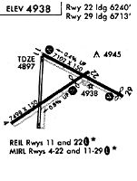
Runway Summary
| Runways: | 04/22 11/29 |
| Longest Runway: | 04/22 is 7499 ft (2286 m) long |
| Runways with an Instrument Approach: |
INW Airport Runway Details
| Runway 04/22 | 7499 ft x 150 ft (2286 m x 46 m) | |
| Runway Length Source: | 3RD PARTY SURVEY as of 01/23/2015 | |
| Surface: | Asphalt - Good condition - No special surface treatment | |
| Runway Edge Lights: | Medium Intensity | |
Runway Weight Bearing Capacity (in thousands of pounds) |
||
| Single Wheel Landing Gear: | 50.0 | |
| Dual Wheel Landing Gear: | 80.0 | |
| Dual Tandem Wheel Landing Gear: | 125.0 | |
Runway 04 |
Runway 22 |
|
Elevation: |
4941.1 | 4881.1 |
Latitude: |
35-00-51.3600N | 35-01-29.9920N |
Longitude: |
110-44-16.3600W | 110-42-59.4220W |
|
Runway True Alignment: |
059 | 239 |
Glide Path Angle: |
0.0 degrees | 3.0 degrees |
Traffic Pattern: |
Left | Left |
Runway Markings Type: |
Nonprecision Instrument | Nonprecision Instrument |
Runway Markings Condition: |
Fair | Fair |
Object at End: |
TREE | |
Object Height: |
18 | |
Distance from End: |
219 | |
Object Centerline Offset: |
0 ft. left and right of centerline | |
Visual Glide Slope Indicators: |
4-Box VASI On Left Side Of Runway | |
REIL: |
No | Yes |
Touchdown Lights: |
No | No |
Centerline Lights: |
No | No |
Threshold Crossing Height: |
40 | |
Threshold Elevation: |
4881.1 | |
Displaced Threshold: |
1262 | |
Threshold Latitude: |
35-01-23.4900N | |
Threshold Longitude: |
110-43-12.3700W | |
Declared Distances |
||
Landing Dist. Avbl. (LDA): |
7499 | 6236 |
| Runway 11/29 | 7100 ft x 150 ft (2164 m x 46 m) | |
| Runway Length Source: | 3RD PARTY SURVEY as of 04/19/2010 | |
| Surface: | Asphalt - Good condition - No special surface treatment | |
| Runway Edge Lights: | Medium Intensity | |
Runway Weight Bearing Capacity (in thousands of pounds) |
||
| Single Wheel Landing Gear: | 60.0 | |
| Dual Wheel Landing Gear: | 70.0 | |
| Dual Tandem Wheel Landing Gear: | 110.0 | |
Runway 11 |
Runway 29 |
|
Elevation: |
4899.3 | 4870.0 |
Latitude: |
35-01-44.9039N | 35-01-10.1599N |
Longitude: |
110-43-40.3589W | 110-42-26.2025W |
|
Runway True Alignment: |
120 | 300 |
Glide Path Angle: |
3.0 degrees | 3.0 degrees |
Traffic Pattern: |
Right | Left |
Runway Markings Type: |
Nonprecision Instrument | Nonprecision Instrument |
Runway Markings Condition: |
Fair | Fair |
Object at End: |
TREE | FENCE |
Object Height: |
17 | 8 |
Distance from End: |
618 | 201 |
Object Centerline Offset: |
0 ft. left and right of centerline | |
Visual Glide Slope Indicators: |
4-Box VASI On Left Side Of Runway | 4-Box VASI On Left Side Of Runway |
REIL: |
Yes | No |
Touchdown Lights: |
No | No |
Centerline Lights: |
No | No |
Threshold Crossing Height: |
36 | 28 |
Threshold Elevation: |
4870.4 | |
Displaced Threshold: |
344 | |
Threshold Latitude: |
35-01-11.8425N | |
Threshold Longitude: |
110-42-29.7947W | |
Declared Distances |
||
Landing Dist. Avbl. (LDA): |
7100 | 6756 |
Services
Airframe Repair: |
None |
Powerplant Repair: |
None |
Bottled Oxygen: |
None |
Fuel Available: |
100LL, Jet A-1+ |
Landing Fees: |
No |
Parking: |
Hangars and tiedowns available |
Maps & Diagrams
INW Sectional
Flight Planning
at skyvector.com
at skyvector.com