
Location
Latitude: |
46-14-17.1533N (46.238098) |
Longitude: |
006-06-32.2205E (6.10895) |
Elevation: |
1411 feet MSL (430 m MSL) |
Magnetic Variation: |
2.8 E (as of April 2024 from WMM2020 model) |
Time Zone: |
UTC +1.0 (Standard Time) UTC +2.0 (Daylight Savings Time) |
Contacts
Manager: |
: |
Operations
Airport Status: |
Operational |
Facility Use: |
Public |
Type: |
Airport |
Traffic Pattern Altitude (MSL): |
2411 feet (735 m) |
Based Aircraft
Annual Operations (as of )
Communications
| TWR: | 118.7 |
| Nadirgul ground: | 123.25 |
| GND: | 121.675 |
| APP: | 120.3 |
| DEP: | 119.525 |
| ATIS: | 135.575 |
| APN: | 121.75 |
| AFIS: | 123.5 |
| MIHALOVEC: | 123.5 |
| Vzletišče Mostje: | 123.5 |
| ARR: | 136.25 |
| Vzletišče Veržej: | 123.5 |
Fixed Based Operators (FBOs) & Fuel
(Click on a business for detail)
Please help us keep this information up to date. This is a FREE SERVICE just like everything else on Airport Guide! If you see that a business needs to be added, modified, or deleted please fill out our Update Form.
To add, modify, or delete a business click here.
Please help us keep this information up to date. This is a FREE SERVICE just like everything else on Airport Guide! If you see that a business needs to be added, modified, or deleted please fill out our Update Form.
| Business Name | Frequency | Phone | Fuel Grade |
|---|
Flight Service Stations
| Primary | Alternate | |
| FSS on Field: | ||
| FSS Name (ID): | ||
| Frequency: | ||
| Toll Free Phone: |
Instrument Procedures / Charts
Terminal Procedures are only available for airports in several countries with more being added all the time. If you are looking for a specific country's charts, please send an email to support(at)airportguide.com stating the country name. This will be used to prioritize the implementation.
Navigation Aids (Navaids) near GVA
| Dist (NM) | ID | Morse Code | Name | Type | Freq | True Hdg | Mag Hdg |
|---|---|---|---|---|---|---|---|
| 1.4 | GVA | Geneva Cointrin | VOR-DME | 115.75 | 45 | 42 | |
| 6.4 | PAS | Passeiry | VOR-DME | 116.60 | 225 | 222 | |
| 11.7 | GLA | Gland | NDB | 375 | 28 | 25 | |
| 19.7 | SPR | St-Prex | VOR-DME | 113.90 | 45 | 42 | |
| 25.9 | CBY | Chambery | VOR-DME | 115.40 | 214 | 211 | |
| 29.1 | LAP | La Praz | DME | 110.65 | 25 | 22 | |
| 35.6 | AMU | Amberieu | TACAN | 116.30 | 245 | 242 | |
| 49.0 | SIO | Sion | VOR-DME | 112.15 | 91 | 88 | |
| 51.7 | LSE | Lyon/Saint Exupery | VOR-DME | 114.75 | 235 | 232 | |
| 52.9 | LNP | Tour Du Pin | VOR | 113.45 | 212 | 209 | |
| 52.9 | LTP | La Tour Du Pin | VOR-DME | 115.55 | 212 | 209 | |
| 56.3 | FRI | Fribourg | VOR-DME | 110.85 | 54 | 51 | |
| 58.0 | MOT | Montana | VOR-DME | 115.85 | 85 | 82 | |
| 58.0 | LPS | Les Eplatures | NDB | 403 | 28 | 25 | |
| 65.5 | VNE | Vienne | VOR | 108.20 | 231 | 228 | |
| 70.1 | BER | Bern | NDB | 335 | 55 | 52 | |
| 70.3 | MUR | Muri | NDB | 312 | 52 | 49 | |
| 70.7 | SHU | Schupberg | NDB | 357 | 47 | 44 | |
| 74.6 | DJL | Dijon | VOR-DME | 111.45 | 326 | 323 | |
| 74.8 | DIJ | Dijon | TACAN | 113.50 | 326 | 323 |
Nearby Airports with Fuel
| Dist (NM) | Name (Airport IDs) | True Hdg | Mag Hdg | Fuel Grade |
|---|---|---|---|---|
| 52.4 | Lyon Saint-Exupéry Airport (LYS LFLL) |
234 | 231 | Jet A-1 |
Notices to Airmen (NOTAMS)
Remarks
No remarks for this landing facility
Runways
Runway Summary
| Runways: | 04/22 [X] 04L/22R |
| Longest Runway: | 04/22 is 12795 ft (3900 m) long |
| Runways with an Instrument Approach: |
GVA Airport Runway Details
| Runway 04/22 | 12795 ft x 164 ft (3900 m x 50 m) | |
| Runway Edge Lights: | Yes Intensity | |
Runway 04 |
Runway 22 |
|
Elevation: |
1411 | 1365 |
Latitude: |
46.22579956054 | 46.25040054321 |
Longitude: |
6.0909199714660 | 6.1269898414611 |
|
Runway True Alignment: |
45.5 | 225.5 |
Glide Path Angle: |
0.0 degrees | 0.0 degrees |
REIL: |
Yes | Yes |
Threshold Elevation: |
1411 | 1365 |
Displaced Threshold: |
1082 |
| Runway [X] 04L/22R | 2700 ft x 98 ft (823 m x 30 m) | |
Runway [X] 04L |
Runway [X] 22R |
|
Elevation: |
1378 | 1393 |
Latitude: |
46.234798 | 46.239899 |
Longitude: |
6.0995 | 6.10722 |
|
Runway True Alignment: |
46 | 226 |
Glide Path Angle: |
0.0 degrees | 0.0 degrees |
Threshold Elevation: |
1378 | 1393 |
Displaced Threshold: |
613 | 994 |
Services
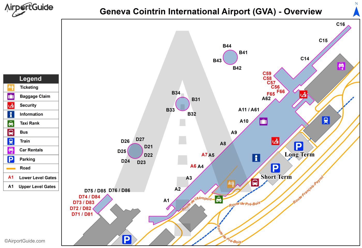
Maps & Diagrams
GVA Sectional
Flight Planning
at skyvector.com
at skyvector.com
