Location
Latitude: |
30-24-26.1690N (30.407269) |
Longitude: |
089-04-12.3450W (-89.070096) |
Elevation: |
28.0 feet MSL (9 m MSL) |
Magnetic Variation: |
2.1 W (as of April 2024 from WMM2020 model) |
Time Zone: |
UTC -6.0 (Standard Time) UTC -5.0 (Daylight Savings Time) |
From City: |
03 N.M. NE of Gulfport, Mississippi |
Found On: |
New Orleans Chart |
FAA Region: |
ASO |
Contacts
Manager: |
Publicly owned: |
| CLAY WILLIAMS 14035-L AIRPORT RD GULFPORT, MS 39503 228-863-5951 |
GULFPORT-BILOXI RGNL APT AUTH 14035-L AIRPORT RD GULFPORT, MS 39503 228-863-5951 |
Operations
Airport Status: |
Operational |
Facility Use: |
Public |
Type: |
Airport |
Control tower: |
Yes |
Attendance (Months/Days/Hours): |
Months/Days/Hours ALL/ALL/ALL |
Boundary ARTCC: |
ZHU (Houston) |
Responsible ARTCC: |
ZHU (Houston) |
Lighting Schedule: |
SEE RMK |
Segmented Circle Indicator: |
Yes |
Traffic Pattern Altitude (MSL): |
1028 feet (313 m) |
NOTAMs Facility: |
GPT |
NOTAM-D Service: |
Yes |
International Airport of Entry: |
No |
Customs Landing Rights: |
Yes |
Military Landing Rights: |
Yes |
Civil/Military Joint Use: |
No |
Aircraft Rescue and Firefighting: |
Class I ARFF Index: B Air Carrier Service: Scheduled Certification Date: 05/1973 |
Based Aircraft
| Single Engine: | 31 |
| Multi Engine: | 2 |
| Jet Engine: | 5 |
| GA Helicopters: | 3 |
Annual Operations (as of 04/30/2023)
| Total Operations: | 56987 | |
| Commercial: | 6966 | 12.2% |
| Air Taxi: | 3548 | 6.2% |
| GA Local: | 9396 | 16.5% |
| GA Itinerant: | 12125 | 21.3% |
| Military Aircraft: | 24952 | 43.8% |
Communications
| CTAF: | 123.700 |
| Unicom: | 122.950 |
| Tower: | GULFPORT 123.7 339.8 Hrs: 0600-2300 |
| Ground: | 120.4 348.6 |
| Approach: | GULFPORT 124.6 ;130-309 127.5 ;310-129 254.25 ;310-129 354.1 ;130-309 Hrs: 0600-2300 HOUSTON ARTCC Hrs: 2300-0600 |
| Departure: | GULFPORT 124.6 ;130-309 127.5 ;310-129 254.25 ;310-129 354.1 ;130-309 Hrs: 0600-2300 HOUSTON ARTCC Hrs: 2300-0600 |
| ATIS: | 119.45 Hrs: 24 |
| ASOS: | 119.45 (228-867-9937) |
| EMERG: | 243.0 |
| EMERG: | 121.5 |
| TRSA: | 254.25 ;310-129 |
| TRSA: | 124.6 ;130-309 |
| FINAL CTL: | 126.75 |
| TRSA: | 354.1 ;130-309 |
| FINAL CTL: | 397.95 |
| TRSA: | 127.5 ;310-129 |
- APCH/DEP SVC PRVDD BY HOUSTON ARTCC (ZHU) ON FREQS 127.65/285.475 (MOBILE RCAG) WHEN GULFPORT APCH CTL (GPT) CLSD.
Fixed Based Operators (FBOs) & Fuel
(Click on a business for detail)
Please help us keep this information up to date. This is a FREE SERVICE just like everything else on Airport Guide! If you see that a business needs to be added, modified, or deleted please fill out our Update Form.
To add, modify, or delete a business click here.
Please help us keep this information up to date. This is a FREE SERVICE just like everything else on Airport Guide! If you see that a business needs to be added, modified, or deleted please fill out our Update Form.
Area Code: 228 |
| Business Name | Frequency | Phone | Fuel Grade |
|---|---|---|---|
| FBO AVCENTER
Update FBO info |
Unicom 122.95 | 863-2570 | 100LL, Jet A |
Flight Service Stations
| Primary | Alternate | |
| FSS on Field: | N | |
| FSS Name (ID): | Greenwood(GWO) | |
| Frequency: | ||
| Toll Free Phone: | 1-800-WX-BRIEF |
Instrument Procedures / Charts
FAA Terminal Procedures valid from 0901Z 03/21/24 to 0901Z 04/18/24.
There are various types of charts available for an airport. They are listed in the Page Type column. Here is a legend for those types:
APD - Airport Diagram
DP - Departure Procedure Charts
HOT - Hot Spots
IAP - Instrument Approach Procedure Charts
MIN - Minimums
STAR - Standard Terminal Arrival Charts
| Page Type | Page Name | Volume | Action Since Last Cycle |
|---|---|---|---|
| APD | AIRPORT DIAGRAM | SC-4 | |
| IAP | HI-ILS Y OR LOC Y RWY 14 | SC-4 | |
| IAP | HI-ILS Y OR LOC Y RWY 32 | SC-4 | |
| IAP | HI-TACAN Y RWY 14 | SC-4 | |
| IAP | ILS Z OR LOC Z RWY 14 | SC-4 | |
| IAP | ILS Z OR LOC Z RWY 32 | SC-4 | |
| IAP | ILS Z RWY 14 (SA CAT II) | SC-4 | |
| IAP | RNAV (GPS) RWY 14 | SC-4 | |
| IAP | RNAV (GPS) RWY 18 | SC-4 | |
| IAP | RNAV (GPS) RWY 32 | SC-4 | |
| IAP | RNAV (GPS) RWY 36 | SC-4 | |
| IAP | VOR Y RWY 14 | SC-4 | |
| IAP | VOR Y RWY 32 | SC-4 | |
| IAP | VOR Z OR TACAN Z RWY 14 | SC-4 | |
| IAP | VOR Z RWY 32 | SC-4 | |
| MIN | ALTERNATE MINIMUMS | SC-4 | |
| MIN | RADAR MINIMUMS | SC-4 | Changed |
| MIN | TAKEOFF MINIMUMS | SC-4 |
Terminal Procedures are only available for airports in several countries with more being added all the time. If you are looking for a specific country's charts, please send an email to support(at)airportguide.com stating the country name. This will be used to prioritize the implementation.
Navigation Aids (Navaids) near GPT
| Dist (NM) | ID | Morse Code | Name | Type | Freq | True Hdg | Mag Hdg |
|---|---|---|---|---|---|---|---|
| 0.3 | GPT | _ _ . . _ _ . _ | Gulfport | VORTAC | 109.00 | 265 | 267 |
| 6.7 | GP | _ _ . . _ _ . | Bayou | NDB | 360 | 314 | 316 |
| 7.3 | BIX | _ . . . . . _ . . _ | Keesler | TACAN | 111.80 | 90 | 92 |
| 20.1 | HS | . . . . . . . | Hanco | NDB | 221 | 277 | 279 |
| 35.4 | PCU | . _ _ . _ . _ . . . _ | Picayune | VOR-DME | 113.95 | 285 | 287 |
| 41.4 | SJI | . . . . _ _ _ . . | Semmes | VORTAC | 115.30 | 62 | 64 |
| 44.9 | MOB | _ _ _ _ _ _ . . . | Wisle | NDB | 248 | 61 | 63 |
| 49.8 | GVB | _ _ . . . . _ _ . . . | Bogalusa | NDB | 353 | 305 | 307 |
| 51.2 | GCV | _ _ . _ . _ . . . . _ | Greene County | VORTAC | 115.70 | 35 | 37 |
| 53.9 | BFM | _ . . . . . _ . _ _ | Brookley | VORTAC | 116.35 | 76 | 78 |
| 58.8 | HRV | . . . . . _ . . . . _ | Harvey | VORTAC | 114.10 | 235 | 237 |
| 62.2 | LBY | . _ . . _ . . . _ . _ _ | Eaton | VORTAC | 110.60 | 347 | 349 |
| 69.8 | ESU | . . . . . . _ | Summerdale | NDB | 204 | 85 | 88 |
| 70.0 | HMU | . . . . _ _ . . _ | Hammond | VOR | 109.60 | 275 | 277 |
| 70.9 | HP | . . . . . _ _ . | Anger | NDB | 212 | 280 | 282 |
| 72.7 | MS | _ _ . . . | Kinte | NDB | 338 | 251 | 253 |
| 77.1 | THJ | _ . . . . . _ _ _ | Tallahala | NDB | 346 | 355 | 357 |
| 81.0 | RQR | . _ . _ _ . _ . _ . | Reserve | VOR-DME | 110.80 | 256 | 258 |
| 81.5 | MCB | _ _ _ . _ . _ . . . | Mc Comb | VORTAC | 116.70 | 311 | 313 |
| 89.8 | NUN | _ . . . _ _ . | Saufley | VOR | 112.25 | 87 | 90 |
Nearby Airports with Fuel
Notices to Airmen (NOTAMS)
Remarks
| A110-1 | NMRS LOW FLYING FISH SPOTTER ACFT OPERG THE SHORELINE BTN PASCAGOULA & GULFPORT SR-SS. |
| A110-10 | ACFT OPERG AS SKED OR CHARTER PSGR SVC SHALL NOT TAXI ON TWY 'A' NORTH OF TWY 'B' INTXN WO ESCORT FROM GND HANDLING AGENT OR ARPT AUTH. |
| A110-11 | CIVIL ACFT WITH WING SPAN OF 132 FT OR GREATER AND ALL ACR ACFT MUST BE ESCORTED ALONG TWY 'A' NORTH OF TWY 'C' BY GND HANDLING AGENT. |
| A110-12 | MILITARY ACFT OR ACFT SUPPORTING A MIL MISSION WITH WING SPAN OF 132 FT OR GREATER MUST HAVE ESCORT OR COORD TAXI PROCS WITH GND HANDLING AGENT PRIOR TO TXG ON TWY 'A'. |
| A110-13 | MAVERICK PAD APRON AREA ON N END OF TWY C RSTRD TO MIL ARCFT USE ONLY. |
| A110-14 | ARRESTING GEAR AVBL DURING ANG OPNS WITH 30 MIN PRIOR NOTICE. |
| A110-15 | CSTMS/AG/IMG: REQR OF PPR RESPONSIBLE FOR NTFYG CSTMS 48 HRS PRIOR NOTICE. |
| A110-16 | RSTD: C-5 ACFT PRK RSTD TO 1 ACFT AT A TIME DUE TO TXY WIDTH UNLESS COORD. |
| A110-17 | MILITARY: ANG: NO COMSEC STOR. CRTC AFLD MGMT OPS OPR 1300-2130Z++ MON; 1300-2230Z++ TUES-FRI & UNIT TRNG ASSEMBLY (UTA) WKNDS, NORMALLY FIRST WKND OF MONTH; CLSD HOL. 48 HR PN PPR RQR CTC CRTC AM OPS. CTC GUARD OPS 15 MIN PRIOR TO ARR 377.800. DSN 363-6027; C228-214-6027; FAX DSN 363-6031; C228-214-6031. |
| A110-18 | MILITARY: CAUTION: BASH PHASE II IN EFCT APR-MAY AND AUG-OCT. CTC AFLD MGMT FOR CURRENT BIRD WATCH COND. |
| A110-21 | PWR CHK PAD BTN RWY 18/36 AND TWY A RSTD TO MIL ACFT ONLY. |
| A110-22 | TAXILANE F20 BTN FBO AND TAXILANE G CLSD TO ACFT WITH WINGSPAN GREATER THAN 49 FT. POLE ADJ TAXILANE F20 NOT LGTD. |
| A110-23 | FUEL A+ (MIL) A (MILLION AIR GULFPORT, (C228-701-0400). |
| A110-24 | MILITARY: RSTD: PRK RSTD WI 100 FT LOX FAC LCTD NE CORNER APRON 1. |
| A110-25 | MILITARY: ANG: LTD SVC AVBL SPACE A PERS, NO PAX TERMINAL. |
| A110-26 | MILITARY: ARNG: MSAVCRAD OPS OPR 1300-2130Z++ MON; 1300-2230Z++ TUE-FRI & UNIT TRNG ASSEMBLY (UTA) WKND. PPR RQR CTC ARNG OPS, DSN 293-1378/1312, C228-214-1378/1312. ACFT INBD TO ARNG RAMP CTC BLACKJACK OPS (241.0/41.6) 10 MIN PRIOR TO LDG FOR PRK INSTR. |
| A110-27 | RWY 18/36 NOT AVBL FOR SKEDD ACR OPS WITH MORE THAN 9 PAX SEATS OR UNSKED ACR OPS AT LEAST 31 PAX SEATS. |
| A110-3 | ACFT OVER 115,000 LBS ARE RSTRD FROM 180 DEG TURNS ON RWY 18/36. ACFT WITH WINGSPAN GREATER THAN 223 FT ARE RSTRD FM OPRG ON TWY 'C' BTN TWY 'A' AND AER 32. |
| A110-4 | ACFT OVER 155000 LBS ARE RSTRD FM USING THE N PART OF TWY 'A' AT RY 18/36. ACFT OVER 316000 LBS ARE RSTRD FM USING THE S PART OF TWY 'A' BTN TWY 'C' & RY 14/32. |
| A110-5 | DUE TO APRON ACTVTY ACFT WITH WINGSPAN GREATER THAN 170 FT SHOULD BE ALERT ON TWY 'A' BTN TWY 'C' & TWY 'B'. |
| A110-9 | 150 FT AGL CRANE 4600 FT N OF RWY 18 THLD. |
| A35-14/32 | 2S-175. |
| A39-14/32 | PCR VALUE: 960/F/B/X/T |
| A81-APT | WHEN ATCT CLSD ACTVT MALSR RWY 14 & 32; HIRL RWY 14/32; MIRL RWY 18/36 - CTAF. MIRL RWY 18/36 NOT AVBL WHEN ATCT CLSD & RWY 14/32 ACTV. |
| E111 | EXISTED PRIOR TO 1959. |
| E147 | TPA: 800 FT AGL LGT SNGL-ENG, 1200 FT AGL CONVENTIONAL, 1500 FT AGL JETS. |
| E60-14 | BAK-14 BAK-12B(B) (1800 FT). |
| E60-32 | BAK-14 BAK-12B(B) (1300 FT). |
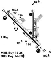
Runways
Runway Summary
| Runways: | 14/32 18/36 |
| Longest Runway: | 14/32 is 9002 ft (2744 m) long |
| Runways with an Instrument Approach: | 14, 32 |
GPT Airport Runway Details
| Runway 14/32 | 9002 ft x 150 ft (2744 m x 46 m) | |
| Runway Length Source: | 3RD PARTY SURVEY as of 06/06/2019 | |
| Surface: | Asphalt/Concrete - Good condition - Saw-cut or plastic grooved | |
| Runway Edge Lights: | High Intensity | |
Runway Weight Bearing Capacity (in thousands of pounds) |
||
| Single Wheel Landing Gear: | 81.0 | |
| Dual Wheel Landing Gear: | 300.0 | |
| Dual Tandem Wheel Landing Gear: | 555.0 | |
| Dual Dual Tandem Wheel Landing Gear: | 870.0 | |
Runway 14 |
Runway 32 |
|
Elevation: |
18.9 | 22.0 |
Latitude: |
30-24-53.8374N | 30-23-50.9235N |
Longitude: |
089-04-56.2959W | 089-03-43.5091W |
|
Runway True Alignment: |
135 | 315 |
ILS Type: |
ILS | ILS |
Glide Path Angle: |
3.0 degrees | 3.0 degrees |
Traffic Pattern: |
Left | Left |
Runway Markings Type: |
Precision Instrument | Precision Instrument |
Runway Markings Condition: |
Good | Good |
Arresting Device: |
BAK-14 | BAK-14 |
Object at End: |
TREES | TOWER |
Object Height: |
50 | 70 |
Object Marked/Lighted?: |
Lighted | |
Distance from End: |
1900 | 2100 |
Object Centerline Offset: |
300 ft. right of centerline | 0 ft. left and right of centerline |
Visual Glide Slope Indicators: |
4-Light PAPI On Right Side Of Runway | 4-Light PAPI On Left Side Of Runway |
Runway Visual Range (RVR): |
Touchdown | Touchdown |
Approach Light System: |
1,400 Foot Medium Intensity Approach Lighting System With Runway Alignment Indicator Lights | 1,400 Foot Medium Intensity Approach Lighting System With Runway Alignment Indicator Lights |
REIL: |
No | No |
Threshold Crossing Height: |
73 | 72 |
| Runway 18/36 | 4935 ft x 150 ft (1504 m x 46 m) | |
| Runway Length Source: | 3RD PARTY SURVEY as of 06/06/2019 | |
| Surface: | Asphalt/Concrete - Good condition - Saw-cut or plastic grooved | |
| Runway Pavement Class: | 147/F/B/W/T | |
| Runway Edge Lights: | Medium Intensity | |
Runway Weight Bearing Capacity (in thousands of pounds) |
||
| Single Wheel Landing Gear: | 20.0 | |
| Dual Tandem Wheel Landing Gear: | 115.0 | |
Runway 18 |
Runway 36 |
|
Elevation: |
23.5 | 25.5 |
Latitude: |
30-24-57.5006N | 30-24-08.6532N |
Longitude: |
089-03-58.6479W | 089-03-58.4857W |
|
Runway True Alignment: |
180 | 360 |
Glide Path Angle: |
3.0 degrees | 3.0 degrees |
Traffic Pattern: |
Left | Left |
Runway Markings Type: |
Nonprecision Instrument | Nonprecision Instrument |
Runway Markings Condition: |
Good | Good |
Object at End: |
TREE | TREES |
Object Height: |
42 | 40 |
Distance from End: |
1300 | 1800 |
Object Centerline Offset: |
300 ft. right of centerline | 0 ft. left and right of centerline |
Visual Glide Slope Indicators: |
4-Light PAPI On Right Side Of Runway | 4-Light PAPI On Left Side Of Runway |
REIL: |
No | No |
Threshold Crossing Height: |
50 | 50 |
Services
Airframe Repair: |
Minor |
Powerplant Repair: |
Minor |
Bottled Oxygen: |
None |
Bulk Oxygen: |
None |
Fuel Available: |
100LL, Jet A-1+ |
Landing Fees: |
No |
Parking: |
Hangars and tiedowns available |
Maps & Diagrams
GPT Sectional
Flight Planning
at skyvector.com
at skyvector.com